Salt (Sodium Chloride) and the Mar Menor, Spain EarthCache
Salt (Sodium Chloride) and the Mar Menor, Spain
-
Difficulty:
-

-
Terrain:
-
Size:  (not chosen)
Please note Use of geocaching.com services is subject to the terms and conditions
in our disclaimer.
The Mar Menor (which translates as little sea) is a salt water
lagoon in south-east Murcia, Spain. It is separated from the
Mediterranean sea by La Manga (which translates as The
Sleeve).
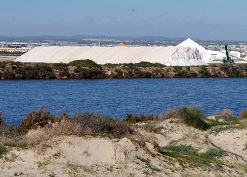
The Salt Evaporation Pond and the Harvested Salt
La Manga is a sandbar around 22km in length and with a variable
width from 100 to 1200m. The surface area of the Mar Menor is
around 170km² and the coastal length (all the way around the
outside of it) is around 73km. The water is warm and clear and does
not exceed 7m in depth. This makes the Mar Menor Europes greatest
salt water lake.
Because the Mar Menor has a high salinity (meaning it has a higher
concentration than normal of salt in sea water) it aids flotation.
If you floated in the sea you would notice that more of your body
would protude from the water than if you floated in fresh water for
example.
Another example that shows that the Mar Menor has such a high salt
content are the Salt Flats and the Salt Evaporation Ponds. Salt
Evaporation Ponds are shallow man-made ponds. They are designed to
produce salt from the sea water. The seawater is allowed to flow
into the large ponds. They are then blocked up and the seawater is
allowed to evaporate naturally. The salt can then be harvested. The
Salt Evaporation Ponds also provide a productive resting and
feeding ground for many species of waterbirds, including several
endangered species. Flamingoes are often seen here.
Other well known Salt Evaporation Ponds around the world
include:
the San Francisco Bay salt ponds in the United States
the Dead Sea salt ponds in Israel and Jordan
the Useless Loop and Onslow salt ponds in Western Australia
The mud from the Mar Menor is also well known for it's therapeutic
qualities. It has been analysed and contains a high percentage of
calcium, magnesium, potassium and flouride. It also has some
chlorine and sulphur. The quantities of these minerals is much
higher than is usually found in water with such a high level of
salinity. The PH value for the mud varies between PH 7.12 and PH
8.45.
The importance of Salt in the human diet cannot be over emphasised.
Sodium is one of the primary electrolytes in the body. Salt
contains many vital minerals needed for proper bodily function. Too
much or too little salt in the diet can lead to muscle cramps,
dizziness, or electrolyte disturbance, which can cause neurological
problems, or indeed be fatal. Drinking too much water and consuming
too little salt, puts a person at risk of water intoxication.
However salt is also dangerous if excessive salt is consumed in the
long term. It is associated with increased risk of stroke, heart
problems and cardiovascular disease.
To log the cache, Please answer the
following questions:
Questions, see the notice board at
the waypoint below (N 37° 49.276 W 000° 45.526):
1) - How many grams per litre of salt is the concentration of water
before the salt starts to cristalize? (Clue:- The sign is in
Spanish look for: Al llegar a unos X gr/l. de sal. What is
X?)
2) - What century did they start mining salt here? (Clue:- The sign
is in Spanish look for: "la segunda mitad del siglo Y, se inicia su
explotacion salinera. What is Y?)
3) (OPTIONAL) go to N 37° 48.903 W 000° 45.523 to take a photo to
include with your log that is on the public beach overlooking the
Salt Evaporation Pond and huge piles of already harvested salt (see
example photo). If you take a photo, it would be nice to include
yourself and/or your GPS device in the photo.
If you can't find the old sign, try looking for the new sign at: N
37° 49.276' W 000° 45.526'
Additional Hints
(Decrypt)
Fhzznel bs jnlcbvagf
A 37° 49.095 J 000° 45.502 = fvta obneq
A 37° 49.276 J 000° 45.526 = arj fvta obneq
A 37° 49.102 J 000° 45.477 = cnexvat
A 37° 48.903 J 000° 45.523 = cubgb ybpngvba