
|

Cette propriété privée ouverte au public est un site classé depuis décembre 1995. .Le «cirque de Courossé» est un renfoncement entre deux coteaux où l'Evre, timide affluent de la Loire, se donne une petite allure de gorge.
Le rocher surplombe la rivière Èvre d'une hauteur de 60 mètres. L'Evre a creusé son lit et mis au jour des affleurements de micaschistes.
Le trait dominant du schéma géologique des terrains anciens du Massif armoricain jusqu’en Anjou et au Choletais, est constitué par de grands accidents tectoniques transverses de direction grossièrement est ouest avec des décrochements cisaillants qui ont fait coulisser les uns par rapport aux autres des ensembles de terrains différents.
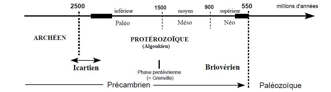
Le domaine ligérien est constitué d’une succession paléozoïque plus épaisse soumise à un métamorphisme polyphasé, dans cet ensemble seuls les schistes et micaschistes des Mauges seraient réellement précambriens donc nettement plus ancien (voir schéma).
Au cours des 100 millions d’années qui suivent, les événements géodynamiques vont se répéter : océanisation - fermeture par subduction - éventuellement obductions, puis collisions. Un des témoins de ce type de succession est le domaine ligérien , du moins la partie qui a échappé aux cisaillements,c'est à dire l'ensemble précambrien métamorphique des Mauges.
Suivez le sentier d'interprétation du site d'un kilomêtre, avec ses panneaux explicatifs et promener vous dans ces amoncellements de rochers… Commencer votre visite par le chemin barré d'une chaine prés du parking.
Pour valider votre visite sur le site et pour répondre aux exigences de groundspeak ,
vous devez envoyer à l'adresse ddl49@free.fr la réponse à une question dont la réponse se trouve sur les panneaux éducatifs du circuit:
-Question : Quel végétal est le plus ancien témoin du site ?
Joindre à votre log (PAS à vos réponses) une photo de vous, votre GPS, votre GC perso ou tout autre objet de geocaching aux coordonnées de la cache. Sans montrer les réponses bien sûr !
Les simples photos de paysage ne permettent pas de valider cette condition de log.
Cette tâche est obligatoire et autorisée par les guidelines mises à jour en juin 2019.
Bonne visite
|
|
This private property open to the public is a site listed since December 1995.
. The "cirque of Courossé" is a hollow between two hills where Evre river shy tributary of the Loire, gives a little look throat.
The cliff overlooking the Èvre river a height of 60 meters. The Evre river has incised and exposed outcrops of mica.
The dominant feature of the geologic plan of the ancient grounds of the Armorican Massif to Anjou and in Choletais, is constituted by big cross-functional tectonic accidents of direction boorishly is western with cisaillants uncouplings which made some slide with regard to the others of the groups different grounds.
The ligérien domain is constituted by a succession more thick paléozoïque subjected to a polyphase metamorphism, in this group only schists and mica-schists of the Mauges région would be really preCambrian thus sharply oldest (see plan).
During the 100 million years which follow, the geodynamic events are going to repeat: ocean invasion - closure by subduction - possibly obductions, then collisions. One of the witnesses of this type of succession is the ligérien domain, at least the part which escaped the cuttings, that is the metamorphic preCambrian Mauges region.
Follow the path of interpretation of the site of a kilomêtre, with its explanatory panels and walk you in these piles of rocks … Begin your visit with the road blocked by a chaine meadows of the parking lot.
To validate your site visit and meet the requirements of groundspeak, you must send it to ddl49@free.fr
The answer to this question is on the educational panels of the circuit:
Question : What plant is the oldest evidence of the site?
Attach to your log (NOT to your answers) a photo of you, your GPS, your personal GC or any other geocaching object at the posted coordinates. Without showing the answers of course !
The simple photos of the landscape do not validate this log condition.
This task is mandatory and allowed by the guidelines updated in june 2019.
Good visit
|
Bonne chance à toutes et à tous - Good luck everybody!