Kinder der Alpen

 Rhein und Bodensee sind Kinder der Alpen. Der Bodensee ist der drittgrößte Binnensee Europas.
Das Bodenseebecken wurde wesentlich während der Würm-Eiszeit durch den aus dem alpinen Rheintal austretenden Rheingletscher geformt, in dessen erodiertem Zungenbecken der heutige Bodensee liegt. Dieser kann insofern als würmglazialer Zungenbeckensee oder Gletscherrandsee bezeichnet werden.
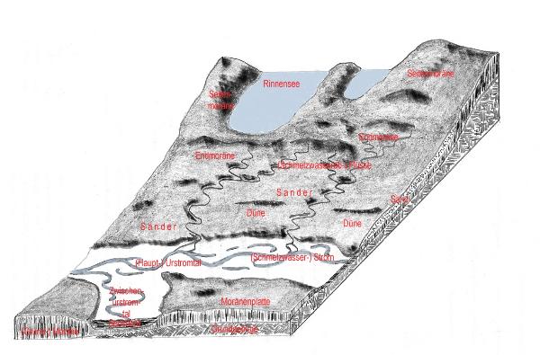 Ein Gletscherrandsee oder Gletscherendsee ist ein im Bereich der Grund- oder Endmoräne eines Gletschers entstandenes Gewässer. Eine Hohlform wird durch das fließende Eis der Gletscherzunge ausgeschürft. Die End- und Seitenmoränen bilden einen natürlichen Damm. Durch feine Sedimente werden der Boden und die Endmoräne derart abgedichtet, dass sich das Schmelzwasser des Gletschers in diesem Becken sammeln und nach dem Rückzug der Gletscherzunge einen See bilden kann. Heute werden diese Seen meist durch Regen- und Grundwasser gespeist, in den Alpen weiterhin vom Schmelzwasser der höher gelegenen Gebiete, so auch der Bodensee.
Um diesen Earthcache zu loggen, erfüllt bitte folgende Aufgaben:
1. Beantwortet folgende Fragen, deren Antworten sich aus der Tafel vor Ort ergeben, und schickt mir eure Antworten per Email. Die Logerlaubnis muss nicht abgewartet werden.
a) Wie weit reicht das Wassereinzugsgebiet laut der Tafel vor Ort ?
b) Wie hoch ist die durchschnittliche jährliche Pegelschwankung laut der Tafel vor Ort ?
2. Macht an den angegebenen Koordinaten ein Foto von euch und/oder eurem GPS, auf der die Tafel vor Ort zu sehen ist, und fügt das Foto eurem Log bei.
 Rhine and Lake Constance are children of the alps. The Lake Contance is the third biggest lake of Europe.
The Lake Constance basin was formed substantially during the Würm ice age by the Rhine glacier withdrawing from the alpine Rhine Valley, in whose eroded tongue basin the today's Lake Constance lies. This can be called würmglazialer tongue basin lake or lake of edge of glacier to that extent. A lake of edge of glacier or a glacier final lake is a waters developed within the range of the basic or terminal moraine of a glacier. A hollow form is out-dug by the flowing ice of the glacier tongue. The terminal moraine and moraines at the sides form a natural dam. The ground and the terminal moraine are sealed by fine sediments in such a manner that the meltwater of the glacier in this basin can collect itself and form after the retreat of the glacier tongue a lake. Today these seas by rain and groundwater are usually fed, in the alps further by the meltwater of the areas lain more highly, so also the Lake Constance.
In order to log this Earthcache, fulfilled ask the following tasks:
1. Answer the following questions, whose answers result from the board locally, and send to me your answers by email. Log permission does not have to be awaited.
a) How far does the water catchment area extend according to the board locally?
b) How highly is the average annual fluctuation in level according to the board locally?
2. Take at the indicated coordinates a photo of you and/or your GPS, on which the board is to be seen locally, and attaches the photo to your log.

Happy Caching
Team Null Peilung