 This is an EARTHCACHE -there is no box to find on this rock so there is no need to attempt a dangerous landing on it- While there is no requirement to do so, please try to add a photograph or photographs taken at the location to your log if you can. Also in your log, please describe how much swell (height of the waves) was there at the time of your visit, the weather conditions (particularly an estimation of the wind speed and direction) and if possible (NOT a logging requirement), a photograph of you with Rockall behind you. GPS in shot would be a bonus! Also include the name of your departure point for the voyage and its distance and bearing away from Rockall- to do this, make a GPS waypoint on the pier or embarkation point and get the figures while you're close to Rockall.
IMPORTANT: Via email to me, please estimate the size of Rockall in feet or metres. Height, area of the base at mean sea level and total volume above sea level. Assuming a mass of 2700Kg per cubic metre of Granite, estimate the weight of the portion of Rockall above mean sea level.
EDUCATIONAL: Is Rockall a lone spike of rock, or a part of a bigger underwater structure? I can't find this information online, so you will have to visit the site to answer the following question IN YOUR EMAIL TO ME- NOT IN THE ONLINE LOG PLEASE! At a distance of approx 100m (330ft) from Rockall, ask your skipper to take a depth-reading with sonar and let me know the depth of water and bearing to Rockall. Over time this will allow me to build up a 'picture' of the seabed or rocks around -and below- the Rockall we see above sea-level.
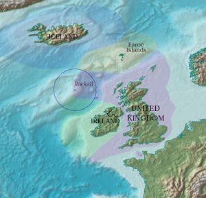
Rockall is the wind, rain and sea-eroded core of an extinct volcano, and is one of the few pinnacles of the surrounding Hellen’s Reef, along with Hasselwood Rock. Located 301.4Km (187.3 miles), or 162.7 nmi, west of the islands of St. Kilda (home to my GC10NMP - The Islands at the Edge of the World [St Kilda] cache off the west coast Scotland), and 430Km (267.2 miles) north-west of Donegal in Ireland. This bare granite quartz rock, formed by volcanic upheavals around 50 million years ago, is UNIQUE in Britain as its chemical composition identifies it as part of the North American continental plate, not the European plate.
The surrounding elevated seabed, which can be seen on Google Earth is called Rockall Bank, lying directly south of the Rockall Plateau. It is separated from the Western Isles by the Rockall Trough, itself located within the Rockall Basin. Anton Dohrn Seamount is a submarine elevation on Rockall Trough about halfway between Rockall and the Outer Hebrides; again, this can bee seen on Google Maps.
Rockall is mapped by the Ordnance Survey, but as it is officially outside the OSGB grid it is usually shown as an inset without gridlines on a mainland sheet, such as Explorer 454.
The first recorded person to set foot on the rock (not a requirement for this Earth Cache!) was Basil Hall, after whom the Hall Ledge near the top of Rockall is named. He landed from HMS Endymion on September 8th 1811 and later commented, "The stone of which this curious peak is composed is a dark coloured granite, but the top being covered with a coating as white as snow, from having been for ages the resting-place of myriads of sea-fowl, it is constantly mistaken for a vessel under sail."
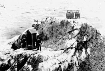 Rockall was claimed by Britain on September 18th 1955, for security reasons when the Benbecula rocket range was opened. A party from HMS Vidal landed by helicopter and applied a small brass plaque to the rock saying it was the Queen's. The Union Flag was hoisted above the rock and it was decreed that it would become a part of Harris, and subject to Scottish law. A navigation beacon was added in 1972, the same year that the United Kingdom formally annexed Rockall under the Island of Rockall Act - A publicity stunt, featuring two guardsmen and a sentry box was staged on the rock... When the possibility of oil being found below the rock was floated, the Irish Republic, Iceland and Denmark all laid claim to it. Thus ex-SAS man Tom McClean (John Ridgeway on some sites. Code name?) spent the best part of a month on the rock in 1985 to 'secure' Rockall for Britain. Greenpeace did something similar in the 1997, staying for 42 days and renaming Rockall 'Waveland' in the process.
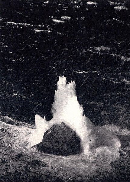
It is regularly washed over by large storm waves, particularly in winter. There is a small ledge of 3.5 by 1.3 metres (11 by 4 ft), known as Hall's Ledge, 4 metres (13 ft) from the summit, which is where both McClean/Ridgeway and Greenpeace placed their shelters.
Rockall is made of a type of granite that is relatively rich in sodium and potassium. Within this granite are darker bands richer in the alkali pyroxene mineral aegirine and the alkali amphibole mineral riebeckite. The dark bands are a type of granite that geologists named 'rockallite', although use of this term is now discouraged. In 1975, a new mineral was discovered on Rockall. The mineral is called bazirite, (chemical composition BaZrSi3O9), named after the elements barium and zirconium.
 Rockall was formed approximately 55 million years ago, when the ancient continent of Laurasia was split apart by plate tectonics. Greenland and Europe separated and the north-east Atlantic Ocean was formed between them.
Rockall is within the Exclusive Economic Zone (EEZ) claimed by the United Kingdom. In 1997, the UK ratified the United Nations Convention on the Law of the Sea and thus relinquished any claim to an extension of its EEZ beyond the islet. The remaining issue is the status of the continental shelf rights of surrounding ocean floor. These are the exclusive rights to exploit any resources on or under the ocean floor (oil, natural gas, etc.) and should not be confused with the EEZ, as continental shelf rights do not carry any privileges with regard to fisheries.
The rock's only permanent inhabitant macroorganisms are common periwinkles and other marine molluscs. Small numbers of seabirds, mainly fulmars, gannets, kittiwakes, and guillemots, use the rock for resting in summer, and gannets and guillemots occasionally breed successfully if the summer is calm with no storm waves washing over the rock. There is no natural source of fresh water.
Rockall is also close to the Darwin Mounds, deep-water coral mounds about 185 km (100 nmi or 115 mi) north-west of Cape Wrath.
So it's a small place with a big history! And that's even before I mention the many shipwrecks it's caused, or that legend has it that Rockall is the last remnant of Brazil - the Western Land of Eternal Youth. The Irish (well, some of them) say it's a pebble thrown into the sea by the Giant who built the Causeway, Finn McCool...
PLEASE REMEMBER! To back any claim of finding this Earth Cache (or claiming the rock as your own country) up, you are encouraged to provide photographic evidence of your trip and you must include the sea, weather and distance/bearing information requested above in your log, and email me with the required size and weight estimates as well as depth readings. Thank you.

Read more about The Historic Geocaches' campaign.
Please join us on Sun Aug 30th 2020 at
GC8C8C9 - GEOLYMPIX IV: STOWE 2020
"The Perfect Vision!"