Français :
Le pont d'Arc est un pont naturel, issu d’un méandre traversé par l'Ardèche, situé à 5 km de la ville de Vallon-Pont-d'Arc. Le pont a une largeur de 60 m pour une hauteur de 54 m et a été découpé par la rivière Ardèche. C'est un endroit réputé des canoéistes, car ils peuvent passer en dessous et même toucher la roche. Il est surnommé la « porte d'entrée naturelle » des gorges de l'Ardèche.
Histoire géologique de la Basse Ardèche
Trois temps géodynamiques permettent de comprendre l’histoire géologique de la Basse Ardèche où est situé ce Pont naturel : formation (genèse de la roche) ; déformation (dislocation) ; transformation (érosion).
Formation : Le massif calcaire s’est formé il y a -125 millions d’années lorsque la mer recouvrait la plus grande partie du Sud-est de la France. Au cours du temps, les différents dépôts de sédiments se transformèrent en roche dure (diagenèse) et donnèrent différentes strates suivant leur composition. Un massif sous-marin de 300 mètres d'épaisseur fut ainsi formé, composé des calcaires, lui-même peu à peu recouvert de sédiments.
Déformation : Quelques millions d’années plus tard (il y a ~110 millions d'années), la mer se retira peu à peu. L’eau continentale de surface s’est alors écoulée, traçant les méandres d'un cours d'eau. Puis, durant le tertiaire (il y a ~60 millions d'années), la croûte terrestre subit des déformations profondes qui conduisirent au soulèvement des Pyrénées et à la formation des Alpes. Le massif calcaire fut alors soulevé et fracturé.
Transformation : Lors de la dernière phase, le principal facteur d’érosion est l’eau qui a pu pénétrer le massif calcaire le long des fractures. Elle allie à la fois une action chimique par dissolution du calcaire et une action mécanique par frottements et usure de la roche lors du transport de matériaux.
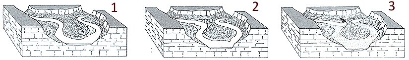
Dynamique fluviale de l'Ardèche
De nos jours encore, l'Ardèche façonne son cours et le modifie petit à petit, surtout au moment des crues quand le niveau de l'eau peut monter de 6 ou 8 mètres. Approvisionnée en eau par les affluents à l'amont des gorges et par les infiltrations du massif karstique, la rivière transporte alors des galets, du sable et des sédiments fins. L'érosion mécanique sur les parois est intense et accentue les courbes des méandres. Le fond de la rivière est aussi érodé, certaines zones plus friables étant plus facilement creusées. L'érosion plus rapide de la rive concave des courbes du cours d'eau, accentué par le dépôt de sable et de galets sur la rive convexe, aboutit à la création de méandres de plus en plus resserrés. L'érosion chimique (par infiltration) et mécanique que subit la paroi amène au recoupement du méandre, la rivière court-circuitant la boucle initiale : c'est le cas du Pont d'Arc.
Vous pouvez vous loguer sans attendre ma confirmation, mais vous devez m'envoyer les réponses en même temps que votre log :
S'il y a des problèmes avec vos réponses, je prendrai contact avec vous.
Les logs enregistrés sans réponses seront supprimés.
(une photo de vous ou de votre GPS sur place sera la bienvenue, mais n'est pas obligatoire).
Pour loguer un "found it" sur cette cache, vous devez :
1. Donner le nom de la grotte ornée découverte à proximité du Pont d'Arc en 1994.
2. De combien de mètres peut monter le niveau d'eau lors d'une crue dans les gorges.
3. Combien de gros blocs de pierre y a-t-il au niveau du belvédère.
English:
The Pont d'Arc is a natural bridge formed from a meander cut through by the Ardeche, located 5 km from the town of Vallon-Pont d'Arc. The bridge has a width of 60 m and a height of 54 m and was cut by the river Ardèche. It is a famous place for canoeists as they can pass underneath and even touch the rock. It is nicknamed the "natural gateway" to the gorges of the Ardeche.
Geological History of the Lower Ardèche
Three geodynamic times allow us to understand the geological history of the Lower Ardèche where this bridge is located ; firstly natural formation (genesis of the rock); secondly deformation (dislocation); and lastly transformation (erosion).
Natural formation: The limestone was formed here 125 million years ago when the sea covered most of south-eastern France. Over time, different sediment deposits turned into hard rock (diagenesis) and gave different strata according to their composition. A massive underwater rock bed around 300 meters thick was formed, composed of limestone, itself gradually covered with sediment.
Deformation: A few million years later ( ~ 110 million years ago), the sea gradually withdrew. The continental water surface then ran off, tracing the meanders of a watercourses. Then, during the Tertiary (~ 60 million years ago), the earth's crust was submitted to deep deformations, which led to the uprising of the Pyrenees and the formation of the Alps. The limestone was then raised and fractured.
Transformation: In the last phase, the main factor of erosion is water that penetrated the limestone along fractures. It combines chemical action by limestone dissolution and mechanical action by friction and wear when rock transporting materials.
Dynamics of the Ardeche River
Even today, the Ardeche is shaping its course and slowly changing, especially during floods, when the water level may rise by 6 to 8 metres. Supplied with water from tributaries upstream and massive infiltration of the limestone escarpment, the river then transports pebbles, sand and fine sediment. The mechanical erosion on the walls is intense and accentuates the curves of meanders. The river bottom is eroded, some areas being more brittle more easily washed away. The more rapid erosion of the concave side of the curves of rivers, accentuated by the deposition of sand and pebbles on the convex side, lead to the creation of tighter and tighter meanders. The chemical erosion (seepage) and mechanical erosion leads to closure of the meander, as the river bypasses the initial loop;; this is the case at the Pont D'Arc.
You can log the cache without my confirmation, but you should send me answers at the same time.
If there is anything wrong with your answers i will let you know.
Logs without sending answers will be deleted.
( a picture of yourself or your GPS on site would be welcome but is not mandatory ).
To log this earthcache you have to:
Email me with
a. The name of the painted cave discovered near the Pont d'Arc in 1994.
b. The number of metres that the water can rise during a flood in the gorge. If your answers are correct we will give you the permission to log the cache
c. How many big blocks of stone are there at the belvedere?