SSB - Captain Salem Avery House Museum Mystery Cache
SSB - Captain Salem Avery House Museum
-
Difficulty:
-

-
Terrain:
-
Size:  (regular)
Related Web Page
Please note Use of geocaching.com services is subject to the terms and conditions
in our disclaimer.
During the first challenge along the Star-Spangled Banner GeoTrail, over 400 first edition SSB geocoins were awarded. We would like to thank everyone who participated in the Star-Spangled Banner GeoTour. We are currently out of geocoins but stay tuned for other opportunities along the Star-Spangled Banner GeoTour!
Come on a journey to remember and commemorate the dramatic chain of events, people and places that led to the birth of our National Anthem.
The story of the Star-Spangled Banner was shaped by the events of the Chesapeake Campaign during the War of 1812. From February 1813 until February 1815, the Chesapeake Bay was the center of a fierce struggle between the British and Americans. Places and landscapes still exist today that provide a touchstone to the past. The trail traces events and related sites that figured prominently in the Chesapeake Campaign of the War of 1812 that have national significance, physical integrity, and the potential for contemporary recreation and interpretation.
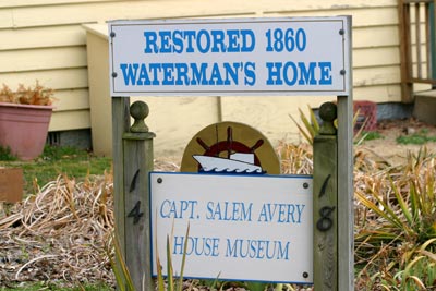
Captain Salem Avery was drawn to the Chesapeake region from Long Island for the bountiful fishing found in the estuary’s rich waters. In about 1859, he built a home along the West River in Shady Side, Maryland that offered easy access to the Bay. That house, restored by the Shady Side Rural Heritage Society to its original appearance, is now a museum, dedicated to the maritime culture and history of watermen along the Western shore. An outdoor display includes a modern boathouse and the locally built EDNA FLORENCE, a 1937 deadrise workboat. It is also interesting to note that the Captain Salem Avery House served for many years as headquarters for the National Masonic Fishing and Country Club, reflecting the recreational story that is also part of the Bay’s history.
During the War of 1812, this area was largely rural, home to people making a living in agricultural and on the water. From this spot, residents would have seen the maneuverings of the British and American fleets during the summers of 1813 and 1814. For example, in the summer of 1813 the British fleet had their sights set on the town of St. Michaels located directly across the Bay from Shady Side. On August 10, 1813, the fleet might have been spotted as it moved towards this port city on the eastern shore. Or perhaps the following year, Shady Side inhabitants tracked the activities of the British fleet as it prepared for the Battle for Baltimore (September 13-14, 1814). Overlooking the water on outdoor display is a War of 1812 cannon, placed many years after the end of the War in commemoration of the conflict. The cannon’s location may be the original home site, as erosion of the river bank has forced several relocations of the structure.
During the War, several different types of cannon were in use. Some were expressly designed for ships, a deadly specialty the Royal Navy was known for throughout the world. The British used these impressive weapons, including huge 18-pounders, to bombard American forts and attack the U.S. fleet throughout the Bay. Others were made for land engagements and could fire cannon balls or destructive grape shot – a new projectile that exploded mid-air releasing musket balls into opposing forces causing myriad injuries. Howitzers and mortars were also used during the War 0f 1812. At this time in history though, cannons were not too precise and much fighting was still done in relatively close quarters, using muskets, bayonets, pistols and knives.
The Captain Salem Avery House & Museum is open Sunday, 1-4pm, March to December or by appointment. The library is open on Monday, 12-3pm. Grounds open dusk to dawn. Programming such as lectures and educational programs on the Bay, conservation and Chesapeake heritage are held throughout the year.
Cache Info:
Finding this cache will require you to examine information about the historical artifacts on the grounds of the museum, not to mention allow you to see one of the best views that southern Anne Arundel County has to offer.
Begin your visit at the parking coordinates. From here proceed to the boat house immediately in front of you (the structure with the open front and the ‘deadrise’ boat sitting in it). On the sign that explains the history of this boat, there is mention of its original name. The total number of letters in this name (two words) equals B (Hint: the ‘sister’ of this boat has a similar name and is located at the Annapolis Maritime Museum, as mentioned on the sign).
Nearby there are many other signs that tell about the history of the Shady Side. One tells of the two farms that Capt. Avery owned. One was Avery Farm which was located where you are standing now. The other farm had a less illustrious name and was located where the Shady Side post office stands today (you may have noticed it off to your left as you drove towards the museum). The total number of letters in the name (two words) of this farm equals A (Hint: this information is on the sign “Seasons of the Waterman”).
Now continue around the western end of the house towards the shore line. Incidentally, the porch (to the right as you go around the building) is the main entrance to the museum. Near the flag pole on the shoreline you will notice a black cannon pointed towards the bay. (The coordinates for the cannon are listed as an additional waypoint below.) The sign explaining the presence of this cannon has the next two numbers you will need. The first is the location where Mr. Nowell found the cannon, the number of letters in this word equals C (Hint: the word you need immediately follows the word ‘surface’).
Next continue down onto the dock and find the sign that explains some of the creatures that have been found in the oyster garden. In one of the paragraphs there are three sets of words written in red. The number of letters in the first red word (minus the proceeding ‘A’) equals D (Hint: it’s not Cafeteria or Fort).
Finally, head back towards the museum stopping at the sailboat (this boat, named the Vanity is also listed as a waypoint below). On this sign you can read about this boat and the local boat race that used to be held in the area. When this boat finally lost, a new race came into being. This new race ends with a number. That number minus five results in a two digit number which equals E and F respectively (Hint: The first word in the name of the race is Chesapeake).
Once you have all of the necessary info, the final cache is located at N 38 50.ABC W 076 30.DEF.
Please take care when removing and replacing the cache. Please make sure it is out of sight when returning the cache to its hiding place. Good luck and thank you for your visit!

Thanks to VinceHayter for helping with this hide and to the Maryland Geocaching Society for assisting with this project!
Additional Hints
(No hints available.)