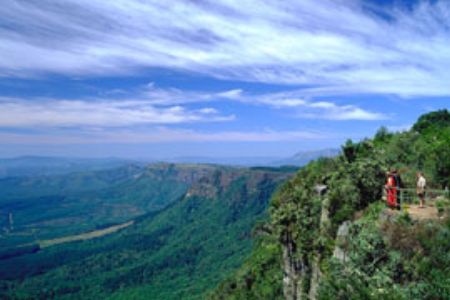
God’s Window
With magnificent views, canyons, rock formations and waterfalls, God's Window is truly an area of breathtaking scenic splendor. Gods Window is so called for the panoramic view of the Lowveld more than 900 m down into lush indigenous forest clad ravine. The majestic cliffs plunge over 700 meters to the Lowveld and the private game reserves which have made the area one of South Africa's main wildlife destinations. God's Window is a small part of a 250km long geological earthwork of sheer cliffs and majestic mountains. On a clear day it is possible to see over the Kruger National Park towards the Lebombo Mountains on the border with Mozambique. In fact, it seems as if one can see forever!
The geology of the Lowveld is organized into broad bands, oriented in an approximately north-south direction. The bands represent successive layers, once horizontal but now tilted downward towards the east by the immense forces that were associated with the shifting of the continents. So, a journey from east to west across the Lowveld Savannah is also a trip backward in time, from a mere 50 million years ago to the beginning of the world.
The evolution of the Lowveld landscape dates back to the break-up of Gondwanaland and the opening of the Mozambique Channel which initiated drainage to the Indian Ocean. At that time Karoo sediments and lavas covered the whole area. The greater part of the area was underlain with Achaean Old Granite and, in the case of the Murchison Range, even more ancient metamorphic rocks of the Primitive System.
Westwards, the old rocks are covered in turn by igneous and sedimentary rocks of the Witwatersrand and Dominion Reef systems. A subsequent tectonic uplift in the Miocene era and major warping that produced the Lebombo range in the east, accelerated erosion, plantation, scarp recession and drainage producing in time The Great Escarpment of the Drakensberg Mountain Range.
The Drakensberg Escarpment divides Mpumalanga into a westerly half consisting mainly of high-altitude grassland called the Highveld and an eastern half situated in low altitude subtropical Lowveld/Bushveld, mostly savanna habitat. The southern half of the Kruger National Park is situated in the latter region. The Drakensberg Mountains exceeds heights of 2000m in most places with this central region of Mpumalanga being very mountainous. These regions have alpine grasslands and small pockets of Afromontane Forests. The Lowveld is relatively flat with interspersed rocky outcrops. The Lebombo Rhyolite Mountains form a low range in the far east forming the border with Mozambique.
Some of the oldest rocks on earth are to be found in the Barberton area and these ancient greenstones and metamorphosed granites form the Crocodile River Mountains in the south-east of the province. The Lowveld is underlain by African Cratonic Basement rocks (Nelspruit Granite Suite) of ages in excess of 2 billion years. The Highveld is mostly Karoo Sequence sedimentary rocks of a younger, Carboniferous to Permian age.
In geomorphology, an escarpment is a transition zone between different physiogeographic provinces that involves a sharp, steep elevation differential, characterized by a cliff or steep slope. Usually escarpment is used interchangeably with scarp (from the Italian scarpa). But some sources differentiate the two terms, where escarpment refers to the margin between two landforms, while scarp is synonymous with a cliff or steep slope. The surface of the steep slope is called a scarp face. Scarps are generally formed by one of two processes: either by differential erosion of sedimentary rocks, or by vertical movement of the Earth's crust along a fault (faulting).
Most commonly, an escarpment is a transition from one series of sedimentary rocks to another series of a different age and composition. When sedimentary beds are tilted and exposed to the surface, erosion and weathering may occur differentially based on the composition. Less resistant rocks will erode faster, retreating until the point they are overlain by more resistant rock. When the dip of the bedding is gentle, a cuesta is formed. Steeper dips (greater than 30-40°) form hogbacks.
Escarpments are also frequently formed by faults. When a fault displaces the ground surface so that one side is higher than the other, a fault scarp is created. This can occur in dip-slip faults, or when a strike-slip fault brings a piece of high ground adjacent to an area of lower ground.
More loosely, the term scarp describes the zone between coastal lowlands and continental plateaus which have a marked, abrupt change in elevation caused by coastal erosion at the base of the plateau.
Earth is not the only planet where escarpments occur. They are believed to occur on other planets when the crust contracts, as a result of cooling.
Resources:
Absolute Astronomy
South Africa Travel
SA Venues
Kruger 2 Canyons
To log your find, answer the following questions and email them to me (do not post the answers in your log):
1. What is a cuesta and what is a hogback?
2. Determine the height above sea level at the co-ordinates (if your GPS receiver doesn’t have an altimeter, you may have to use a topographic map).
3. How long (approximately) is the trail through the natural rainforest?
4. Uploading photos to the cache page and to allocate a favorite point is the best way to say thank you to the cache developer and to encourage others to visit the location but is only optional.
Note:You can sent me your answers in either Afrikaans or English.