Ocean's Eye
- Meerauge
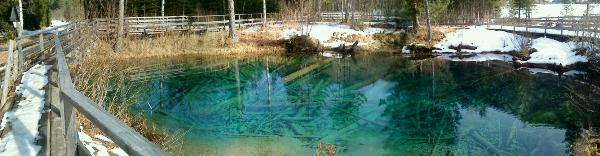
Das Meerauge ist eines von mehreren kleinen
Stehgewässern mitten im Bodental. Interessant ist es durch seine
besondere leuchtend türkis-blaue Farbe und die immer wieder
aufsteigenden Luftblasen. Das Wasser ist sehr sauber; es befinden
sich fast keine Algen, kaum Plankton und kaum Nährstoffe im Wasser.
Dieser Faktor ist gemeinsam mit dem speziellen Chemismus des
Wassers und dem Lichteinfall verantwortlich für die leuchtende
Farbe.
Im Frühjahr 2007 begann die Stadtgemeinde Ferlach in Kooperation
mit der Carnica-Region Rosental, der Arge Naturschutz und den
Grundeigentümern die Erreichbarkeit des Meerauges in einer
naturschonenden Weise auszubauen. Die Besucher können nun auf einem
breiten Holzsteg das Meerauge bequem erreichen.
Entstehung
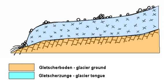
Die Entstehung des Meerauges ist auf die letzte Eiszeit, die
sogenannte Würm-Eiszeit, zurückzuführen. Neben dem mächtigen
Draugletscher bildeten sich auch in den Karawanken lokale
Gletscher, deren größter vermutlich der Bodental-Gletscher war.
Dieser reichte vom Vertatscha-Kar fast 6 Kilometer talauswärts bis
knapp vor Windisch-Bleiberg. Der Gletscher bedeckte mit einer
Breite von 2 Kilometern und einer Tiefe von 120 bis 250 Metern den
gesamten Talboden. Auf seiner Oberfläche transportierte er Geröll
von den Karawanken zu Tale.
Mit der zunehmenden Erwärmung vor ca. 12.000 bis
10.000 Jahren zog sich der Bodental-Gletscher schrittweise zurück.
Dabei wurden die Geröllmassen abgelagert und bedeckten den
ausgehobelten Talboden. Im Geröll waren auch abgesprengte
Toteisbrocken eingeschlossen. An der Gletscherzunge entsprang ein
Gletscherbach, der Vorgänger des heutigen Bodenbaches, der einen
See im eisfreien Vorfeld speiste. Der See wurde im Laufe der Zeit
jedoch vom Gesteinsmaterial allmählich zugeschüttet.
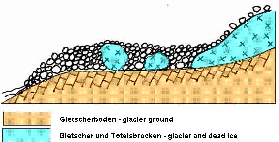
Gleichzeitig mit dem Rückzug der Gletscherzunge trug die
Wassererosion (Regen und Schneeschmelze) das Geröll oberflächlich
ab und die Toteisbrocken gelangten ans Tageslicht. Eine Erdkrume
begann sich zu bilden, die erste Vegetation entstand.
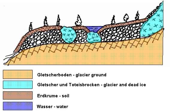
Langsam schmolz nun auch das Toteis und die
zurückbleibenden Bodenlöcher füllten sich mit dem in den
Schwemmschuttschichten des Talbodens strömenden Grundwasser. Die
Erdkrume verfestigte sich und es entstanden dichte Wälder und
später gerodete Wiesen.

Das Meerauge ist das größte dieser
zurückgebliebenen Bodenlöcher. Ähnliche, kleinere Löcher mit
aufsteigenden Grundwasserquellen treten nicht nur in unmittelbarer
Nähe des Meerauges auf, sondern öfters auch verstreut in den
umliegenden Wiesen.
Die Sage
Im Volksmund heisst es, dass das Meerauge unterirdisch mit anderen
Gewässern, ja, sogar mit dem Meer verbunden sein soll.
So soll einmal dem Bodenbauer bei der Heuernte das voll beladene
Ochsengespann durchgegangen und in das Meerauge gestürzt sein. Als
der Bauer wenige Minuten später am Ufer ankam, konnte er nur noch
tatenlos zusehen, wie die Heufuhre samt den Ochsen versank. Mehrere
Wochen später soll man in einem See auf der anderen Seite der
Karawanken das Joch des Gespanns schwimmend gefunden haben.
Logbedingungen
In der Nähe des Meerauges gibt es zwei Informationstafeln.
Informationstafel 1:
N 46° 28.242
E 014° 13.150
Informationstafel 2 (bei den Headerkoordinaten):
N 46° 28.299
E 014° 13.077
Bei diesen Informationstafeln wirst du die Antworten für folgende
Fragen finden:
- In welchem See tauchte das sagenhafte Joch des Ochsengespanns
nach einigen Wochen wieder auf?
- Aus welcher Holzart ist der Holzsteg, der den Waldboden vor
Erosion schützen soll?
- Wie lang ist der Holzsteg und wie viele Brücken umfasst
er?
- Wann genau war die Eiszeit, in der das Meerauge entstanden
ist?
- Wie heißt das größere der zwei kleinen Becken nördlich des
Meerauges?
Nachdem du die Fragen beantwortet hast, folge dem Holzsteg rund um
das Meerauge, genieße die Natur und schieß ein Foto mit dir und
deinem GPS, mit dem Meerauge im Hintergrund. Dieses Foto poste
bitte mit deinem Logeintrag.
Bitte sende die Antworten per Mail an silverray@gmx.at. Falls
mit den Antworten etwas nicht in Ordnung ist, melde ich mich bei
dir! Logs ohne Mail oder Foto werden nicht akzeptiert und im
Nachhinein gelöscht!
Referenzen
Tuschar, Hans M.: "Meerauge/Jezerce", in
http://www.naturerlebnis-bodental.at/ (link).
Krainer, K. und Schiegl, R., Arge NATURSCHUTZ, September 2007.
English Description:
The Ocean’s Eye (in German: Meerauge) in
the Bodental is a glacial remnant of a pond with a bright turquoise
blue color and ascending air bubbles. The bright color results from
the combination of the following factors: light incidence, special
chemism, and the fact that the water is very clean (almost no
algae, plankton or nutrients in the water). You can access the pond
easily on a footbridge over the forest soil.
Development
The Ocean’s Eye was formed in the last ice age, the Würm ice
age. At this time, there were several local glaciers in the
Karawanken mountains, one of them was the glacier in the Bodental.
This glacier reached from the Vertatscha-Kar almost six kilometers
down to Windisch-Bleiberg. The complete valley floor was covered
with ice, with a width of two kilometers and up to 250 meters high.
The glacier carried boulder from the Karawanken to the valley.
After the ice age, 12.000 to 10.000 years ago,
the big glacier melted and the boulder was sediment at the valley
floor. In the boulder chunks of dead ice remained. At the glacier
tongue a small subglacial brook was formed (a predecessor of
today's Bodenbach), that supplied a lake in the ice-free zone. This
lake filled up with boulder in the course of time.
At the same time the valley was superficially cleared from the
boulder by water erosion (rain and snow melting), revealing the
chunks of dead ice. Soil was formed and the first vegetation came
to existence.
The dead ice melted slowly and the remaining
hollows filled with ground water. The soil hardened and the
vegetation changed to woods and cleared meadows later.
The Ocean’s Eye is the biggest of these
remaining pools. Similar but smaller pools with ascending sources
of ground water can be found near the Ocean’s Eye, but are
also scattered in the surrounding meadows.
The Myth
An old myth tells that the Ocean’s Eye is subterraneously
connected with other bodies of water, even with the sea.
Once, a fully loaded harnessed bullock team bolted and fell into
the Ocean’s Eye. The farmer could not help them, and the
harnessed team with the hay went to the bottom of the pond. It is
said that the yoke of the harnessed bullock team was found in a
lake at the other side of the Karawanken mountains a few weeks
later…
Logging Requirements
Near the Ocean’s Eye you will find two information
boards.
First information board:
N 46° 28.242
E 014° 13.150
Second information board (at the header coordinates):
N 46° 28.299
E 014° 13.077
At these information boards you will get the information for
answering the following questions:
- According to the myth, in which lake was the yoke of the
harnessed bullock team found after a few weeks?
- Which kind of wood is the footbridge protecting the forest soil
from erosion made of?
- How long is the wooden footbridge and how many bridges do you
cross?
- Name the duration of the ice age, in which the Ocean’s
Eye was formed.
- How is the bigger of the two small northerly ground water
source pools called?
Note that the information board presents a German description only.
In case there is no German speaking person on-site, you may skip
the first and the last question and estimate the third one.
After answering the questions, follow the trail around the
Ocean’s Eye, enjoy the nature, and take a photo of you with
your GPS and the pool in the background. Please post this photo
with your log entry.
Please send your answers per mail to silverray@gmx.at. You may
log your visit online right away, but make sure that your log
contains a photo, showing you and your GPS near the given
coordinates in the header, with the Ocean's Eye in the background!
I will check your answers and get only in touch with you if
something is missing or not correct.
Logs with incomplete or incorrect anwers or logs without photos are
not accepted and will be deleted!
References
Tuschar, Hans M.: "Meerauge/Jezerce", in
http://www.naturerlebnis-bodental.at/ (link).
Krainer, K. und Schiegl, R., Arge NATURSCHUTZ, September 2007.
|