[DEUTSCH]
Die drei Besonderheiten am Drei-Flüsse-Eck
Nr. 1 Geologie - Antezendenter Durchburch der Donau
Die Donau hat sich hier während der Hebung des bayerischen Waldes
im Spät-Tertiär und Quartär in das kristalline Grundgebirge
eingeschnitten. Die Folge war die Ausbildung eines antezedenten
Durchbruchstals. In diesem Fall schneidet sich der Fluss aktiv, mit
der tektonischen Hebung Schritt haltend, in den aufsteigenden
Gebirgskörper ein. Die Donau schuf dadurch ab Vilshofen bis weit
über Passau hinaus ein beeindruckendes Flusstal. Die Tiefe des
Durchbruchtals beträgt im Passauer Raum etwa 100 Meter.
Definition Antezedentes Durchbruchstal:
Antezedente Durchbruchstäler sind Täler von Flüssen, deren
Laufrichtung schon vor dem Einsetzen der Gebirgshebung feststand.
Mit der tektonischen Hebung einhergehend schnitt sich der Fluss in
das aufsteigende Gebirge ein, anstatt sein Flussbett zu verlagern.
Geologen bietet ein Durchbruchstal interessante Sichten auf die
Gesteine und die Verbiegungen ihrer Schichten seit der
Gebirgsbildung.

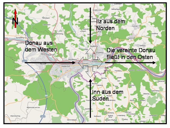
Nr. 2 Geographie - Die vier Himmelsrichtungen
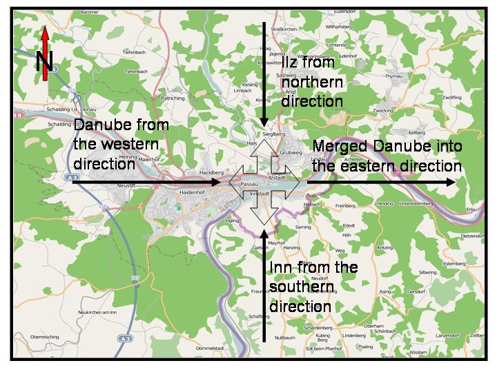
Dies ist die weltweit einzige Stelle an der 3 Flüsse aus drei
unterschiedlichen Himmelsrichtungen zusammen fließen und in die
vierte Richtung gemeinsam weiter fließen. Aus Norden die Ilz, aus
Westen die Donau und aus Süden der Inn, nach Osten als gemeinsamer
Donaustrom.
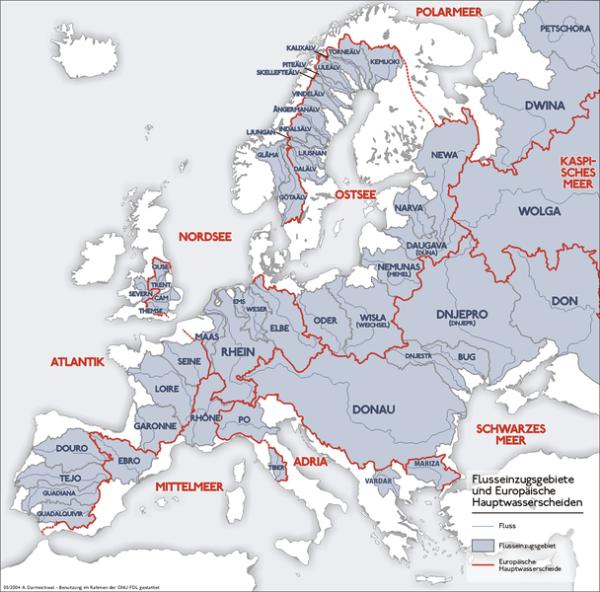
Dieses außergewöhniche Phämomen basiert darauf, dass die Donau
ziemlich genau in der Mitte zwischen zwei Hauptwasserscheiden
liegt. Das nächste Bild zeigt die Hauptwasserscheiden von
Europa.
Definition Wasserscheide:
Eine Wasserscheide ist der Grenzverlauf der Einzugsgebiete für das
abfließende Niederschlagswasser zweier oder mehrerer Flüsse, also
die Grenzen benachbarter Flusssysteme. Im bergiger Landschaft meist
entlang von topografischen Höhen. In ebenenem Gebiet sind diese
Grenzen meist nicht sichbar. Wasserscheiden sind wichtige
geografische Linien und oft auch politische Grenzen.
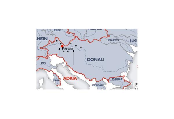
Hier die exponierte Lage der Donau, die dieses Drei-Flüsse-Eck mit
den vier Himmelrichtungen begründet. Die Donau liegt in der Mitte
von zwei Hauptwasserscheiden. Die nördliche Wasserscheide bewirkt,
dass die Ilz von Norden zufließt. Die südliche Wasserscheide
bewirkt, dass der Inn von Süden zufließt. Die Donau bildet quasi
den Falz zwischen beiden Erhebungen, so dass hier das Wasser von
West nach Ost fließen kann.
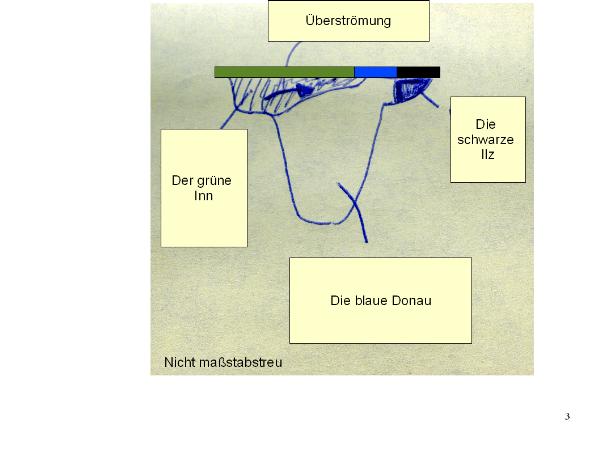
No. 3 Physik (Strömung) and Biologie (Wasser)- Die Farben des
Flusswassers
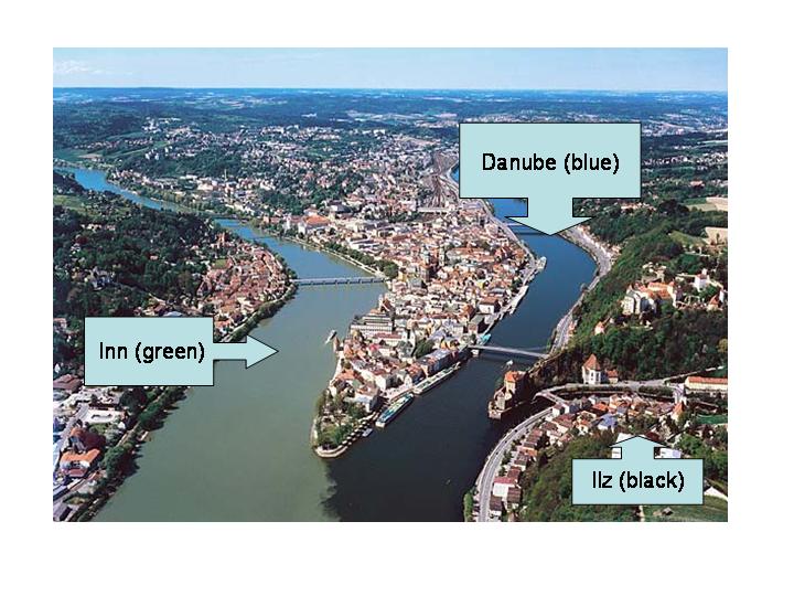
Das Wasser des Donaustroms setzt sich aus drei Farben zusammen. Das
Wasser des Inns ist grün, das das Donauwasser ist blau und das
Wasser der Ilz ist schwarz. Noch ein längeres Stück nach dem
Zusammenfluss lassen sich die drei Farben erkennen. Auffallend ist
dabei, wie stark das grüne Wasser des Inns das Wasser der Donau
beiseite drängt. Dies hängt neben der zeitweise sehr großen
Wassermenge des Inn, hauptsächlich mit der stark unterschiedlichen
Tiefe der beiden Gewässer (Inn: 1,90 Meter / Donau: 6,80 Meter)
zusammen – „der Inn überströmt die Donau“

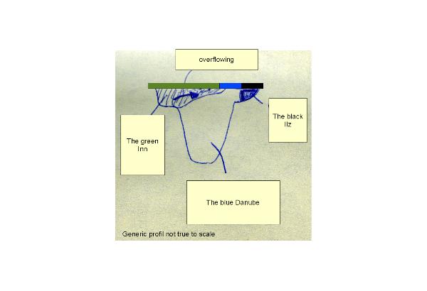
Im Querprofil ist das deutlich zu erkennen. Der Inn auf der linken
Seite ist nicht sehr tief, dafür aber deutlich schneller als die
Donau. So überfließt der Inn das langsamere Donauwasser.
Die Flüsse
Die Donau - zweitgrößter Strom Europas
Die Donau ist mit ca. 2800km Länge nach der Wolga der zweitgrößte
Strom Europas. Sie durchquert Europa von West nach Ost. Die Donau
entspringt im Schwarzwald und fließt durch neun Staaten:
Österreich, Slowakei, Ungarn, Kroatien, Serbien und Montenegro,
Rumänien, Bulgarien, Moldawien und Ukraine. Sie mündet in das
Schwarze Meer.
Der Inn - ein Dreiländerfluss
Der Inn entspringt im Lunghiner See oberhalb des Malojapasses in
der Schweiz. Er fließt durch Tirol (Österreich) und Oberbayern
(Deutschland). Er war eine bedeutende europäische Wasserstrasse für
verschieden Handelsgüter, ist aber heute nicht mehr
schiffbar.
Die Ilz - ein Fluss des bayrischen Walds
Die Ilz entspringt im bayrisch-böhmischen Grenzgebiet unweit vom
Rachelsee. Bis zum Mündung im Passau hat sie eine Länge von 60km.
Früher diente sie als Handelsweg nach Böhmen. Heute ist sie für
ihre Naturschönheit bei Wanderern sehr beliebt.
Weitere Infos zu den Flüssen findet ihr unter:
http://de.wikipedia.org/wiki/Donau
http://de.wikipedia.org/wiki/Inn
http://de.wikipedia.org/wiki/Ilz_(Fluss)
Um diesen Cache zu loggen sind folgende Bedingungen zu
erfüllen:
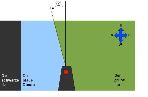
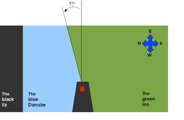
1.) Begib Dich zu Position an den oben genannten Koordinaten (roter
Punkt in der Skizze). Schau nach Osten (wie in der Skizze
dargestellt). Nun schätze, wie groß der Winkel ist in dem der Inn
die Donau überströmt.
Ist der Winkel zwischen 0° und 90°, dann ist xx=rot
Ist der Winkel zwischen 91° und 180°, dann ist xx=blau
Ist der Winkel zwischen 181° und 270°, dann ist
xx=gelb
Ist der Winkel zwischen 271° und 360°, dann ist
xx=lila
2.) Was ist der geologische Grund für die grüne Farbe des
Inns?
Ist es das Plankton, dann ist yy=esp
Ist es eine optische Täuschung, dann ist yy=ige
Ist es das Gletscherwasser, dann ist yy=erw
Ist es Grünspan, dann ist yy=ems
3.) Was ist der geologische Grund für die schwarze Farbe der
Ilz?
Sind es Klärabfälle, dann ist zz=ferd
Ist es eine optische Täuschung, dann ist zz=lerd
Ist es Moorwasser, dann ist zz=olf
Kommt er aus dem schwarzen Meer, dann ist zz=sand
4.) Mach ein Foto von Dir, Deinem GPS und dem schönen Ort und hänge
es ins Log. Alternativ geht es auch per Mail.
Für die Logfreigabe bitte einfach ein Mail an folgende
Adresse:
earthcache.gc21781.xxyyzz@googlemail.com
Viel Spaß an der schönen blauen Donau!
[ENGLISH]
Three Special Characteristics of the
Three-River-Corner
No. 1 Geology - Danubes antecedent transverse valley
In the late Tertiary and the Quaternary, the Danube carved it's way
through the cristalline structure of the basement. At the same
time, the Bavarian Forest elevated tectonically. The result was the
formation of a antecedent transverse valley. Here in Passau, the
geological tranverse valley has a depth of about 100m.
Universal Definition of Antecedent Transverse Valley:
Antecedent transverse valleys are valleys of rivers, whose flow
directions are fixed before the tectonical elevation of the
basement starts. That means, instead of the relocation of the river
caused by the elevation, the river carves it's way into the
basement. For geologists, a transverse valley is always a good
chance to explore the layers of stone.
No. 2 Geography - The Four Points of the Compass
This is the unique worldwide site where three rivers from three
different directions meet at one point in a confluence and continue
their journey together as one big river called the Danube. The Ilz
from the north, the Danube from the west and the Inn from the
south. After they have joined, they continue in the fourth
direction, the east.
This phenomenon is caused by the exposed location between two main
drainage divides. In the next image the main European drainage
divides are mapped.
Universal Definition of Drainage Devides:
A watershed is the line separating neighbouring drainage basins. In
hilly country, the divide lies along topographical peaks and
ridges, but in flat country (especially where the ground is marshy)
the divide may be invisible – just a more or less notional
line on the ground on either side of which falling raindrops will
start a journey to different rivers, and even to different sides of
a region or continent. Drainage divides are important geographical,
and often also political boundaries.
Here you can see the exposed situation of the Danube that enables
this specific "Four-Directions-Place". It lies in the middle of two
watersheds. The northern watershed makes the Ilz run from north to
the Danube. The southern watershed makes the Inn run from south to
the Danube. The Danube builds the fold between the two watersheds
and runs from west to east.
No. 3 Physics (flow) and Biology (water)- The Colours of
Water
The water of the merged river Danube is composed of three different
colours. Inn's water is green, Danube's water is blue and the water
of the Ilz is black. You can see the different colours for a long
distance in the river Danube after the confluence. Remarkably, the
green water of Inn pushes the blue water apart. This phenomenon
depends on the speed of Inns water on one side and on the wide
difference of the rivers depth on the other side (Inn: 1,90 meters
/ Danube: 6,80 meters) – „the Inn overflows the
Danube".
Please watch the profile to understand this phenomenon. The Inn on
the left side is not so deep, but it's faster than the Danube. So
the water of the Inn overflows the water of the Danube.
You want to know the reason why the three rivers have three
different colors? It's up to you to find out!!!
The Rivers
The Danube - the 2nd Largest River in Europe
With the length of 2800km the Danube is the second largest river
(behind the Volga) in Europe. It crosses and connects Europe from
west to east. After Germany the Danube borders nine states:
Austria, Slovakia, Hungary, Croatia, Serbia and Montenegro,
Romania, Bulgaria, Moldavia and the Ukraine
The Inn - a river of Three Countries
The Inn has a length of about 520km until it reaches Passau. It has
its source in Lake Lughin above the Maloja pass in Switzerland. It
flows through Tyrol (Austria) an southern Bavarian (Germany). The
Inn used to be an important waterway, but it is not navigable any
longer today.
The Ilz - a River of the Bavarian Forest
The Ilz has its source in the forest which forms the border between
Bavaria and Bohemia, not far from Lake Rachel. It ends in Passau
after 60km. It was used for transport for trade to Bohemia. Today,
walkers enjoy the romantic atmosphere along this riverside.
For further details about the Danube please visit:
http://en.wikipedia.org/wiki/Danube
For further details about the Inn please visit:
http://en.wikipedia.org/wiki/River_Inn
For further details about the Ilz please visit:
http://en.wikipedia.org/wiki/Ilz
To log this cache, please fulfill the following
requirements:
1.) Go and find the position (red dot in the figure) at the
coordinates above. Set your direction of view to east (like
symbolized in the figure). Now make an estimation. What is the
angle of the overflow of the Inn over the Danube?
Angle in the range between 0° and 90°, then xx=rot
Angle in the range between 91° and 180°, then xx=blau
Angle in the range between 181° and 270°, then xx=gelb
Angle in the range between 271° and 360°, then xx=lila
2.) What is the geological reason of Inn's green water?
It's caused by plankton, then yy=esp
It's an optical illusion, then yy=ige
It's glacier water, then yy=erw
It's green rust, then yy=ems
3.) What is the geological reason of Ilz's black water?
It's sludge, then zz=ferd
It's an optical illusion, then zz=lerd
It's marsh water, then zz=olf
It comes from the black sea, then zz=sand
4.) Send a picture to us of yourself and your gps device at the
spot. Alternatively attach it to the log.
To log this cache please send an email to:
earthcache.gc21781.xxyyzz@googlemail.com
Have fun at the beautiful blue Danube!