PLEASE BE AWARE BEFORE YOU READ ANYTHING ELSE: ACCESS TO THIS CACHE IS POTENTIALLY DANGEROUS - YOU WILL HAVE TO TRAVERSE CLIFFS USING 'VIA FERRATA' CHAINS BOLTED INTO THE ROCKS, THERE IS ALSO A RISK OF YOU BEING TRAPPED BY THE TIDE IF YOU DO NOT GO AT THE CORRECT TIME OF DAY (tide time link is included below) IF YOU ARE IN ANY DOUBT ABOUT YOUR ABILITY TO COMPLETE THE SCRAMBLING ON THIS ROUTE THEN PLEASE DO NOT ATTEMPT THIS CACHE
The tide times for the area can be found here:
http://www.eesc.org.uk/content/forth-tide-times-leith-scotland.html Please ensure when working out tide times that you follow the instructions on the page about how much time to add or subtract from the given tidal point, the terrain is mostly rocky but, with care and common sense it can be a very enjoyable experience
You will need to visit 3 places on this walk to claim this cache, it will probably take you around an hour to complete the walk, or a little more if you spend time exploring - which is reccomended!
Now that the warnings are out of the way, we can proceed to the main event..
Kincraig Points' Volcanic beginnings
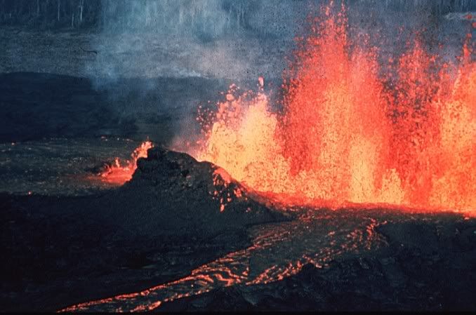
here at Kincraig Point, hidden away below the towering cliffs is a very unusual and spectacular landscape, one created by long extinct Volcanoes.. Around 415 million years ago, Fife and Tayside had towering volcanoes that erupted magma - molten rock - from great depths in the Earth’s crust, this through various processes has formed the landscape as you see it here today
The story at Kingcraig starts in a geological period between 3360-300MA know as the Carboniferous when Scotland sat astride the equator. Warm shallow seas were fringed with coral reefs offshore with large river systems and tropical rain forests growing on extensive coastal plains. In the forests trees died to fall and rot in shallow waters building to the thick coal seams that was heavily mined here in Fife. Cycles of sea level rise and fall caused inundation of the coast with water and the preservation of the corals, sands from the rivers and the coal seams. These can all be seen in the bedded (layered) rocks along the foreshore to the east of Kingcraig

The rocks do not lie today in the orientation that they were laid down, that is horizontally, rather the layers or beds are turned, twisted and folded as a result of massive forces moving the continental plates thus squeezing and bending the rocks after they had been formed. These are the rocks of the bay, rocks that are quite soft and more easily eroded as seen here on this coastally eroded section below: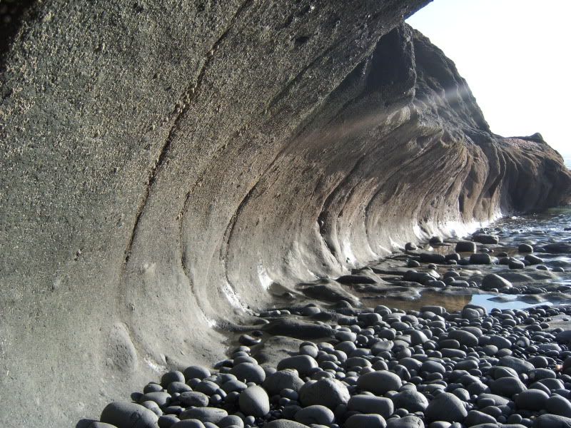
The magma (molten rock) that was forced up under great pressure, shattering, smashing and carrying up with it the surrounding rocks. This smashed rock or "breccia" was often hurled to great heights out of the volcano covering the surrounding countryside with ash, magma and bombs of more solid rock. Many of these 'bombs' can be seen in the rocks near the start of the Chain Walk
The Volcanoes' core
There is ample evidence of the volcano itself, its origin from great depths in the earth.this is evident from what remain s here, the cetrain areas that have not eroded due to the minerals they contain within the rock, minerals that make the rock very hard and resistant to the forces of erosion. As the volcanic activity in Fife died away, the centre core of the volcano, through which it fed the boiling magma to the surface, remained frozen in time, solidified in place to undergo slow cooling resulting in the what you see at the given coordinates today..
The Devils Tower
A truly stunning peice of geologic history, huge towering columns of basalt, often in hexagonal shapes, also known as 'organ pipes' due to their appearance as such, the most famous example of these being at the Giants Causeway in Northern Ireland, The Devils tower is composed of distinct columns of five or six-sided basalt rock, formed from cooling lava, hardening from the outside edges inwards. If a great deal of water is present during this cooling process, it will seep into cracks in the cooling lava, turn into steam, and re-condense. This process, known as re-fluxing, causes the shape and distinctiveness of each basalt column.
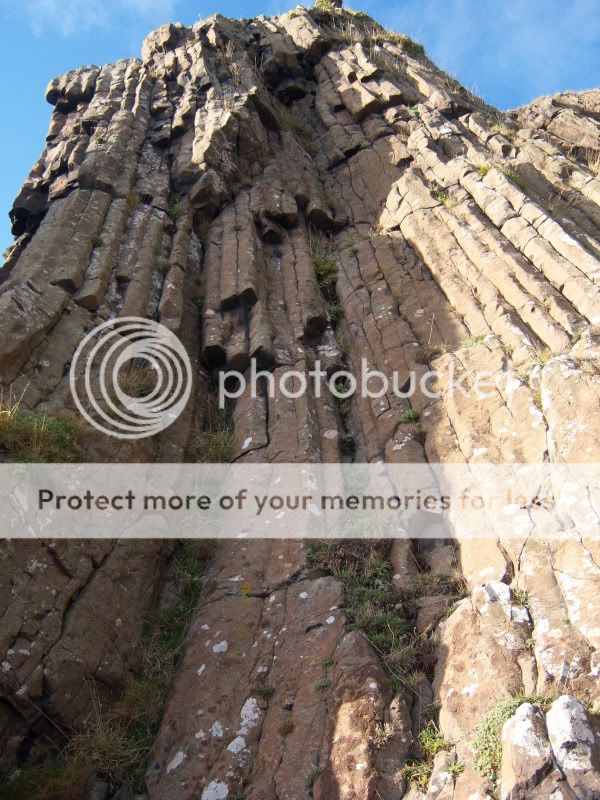
Due to the columns inclination it is thought that the lava occupied a conical depression before cooling.
Further along the walk there is a small cave, Doo's cave as it is known, named after the residents (rock doves) that nest here. This cave goes into the cliffs about 15 metres or so, at low tide you will be able to walk inside and explore, at high tide you won't be able to get into it, however it is best to do this cache at low tide to maximise your exploring potential!
Incase you have been wondering, this is what you will need to climb and descend to get around this cache:
Hold on tight !..

Hopefully I have whetted your appetite to have a go at this, or if you have done it already to make a return visit!
To log this Earthcache please complete the following tasks
1.Please take a photograph of yourself / GPS at the Devils Tower
2.Estimate how high it is and approx what angle the columns sit at
3.At the second listed waypoint take a photograph of the eroded volcanic rock and describe the texture of it around the base.
4.Finally at the 3rd waypoint take a picture of the 'Doo Cave' and tell me roughly how high the entrance is.
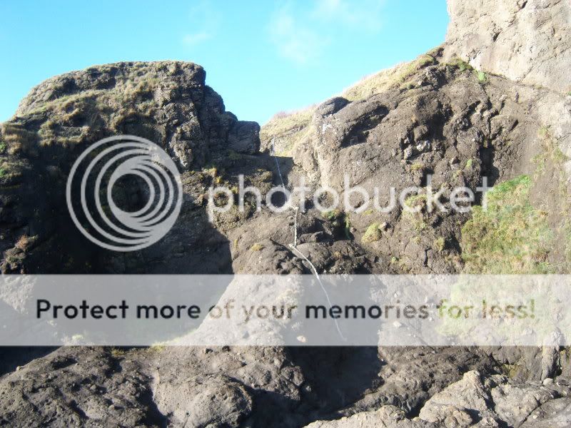
There are numerous other features on the chain walk which I haven't included as requirements as it would simply be too big, you will see many unusual rock formations, a natural arch, and the remains of Macduff's cave, if you wish to include photo's please do as I love to see them in the logs
Please note: it is possible to do this cache from either direction, just simply reverse the waypoints, the climbs aren't really any harder one way or the other, I hope you have fun discovering this area and learning how it was created
PLEASE NOTE: I receive a very high number of Earthcache emails, I can’t reply to them all otherwise I’d be doing nothing else all day, as has always been the case there is no need to await a reply from me regarding your answers…. However due to numerous people thinking they can just log these caches without emailing any answers, and/or completing the required tasks these will be picked up, and the logs will be deleted without further communication. To facilitate this Please email your information either before, or AT THE SAME TIME OF LOGGING THE CACHE, Thanks.