Skurugata EarthCache
-
Difficulty:
-

-
Terrain:
-

Size:  (other)
Please note Use of geocaching.com services is subject to the terms and conditions
in our disclaimer.
Sv: Cahcen är satt på parkeringen. Du måste gå ner i sprickan för att fotografera.
Eng:Earth cache location is the parking lot. You need to go in the gorge to take pictures.
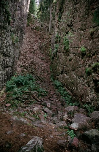
Swedish: Skurugata är en ovanlig geologisk bildning i Eksjö kommun i Jönköpings län i Sverige. Skurugata är en omkring 800 meter lång klyfta i berget som är mellan 7 och 24 meter bred. Det finns flera liknande skuror på andra ställen i östra Småland, varav Skurugata är den största. Den vanligaste förklaringen är att klyftan skapats av en isälv vid inlandsisens smältning. Andra tror att klyftan är en spricka i berggrunden eller en gravsänka. Berget i området och stenarna på klyftans botten, utgörs av gråbrun och mörkbrun porfyr med inlägg av kvarts och röd fältspat. Porfyt kommer från grekiskans "porphyry" som betyder purpur. De branta bergväggarna är på vissa ställen väldigt höga. Det finns ett antal olika teorier om hur klyftan en gång bildades. Även varma sommardagar brukar det vara svalt i botten av klyftan och vissa år har högar av snö och is legat kvar långt in på sommaren. Tidigt på säsongen och efter kraftigt regn, kan delar av sprickan vara vattenfylld. Området kring Skurugata är ett naturreservat och i området finns en stig, cirka 2km lång, som leder genom hela sprickan och upp på bergstoppen Skuruhatt. I mitten av sprickan finns en sten som går att lyfta bort och bakom finns en gästbok, exakt plats markeras av en skylt i klippväggen En skröna säger att en bössa finns gömd nånstans i Skurugata som skulle ha gömts av en tjuv som kallades "Tjuva-Jösse". Det sägs att den som hittar bössan kommer få stor framgång.
För att logga denna cache ska du:
1. Ta en bild av dig själv och din gps inne i Skurugata. Du väljer själv platsen men båda sidor av klippväggen ska synas.
2. Klippväggarna är höga. Uppskatta i meter det högsta stupet i formationen.
3. Vad heter toppen med vacker utsikt som finns i anslutning till Skurugata?
Skicka mig svaren på fråga 2 och
3. Om du har foton (frivilligt) kan du logga direkt. Maila mig svaren så hör jag av mig om det inte stämmer.
English: Skurugata is a rock canyon in southern Sweden, an 800 meter long gorge which runs 7 to 24 meters wide. There are several different theories for its origin but the more popular theories claims that it was created by melting ice during the he last glacial period or by parallel faulting. The mountain around the gorge itself, and the stones spread across its bottom, consist largely of grey-brown and dark-brown porphyritic rock. Porphyry is a variety of igneous rock consisting of large-grained crystals, such as feldspar or quartz, dispersed in a fine-grained feldspathicmatrix or groundmass. The larger crystals are called phenocrysts. In its non-geologic, traditional use, the term "porphyry" refers to the purple-red form of this stone, valued for its appearance. Porphyry comes from the ancient greek and it means purple. Several species of moss grows in and around the gorge. In the middle of the gorge there is a loose rock that can be removed to reveal a hole in the mountain wall where you will find a guestbook signed by other visitors (the exact location is marked by a small sign). In the summer, the temperature at the bottom of the gorge is typically somewhat lower than the area around the it, and in certain extreme years, pockets of snow and ice have remained until well into the summer. Early in the season, and after heavy rainfall, parts of the gorge may fill with water. Somewhere in the gorge a saying tells that “Tjuva-Jösse” has hidden a gun and the finder of it will gain a lot of success. The area has been declared a naturreservat (forest and wildlife reserve) by the County administrative board and thus it's forbidden to damage the vegetation, to camp and light fires, to drive moto-driven vehicles and to leave litter. Hiking is allowed (and encouraged) in this beautiful area which has a 2000 meter long hiking trail that takes you through both the gorge and up to Skuruhatt.
To log the cache you need to:
1. Take a picture of yourself and your GPS inside the canyon. You pick the location, but both sides of the cliff wall should be visible.
2. Answer the question; Estimate in meters the highest cliff wall in the gorge.
3. What is the name of the peak near Skurugata with the scenic view? Look at the maps at the parking
If you have pictures (not mandatory) to upload you can log direct and send me the answers. f something is wrong, I will notify you.
Additional Hints
(No hints available.)