During the first challenge along the Star-Spangled Banner GeoTrail, over 400 first edition SSB geocoins were awarded. We would like to thank everyone who participated in the Star-Spangled Banner GeoTour. We are currently out of geocoins but stay tuned for other opportunities along the Star-Spangled Banner GeoTour!
Hours are seasonal.
January, February, March, November and December: Weekends only, 8:30 a.m. - 5:00 p.m.
April, May, September and October: Monday - Friday, 8:30 a.m. - 4:30 p.m, and weekends, 8:30 a.m. - 6:00 p.m.
Memorial Day Weekend through Labor Day - Open daily, 8:30 a.m. - 8:00 p.m.
Come on a journey to remember and commemorate the dramatic chain of events, people and places that led to the birth of our National Anthem.
The story of the Star-Spangled Banner was shaped by the events of the Chesapeake Campaign during the War of 1812. From February 1813 until February 1815, the Chesapeake Bay was the center of a fierce struggle between the British and Americans. Places and landscapes still exist today that provide a touchstone to the past. The trail traces events and related sites that figured prominently in the Chesapeake Campaign of the War of 1812 that have national significance, physical integrity, and the potential for contemporary recreation and interpretation.
During the summer of 1814, British and American naval forces moved up and down the Patuxent River, passing by the land that now makes up Kings Landing Park. There were frequent engagements between the two fleets, as well as numerous skirmishes and raids on dry land. Residents of the surrounding communities were often caught up in the conflict, suffering property damage, loss of income, injury and even death as a result. Southern Maryland could be a dangerous place to live in 1814.
Today, the community of Huntingtown (the mailing address for the park) lies three miles inland from the river, but in the early 19th century, it was located along the banks of the Patuxent – a vulnerable location given the naval battles then underway. In July 1814, about 300 British troops landed 7 miles downstream from Huntingtown, at Gods Grace Plantation. Soon, the soldiers began to march up the river wreaking havoc along the way. They arrived in Huntingtown on July 17, promptly burning the community’s warehouse and the 130 hogsheads of tobacco inside it.
In early 19th century America, hogsheads were the standard form used to store and transport tobacco, a cash crop in Maryland and Virginia. Large wooden barrels, a standard hogshead measured 48 inches long and 30 inches in diameter at the head. When fully packed, a hogshead could weigh over 1,000 pounds, so just imagine how much wealth was lost by the burning of 130 in the Huntingtown warehouse! Even worse, the fire soon spread to the rest of town, destroying it as well. The community never fully recovered from the trauma and, coupled with siltation of the creek, was likely a cause of the move inland, as noted by Ralph Eshelman, Scott Sheads and Donald Hickey in their informative work The War of 1812 in the Chesapeake. A Reference Guide to Historic Sites in Maryland, Virginia, and the District of Columbia (2009).
A visit to Kings Landing Park today offers a wealth of outdoor activities and seems a world away from the tumult of 1814. The park’s location, along the shores of the Patuxent River and Cocktown Creek, provides opportunities to canoe, kayak, hike and watch for wildlife. Some 260 acres, Kings Landing Park includes areas of hardwood bottom forest, river shoreline and wetlands for you to enjoy.
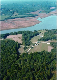
This is a traditional hide located at the wonderful Kings Landing Park. Along the shore of the Patuxent River, King's Landing Park has a history stretching back to Captain John Smith's exploration and earlier. Once an active farm and later a YMCA camp, the property was acquired by Maryland Department of Natural Resources and is now managed by Calvert County. Kayakers, canoeists, and fishermen enjoy King's Landing's relaxing access to the river, nearby creeks, and marshes.
Wayside exhibits, funded by the Chesapeake Bay Gateways Network, help visitors learn about the significance of the river and the abundant wildlife that depend on it. Hiking trails are open and beckon you and your dog for a jaunt.
There is no fee to use this park.
Hours are seasonal. January, February, March, November and December:
Weekends only, 8:30 a.m. - 5:00 p.m.
April, May, September and October
Monday - Friday, 8:30 a.m. - 4:30 p.m.
Weekends, 8:30 a.m. - 6:00 p.m.
Memorial Day Weekend through Labor Day
Open daily, 8:30 a.m. - 8:00 p.m.

Thanks to the Calvertcachers for helping with this hide and the Maryland Geocaching Society for assisting with this project!