Tiefbrunnen der Limes-Thermen EarthCache
Tiefbrunnen der Limes-Thermen
-
Difficulty:
-

-
Terrain:
-
Size:  (not chosen)
Please note Use of geocaching.com services is subject to the terms and conditions
in our disclaimer.
Baden-Wuerttemberg, Ostalbkreis, Aalen
Tiefbrunnen der
Limes-Thermen
|
Findet
das
Geologische Bohrprofil
des
Tiefbrunnen
der
Limes-Therme
Gestaltung:
R. Schlegelmilch
U. Sauerborn
W. Ernst Fichtenberg
Mitglieder der Geologie-Gruppe Aalen
|

|
Find
the
geological drill cores
of the
deep wells
of the
Limes-Therme
Design:
R. Schlegelmilch
U. Sauerborn
Ernst W. Spruce Mountain
Members of the geology group Aalen
|
Der Ariet
stand am Beginn einer verzweigten
Entfaltung der Ammonitentiere, nachdem vor
190 Mio Jahren die Schwarzjurazeit mit einer
ausgedehnten Meeresüberflutung angebrochen
war.
Verkieselte Hölzer sind die Relikte einer
Seen- und Flußlandschaft, die nach Abfluß des
Muschelkalkmeeres vorherrschte. Sie hinterlies
uns die vielfältigen Sedimente des Keupers.
Ausgedehnte Lagen von kristallinen Gips
durchziehen den unteren Keuper und geben
dem Wasser seinen hohen Sulfatgehalt.
Der Ceratit lebte im Binnenmeer Mitteleuropas
vor 220 Mio. Jahren. Im versteinerten Grundschlamm
dieses Meeres, dem heutigen Muschelkalk,
liegt das Quellniveau des Thermalwassers. |
The Ariet
was embarking on a branched flowering
of the ammonites animals after prior 190 million years
ago, the black jurassic period with an extended Sea
flood had begun.
Silicified woods are the remains of a lake and river
scenery, after drainage of Sea shell predominated.
They left us varied sediments of the Keuper.
Extensive traverse the lower layers of crystalline
gypsum Keuper and give the water its high sulphate
content.
The Ceratites lived in the inland sea 220 million years
ago in Central Europe. The fossilized slime this sea,
the current shell, is the source of thermal water
level.
|
|
Um diesen
Cache zu loggen,
macht ein Foto von euch und
eurem GPS-Gerät vor dem
Eingang beim Brunnen
mit den Säulen.
|
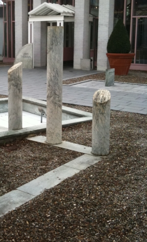 |
To log this cache,
takes a photo of you and
your GPS unit before
Entrance by the fountain
with the pillars. |
Sende die
Antworten zu folgenden Fragen an meine Emailadresse (siehe
Profil).
Beantwortet diese 3 Fragen die ihr beim Bohrprofil im Höhenmaßstab
1:140 recherchieren könnt:
1. Das Profil startet bei 0 m und geht bis zu xxx m.
2. Bei etwa 200 m im rosa Bereich findet ihr die xxxxxjura?
3. An der tiefsten Stelle im grauen Bereich ist der Muschelkalk
(Mittlere xxxxx).
Ihr dürft mit dem absenden der Antworten gleich loggen. Bei Problemen
melde ich mich!
|
Send the answers to these questions to my email address (see
profile).
Answer these 3 questions that you can search at the drill cores in
the height scale 1:140:
1. The profile starts at 0 m and goes up to xxx m.
2. At about 200 m in the pink area you will find the
xxxxxjura?
3. At the lowest point in the gray area is the Coquina Rock (Middle
xxxxx).
You can log when you send the answers. If there are any problems I
will contact you! |
Additional Hints
(Decrypt)
Ihr muesst keinen Eintritt bezahlen.
You have to pay no entrance fee.
Best time to search:
Mo - Do: 8.30 - 21.00 Uhr
Fr: 8.30 - 22.00 Uhr
Sa/So: 9.00 - 21.00 Uhr