|
 Laacher See: Basaltlavastrom Laacher See: Basaltlavastrom
Vor dem Ausbruch des Bimsvulkans und dem Einbruch des Laacher Kessels hat hier schon ein Tal bestanden, in das der Basaltlavastrom des Lorenzfelsens, dessen unter der mächtigen Bimsdecke verborgenen Ausbruchsstelle östlich von hier auf der Höhe liegen muß, hinabgeflossen ist. Das Gestein wird von den Gesteinskundlern als Leuzit-Nephelinit (alkalireiche Mineralien) bezeichnet. Die Schmelze ist nicht so gasreich gewesen wie bei anderen Lavaströmen im Laacher Vulkangebiet. Deshalb ist das Gestein hier dicht und zäh. (Quelle: Informationstafel)
Sowohl auf der Erdoberfläche fließende Lava als auch die aus der Bewegung heraus erstarrte Lava wird als Lavastrom bezeichnet.
Die Fragen
Bitte begebt euch an die oben genannte Koordinate. In der Nähe befindet sich eine Informationstafel. Lest euch die Tafel bitte sorgfältig durch und beantwortet folgende Fragen:
- Für welche Zwecke verwendeten die Mesnchen 3000 v.Chr. dieses Gestein?
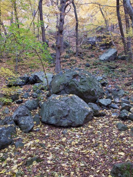
- Wie hoch ist der größte Stein in der Nähe der Informationstafel (geschätzt)?
Achtung! Es werden genau die Angaben gesucht, die auf der Tafel gemacht werden! Internet Lösungen können leider nicht akzeptiert werden.
Die Log-Bedingungen
- Bitte schickt uns eine Email mit den Antworten für die Fragen.
Sehr Wichtig! Bitte gebt im Betreff den EarthCache Namen und euren GC Namen mit an!
- Bitte macht freiwillig ein Bild von euch oder eurem GPS vor dem Basaltlavastrom und fügt es eurem Log-Eintrag hinzu.
Ihr könnt dann sofort loggen.
Falls etwas nicht richtig ist, werden wir uns bei euch melden!
Wir hoffen euch macht dieser EarthCache genau so viel Spaß wie uns! Wir danken euch für euren Besuch und freuen uns auf eure Emails!
Liebe Grüße Kate!
Waymarking
In Kombination mit dem Cache kann auch der Waymark WM7PJE gelogged werden.
 Laacher Lake: Basalt lava flow Laacher Lake: Basalt lava flow
This EarthCache leads you to the basalt lava flow of the "Lorenzfelsen" near the Laacher Lake. Before the eruption of the pumice vulcano and the collapse of the Laacher caldera a valley has existed into that the lava stream here already down-flowed. The material of the rocks is Leucite-Nepheline. The liquefied material was not so gassy than lava flows from other eruptions in this area. For this reason the rock is more compact and tough than other basaltic lava.
A lava flow is a moving outpouring of lava, which is created during a non-explosive effusive eruption. When it has stopped moving, lava solidifies to form igneous rock.
Questions
Please, head for coordinate mentioned above. Thereabouts is an information board. Read the board carefully by and answers the following questions:
- For which purpose humans used (among other things) this rocks 3000 BC ?
- Which height has the biggest rock near to the information board (estimated)?
Attention! The precise details are required, provided on the board! Unfortunately, solutions found in the internet cannot be accepted.
Log terms
- Please send us an Email with the answers to the questions above. Please wait for approval e-mail before you make your log. Important! Please add your GC Name to Email Subject!
- Please take a optional picture of you or your GPS in front of the lava flow and add it to your log.
Logs without approval Email will be deleted without comment.
We hope you will enjoy this EarthCache as much as we do. We thank you for your visit and are looking forward to your Emails!
Kind regards, Kate!
Waymarking
In combination with this cache you can log Waymark WM7PJE.
Statistik / Statistics
Historie / History
- 17.11.2009 Listing erstellt. / Listing created.
- 07.12.2009 Deutsche Beschreibung. Geocoin/Waymarking/Openaching hinzugefügt. / German description. Geocoin/Waymarking/ Openaching added.
- 08.12.2010 Geocoin entfernt. / Geocoin removed.
- 23.01.2011 Bild optional. / Picture optional.
- 17.07.2011 Log Bedingungen vereinfacht. / Log terms simplified.
- 13.05.2012 Opencaching entfernt. / Opencaching removed.
|