Earthcache features
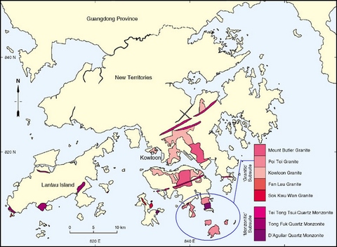
The granites here are Cretaceous intrusive rocks believed to have been emplaced less than 140 million years ago. Called the Po Toi Granite, they are part of a subcircular pluton centred on the south-eastern tip of Hong Kong Island. The pluton encompasses large outcrops of medium-grained granite exposed at Stanley Peninsula and D'Aguilar Peninsula, and granites exposed to the southeast on Sung Kong Island, Beaufort Island and Po Toi. The granite is also exposed on Castle Rock - a reef between Stanley and the Po Toi Islands. The earthcache location on Tai Tau Chau, near Shek O, is near the northern edge of the pluton.
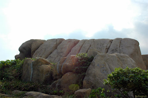
The pluton comprises megacrystic coarse-grained to equigranular fine-grained biotite granite. On Tai Tau Chau, fine-grained granite has intruded fine-to-medium-grained granite. Nearby, on Shek O Headland, similar infiltration of the fine-to-medium-grained granite has taken place.
The granitic coastal erosion landforms of the Shek O area took shape due to prolonged exposure to northeast and southeast monsoon winds, the cracked texture of granite and the fault lines in rocks generated by crust movements. Tai Tau Chau and Ng Fan Chau used to be parts of the mainland, but are now islands with the sea having eroded away the land along major lines of weakness of the rocks. One can see today numerous sea caves and clefts of different sizes distributed along the coast of these two islands.

Where the rock is hard, constant wave attack at the base leaves a steep, near-vertical cliff. Wave-driven erosion is concentrated at the foot of the cliff. The waves cut a notch into the cliff foot. The cliff above the notch eventually collapses, leaving the cliff further back. As this process is repeated, a wave-cut platform is left at the cliff foot, indicating retreat.
Wave attack picks out cracks, joints and weaknesses in the cliff. A sea cave is formed at the base of the cliff. Hydraulic action then helps enlarging the cave. When the wave attacks the cave the air trapped inside is compressed and loosens the rock. When the wave retreats the pressure suddenly releases and the overhanging rock fragments will fall down and accumulate to form a boulder beach. As hydraulic action continues, the sea cave enlarges and when there is a vertical line of weakness, a tunnel is formed to the surface above and forms a blow hole. In time when the roof of the cave collapses, a steep-sided narrow inlet or geo is created.
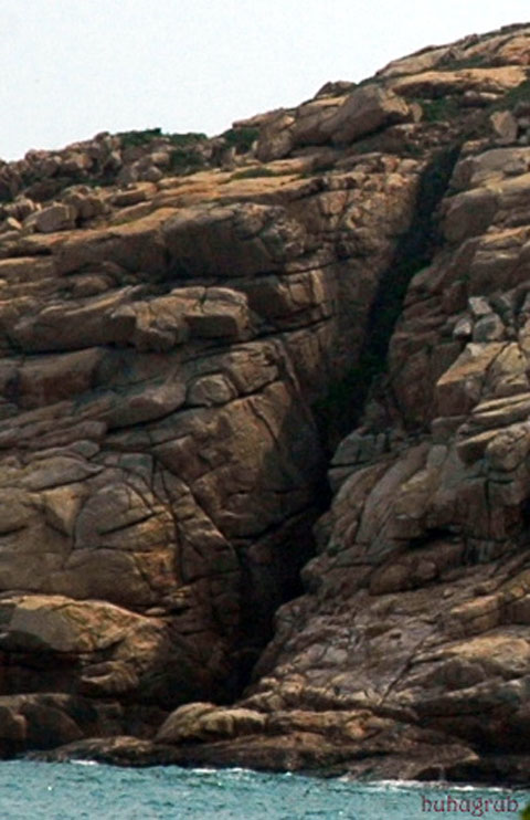
Geos are linear clefts in a sea cliff that reflect marine erosion along lines of weakness. Where faults, joints and other fractures intersect the cliff face then linear zones of fractured rocks are available for wave erosion. Long, narrow slots develop in response to selective marine erosion between adjacent rock buttresses. As mentioned above, geos can also form through roof collapse of narrow sea caves. Many geos have a boulder beach at their head, generally with large amounts of flotsam.

The restricted width of many geos is a reflection of the narrowness of the line of geological weakness that is being exploited. The processes of landward extension are little understood. Where the geo ends in a rock wall then cavitation and hydraulic action must be dominant. Geos with bay head beaches have the possibility of abrasion, but erosion by abrasion will generally be slow as the boulders are only mobilised during major storms. Where fracturing or weathering has reduced the rock into small blocks or even grit then the sluicing effects of spray will remove this debris and may undermine larger blocks.
How to get to the earthcache location
You can take a bus to Shek O. Walk via Shek O Village Road and Shek O Headland Road to the steps leading down to the tombolo bar linking Shek O Headland to Tai Tau Chau. There is a footbridge to Tai Tau Chau, so the earthcache should be accessible even during high tides.

On Tai Tau Chau, you can see many examples of rocks affected by denudation.

At GZ, you will be standing at the head of a geo. At various points on Tai Tau Chau, you can also look across to Ng Fan Chau to the south to see more geos and their associated distinctive lines of weakness across the island.
Take care as you will be standing quite close to the cliff. Do not cross the safety barriers.
Note: There used to be a 5/5 cache on Ng Fan Chau (GC1DRP4), which has been archived.
Earthcache logging requirements
- Estimate the height of the geo at GZ on Tai Tau Chau.
- Estimate the width of the geo at GZ on Tai Tau Chau.
- How many distinctive major lines of weakness in Ng Fan Chau can you identify?
- Post a photo with your GPSr with a background of a rock that is affected by denudation on Tai Tau Chau.
Email us your answers to Q1 to Q3 and post your photo with your log. Wait for us to acknowledge your answers before posting, and do not post the answers with your log.