 |
Die Drachenschlucht
bei Eisenach
|
|
|
 |
The Dragon Canyon
near Eisenach
|
|
|
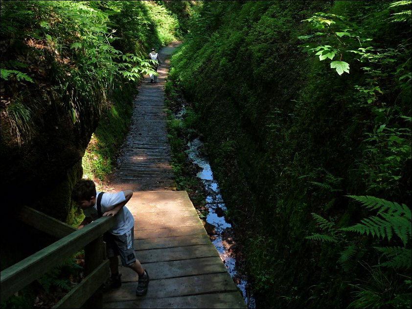
| Die Drachenschlucht befindet sich im Süden von Eisenach, zwischen dem südlichen Stadtrand (Hotel Sophienaue) und dem Forstort Hohe Sonne am Rennsteig. Hier befindet sich das Annatal, der südliche Abschluss des Marientales. Die Drachenschlucht bildet mit der östlich benachbarten Landgrafenschlucht und dem aus dem Johannistal aufsteigendem Ludwigsklamm vielbesuchte Wanderziele, vor allem in den heißen Sommermonaten. Der südliche Zugang befindet sich an der Hohen Sonne, der nördliche Zugang liegt an der Auffahrt zum Waldhaus Sängerwiese. An beiden Hauptzugängen bestehen Parkplätze für Wanderer.
Seit 1961 ist das Waldgebiet zwischen Hohe Sonne und Wartburg als Naturschutzgebiet ausgewiesen, 1977 wurden die Drachenschlucht, Landgrafenschlucht und einige Grotten in der Nähe zusätzlich als geologische Naturdenkmale unter Schutz gestellt. Die Errosionsformen gelten als eine der größten geologischen und morphologischen Sehenswürdigkeiten der Region.
Das Gestein der Schlucht besteht aus Rotliegend, ine Gesteinseinheit bzw. eine Einheit der Lithostratigraphie im hierarchischen Rang einer Gruppe und der untere Abschnitt der mittel- und westeuropäischen Dyas. Die Dyas ("das Zweigeteilte", nach der in Mitteleuropa ausgeprägten Zweiteilung in Rotliegend und Zechstein) war eine alternative Bezeichnung des Perm-Systems, die sich international nicht durchsetzen konnte. In der heutigen wissenschaftlichen Auffassung ist Rotliegend kein Zeitintervall mehr, sondern lediglich eine rein durch lithologische Merkmale definierte Gesteinseinheit.
Weiterführende Informationen gibt es bei Wikipedia.
|
|
The Drachenschlucht (dragon canyon) is located south of the city of Eisenach, between the southern outskirts (Hotel Sophienaue) and Hohe Sonne at the Rennsteig ridge walk. Located here is the Annatal (Anna valley), the southern end of the Mariental (Marien valley). Together with the adjacent Landgrafenschlucht (Landgrafen canyon) and the Ludwigsklamm (Ludwig's gorge) - rising up from the Johannestal - the Drachenschlucht is an often visited destination of hikers, especially during the hot sommer month. The southern entrance is near the Hohe Sonne, the northern entrance at the driveway to the Waldhaus Sängerwiese. At both entrances you will find parking areas for your car.
Since 1961 the woodland between Hohe Sonne and Warburg castle is a protected nature reserve, 1977 the Drachenschlucht, the Landgrafenschlucht and some nearby grottos were protected as geological natural monuments. The found erosions are some of the most interesting geological and morphological landmarks of the area.
The rocks in the canyon consist of Rotliegend (German: the underlying red), a lithostratigraphic unit (a sequence of rock strata) of Cisuralian (early Permian) age that is found in the subsurface of large areas in western and central Europe. The Rotliegend mainly consists of sandstone layers. It is usually covered by the Zechstein and lies on top of regionally different formations of late Carboniferous age. The name Rotliegend has in the past not only been used to address the rock strata themselves, but also the time span in which they were formed (in which case the Rotliegend was considered a series or subsystem of the Permian). This time span corresponds roughly with the length of the Cisuralian epoch.
You can get additional information at Wikipedia.
|
|
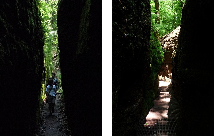
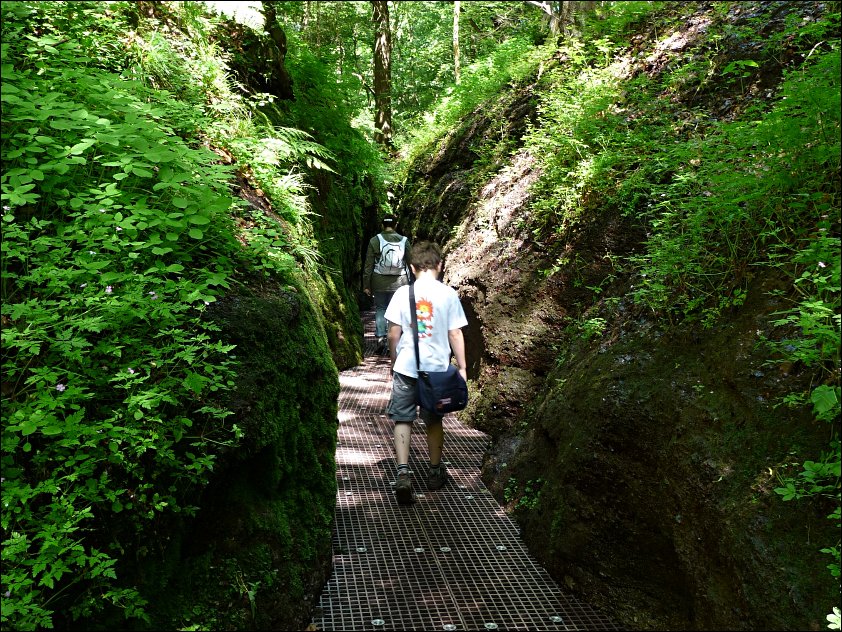
| Um die Schlucht sicher und begehbar zu machen, mussten mühsam Wege und Stufen in den Fels gehauen werden, über viele Meter wurde der Weg mit Holzbohlen und Stegen über den Quellbach fortgeführt. Leider zerstören die Naturgewalten - in der Schlucht entstehende Eismassen im Winter und die bei Unwettern auftretenden Fluten diese Wegpartien, so dass immer neue Ersatzbauten nötig sind. In der Saison 2009 werden durch die Forstleute als Betreiber nun erstmals Gitterroste aus robustem Kunststoff eingebaut und erprobt.
Die etwa 3 Kilometer lange, an der engsten Stelle nur 68 Zentimeter breite Schlucht gliedert sich in die folgenden Abschnitte:
| 0 m |
Wegpunkt "PARK2", Parkplatz am Königstein, Auffahrt zum Waldhaus Sängerwiese (261,3 m.ü.NN) |
| 160 m |
Am Ochsenteich, geschnitztes Drachenportal und Informationstafeln |
| 720 m |
10 m hohe Felswand mit Monogramm A für Annatal; Ausstieg über 1. Seitenschlucht (rechts) zum Knöpfelsbach und Waldhaus Sängerwiese; Schutzhütte am Beginn/Ende der nun folgenden Passage |
| 725 m |
198 m lange Passage mit zahlreichen Engstellen, Strudelnischen, Erosionskesseln und Rieselwasserfällen |
| 1030 m |
Ausstieg über 2. Seitenschlucht (rechts) zum Töpfchensborn |
| 1720 m |
Ausstieg über 3. Seitenschlucht (rechts) in die Veilchenberge |
| 1915 m |
Kürzere Passage mit 2. Felsenge |
| 2475 m |
Kürzere Passage mit 3. Felsenge |
| 2790 m |
Marienbachquelle (395 m.ü.NN) |
| 3015 m |
Wegpunkt "PARK1", südlicher Einstieg über Treppenanlage an der Hohen Sonne; Informationstafeln (430 m.ü.NN) |
|
|
In order to make the canyon more safe and easier to hike trough, paths and steps were hit in the rocks, here and there the catwalk leads directly over the stream on timber planks. Regrettably the forces of nature destroy this parts of the path during winter and after heavy rains, so reconstruction is necessary from time to time. In the 2009 season plastic gratings were installed and tested by the forest authorities.
The approximately 3 km (1.8 mls) long and at the most narrow location only 68 cm (27 inches) wide canyon from north to south:
| 0 m |
Waypoint "PARK2", parking area at Königstein, driveway to Waldhaus Sängerwiese (261,3 m above sea level) |
| 160 m |
Near Ochsenteich, carved dragon-portal and information boards |
| 720 m |
10 m high rock face with large carved letter A for Annatal; exit over first side canyon (right) to Knöpfelsbach and Waldhaus Sängerwiese; bothy at begin/end of the following section |
| 725 m |
198 m long section with numerous narrow places, swirl niches, erosion calderas and small waterfalls. |
| 1030 m |
Exit over second side canyon (right) to Töpfchensborn |
| 1720 m |
Exit over second side canyon (right) to the Veilchenberge (Veilchen mountains) |
| 1915 m |
Short section with second rock bottleneck |
| 2475 m |
Short section with third rock bottleneck |
| 2790 m |
Marienbach spring (395 m above sea level) |
| 3015 m |
Waypoint "PARK1", southern entry of stairs at the Hohe Sonne; information boards (430 m above sea level) |
|
|
Um den Earthcache zu loggen, beantworte bitte die folgenden Fragen:
- Welche Gesteinsart liegt im Hangprofil des Annatals zwischen dem Aschburg-Konglomerat und dem Wartburg-Konglomerat?
- Vor wievielen Jahr bildete sich der sogenannte Rotliegende, ein widerstandsfähiger Konglomeratfels?
- Suche den unten abgebildeten Wegweiser zu den Rundwanderwegen, welche drei Wege können von hier aus begangen werden?
- Der Wegweiser zu den Knöpfelsteichen führt noch zu einem anderen Ziel. Wohin geht es noch?
Sende die Antworten über mein GC-Profil.
Die engste Stelle der Drachenschlucht ist nur 68 cm breit, suche diese Stelle oder eine ähnlich enge Stelle und mache - nur wenn Du möchtest - ein Foto von Dir oder Deinem GPS und lade es nach Logfreigabe bei Deinem Log hoch. Das Foto ist absolut freiwillig, ich würde mich aber darüber freuen! Nach dem Senden der Antworten einfach loggen, ich melde mich falls etwas nicht passt!
|
|
To claim this earthcache you will need to answer the following questions:
- Which type of rock in the profile of the Anna valley is in between the Aschburg-conglomerate and the Wartburg-conglomerate?
- How long ago was the so called Rotliegende formed, a resistant conglomerate rock?
- Search for the shown fingerpost (left) to the Rundwanderwege (circular walking route), which 3 routes can be hiked from here?
- The fingerpost (right) to the Knöpfelsteichen points to another destination. Where does the path go to?
Send the answers via my GC-profile.
The most narrow constriction in the dragon canyon is just 68 cm wide, search for this location and - just if you like - take a picture of yourself or your GPS device and add it to your log after your got the my reply, that your answers are correct. The photo is not mandatory, but i would be happy to see you at this spot! Just log the cache, don't wait for my answer! I'll contract you, if your answers are not OK.
|

|
| Wandervorschlag:
Wenn man genügend Zeit hat, kann man die Tour durch die Drachenschlucht mit einem Ausflug auf die Wartburg kombinieren. Dazu parkt man an der Hohen Sonne - hier gibt es genügend kostenlose Parkplätze - und läuft dann durch die Drachenschlucht. Am unteren Ende der Drachenschlucht führt ein Wanderweg hinauf zum Waldhaus Sängerwiese (siehe Wegpunkt "REST"), wo man einkehren kann, das Essen dort ist sehr empfehlenswert, vor allem die Bratkartoffeln sind sehr lecker! Vom Waldhaus ist der Weg zur Wartburg gut ausgeschildert. Von der Wartburg aus kann man mit dem Bus zurück zur Hohen Sonne fahren (Nur am Wochenende, Abfahrt am Parkplatz) oder weiter ins Zentrum von Eisenach wandern, von wo auch Busse zur Hohen Sonne fahren (Linie 11 und 31).
Informationen, auch über eventuelle Sperrungen der Schlucht, erteilt die Eisenach-Wartburgregion Touristik GmbH unter der Telefonnummer 03691-79230 (Mo-Fr 8.00 - 17.00 Uhr).
|
|
Hiking recommendation:
If you have enough time, you can combine the hike through the dragon canyon with a trip to the Wartburg castle. Park your car at the southern entrance Hohe Sonne - there is plenty of free parking space for your car - and hike through the dragon canyon. At the lower end of the canyon take the path to Waldhaus Sängerwiese (see waypoint "REST"), where you can stop for a bite to eat. The food is great, especially the baked potatoes are delicious. From the Waldhaus the path to the castle is signposted, you can't miss is. From the castle you can take a bus back to your car or just walk down to Eisenach and take either bus 11 or 31 back to Hohe Sonne.
You can get additional informations at the tourist office of the Eisenach-Wartburg region on the telephone, call 03691-79230 (Mo-Fr 8.00 - 17.00 o'clock).
|
|
|