Teufelskirche
(Devil’s Church)
Die
Rhätschlucht Teufelskirche bei Grünsberg ist seit fast 100 Jahren
als Naturdenkmal anerkannt. Sie ist ein ausgewiesenes Geotop des
Bayerischen Landesamts für Umwelt (www.lfu.bayern.de).
Die Schlucht ist etwa 600m lang. Bei Schnee und Eis kann die
Terrain-Wertung um einen Punkt steigen.
Das Gebiet bei Altdorf gehört zum Vorland der Mittelfränkischen
Alb. Die Landschaft ist geprägt durch das Schwarzachtal, das sich
südwestlich von Altdorf als steile Schlucht in den Rhätsandstein
schneidet.
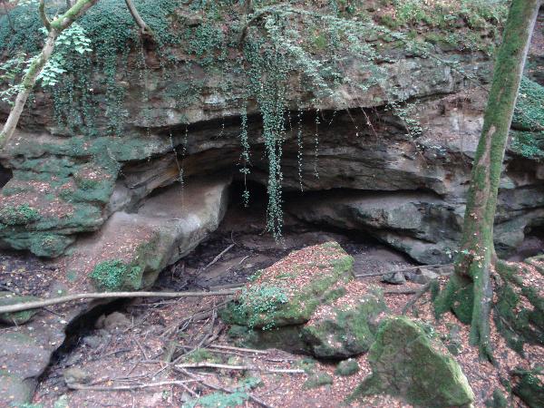
Die
Schlucht
Freilegungen
von Gesteinen und Böden, die durch natürliche Prozesse entstanden
sind, werden als natürliche Aufschlüsse
bezeichnet. Der Bach, der durch die Schlucht
„Teufelskirche“ fließt, ist ein Seitenbach der
Schwarzach. Im Lauf der Jahrtausende hat er sich in die Schichten
des Rhät-Lias-Sandsteins und des Oberen Feuerlettens eingegraben.
Solche Aufschlüsse sind selten.
Rhätsandstein
Vor ca. 200
Mio. Jahren, in der Übergangszeit zwischen Trias (Oberer Keuper =
Rhät) und Jura (Lias), gab es in Mittelfranken ein flaches
Binnenmeer im Nordwesten und Festland im Südosten. Es wurden
feinkörnige und sandige Sedimente abgelagert, die sich später zu
Ton- und Sandstein verfestigten. Da man nicht unterscheiden kann,
welche der Gesteine aus Rhät und welche aus Lias stammen, nennt man
sie Rhäto-Lias-Übergangsschichten.
An den Oberhängen und am Ende der Schlucht erkennt man den
braun-grauen Rhätsandstein. Im Unterlauf kann man den aus Tonen
entstanden Oberen Feuerletten sehen.
Wasserfall
Am Ende der
Schlucht ist ein Wasserfall. Dieser entstand dort, wo grobkörnige,
harte Arietensandsteine mit weicheren Rhätolias-Sandsteinen in
Berührung kamen.
Braunkohle
Da der
Rhätsandstein durch Verwitterung mürbe wird und leicht zerfällt,
wurden kleine Kohlefläze freigelegt, die aus Fossilen
Pflanzenresten bestehen (Rhätkohle). Am Fuß der Felskaskade
befinden sich Stollen, die von Menschen auf der Suche nach
Braunkohle und Silber aus Schwefelkies angelegt wurden. Bereits in
den Jahren 1525, 1600 und 1720 wurde dort versucht, Bergbau zu
betreiben.
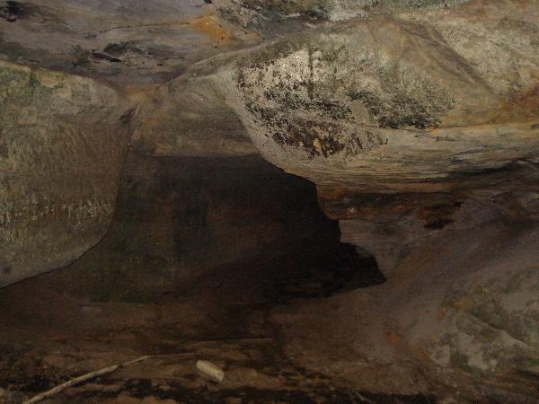
Stollen
Im
Eingangsbereich des Hauptstollens ist ein altes Abbauflöz der
Braunkohle zu erkennen.
Fragen:
- Begib dich zur Startkoordinate. Dort findest du eine Tafel.
Seit wann genau ist die „Teufelskirche“ als
Naturdenkmal ausgewiesen?
- Nun gehe durch die Schlucht zu N 49°22.606‘ E
011°20.001‘. Begib dich zum Hauptstollen und suche das
Abbauflöz im Eingangsbereich. Wieviel cm misst es im Durchschnitt
(Höhe und Breite)?
- Mache ein Foto von dir mit deinem GPS an der Zielkoordinate vor
den Stollen.
Schicke eine E-Mail mit den Antworten an unseren GC-Account, die
Logfreigabe wird so schnell wie möglich erteilt!
Viel Spaß beim Wandern durch die Schlucht! Dort könnt ihr auch noch
GCPC7A machen.
English
description:
The Rhaet
canyon „Teufelskirche“ (Devil’s Church) next to
Grünsberg has been a nature monument for almost 100 years. It is an
official geotope according to the Bavarian Environment Office
(www.lfu.bayern.de).
The canyon is about 600m long. If there is snow and ice, the
declaration of terrain can go up one point.
The Altdorf area belongs to the foreland of the Middle Franconian
alp. The nature is given distinction by the Schwarzach valley,
which cuts into the Rhaet sandstone as a steep canyon south-west of
Altdorf.
The
canyon
Exposures of
stone and grounds, originated through natural processes, are called
natural outcrops. The brook flowing through the
“Teufelskirche” canyon is a tributary brook of the
Schwarzach. In the course of many centuries it has carved itself
into the layers of the Rhaet-Lias sandstone and the upper
potter’s earth. You can rarely find such outcrops.
Rhaet
sandstone
About 200
million years ago, in the time between Trias (upper keuper marl =
Rhaet) and Jurassic (lias) in Middle Franconia there were narrow
continental waters in the north-west and mainland in the
south-east. Fine grained and sandy sediments were deposited, which
later hardened to mudstone and sandstone. Because you cannot see
which stones origin from Rhaet and which from lias, they are called
Rhaet-lias crossover layers.
On the upper hillsides and at the end of the canyon you can see the
brown-grey Rhaet sandstone. In the underflow you can see the upper
potter’s earth, which originates from mudstone.
Waterfall
At the end of
the canyon there is a waterfall. It originated where coarse grained
hard sandstone had contact with softer Rhaet-lias
sandstone.
Browncoal
Because Rhaet
sandstone is getting brittle through weathering and breaks easily,
little coal louts, which are made up of fossile plant remnants,
were laid open (Rhaet coal). At the bottom of the cliff cascade
there are tunnels made from pyrites, built by people looking for
browncoal and silver. As early as 1525, 1600 and 170 people tried
mining there.
Tunnel
At the
beginning of the main tunnel you can see an old mining bed for
browncoal.
Questions:
- Go to the start coordinates. You will find a table there.
For how long exactly has the “Teufelskirche” been an
official national monument?
- Now go to N 49°22.600‘ E 011°20.000‘ through the
canyon. Go to the main tunnel and look for the mining bed in the
entrance area. How many cm is it on average (height and
breadth)?
- Take a photo of yourself with your GPS at the target
coordinates in front of the tunnel.
Send an email with the answers to our GC-account. The log approval
will be issued as soon as possible!
Have fun hiking through the canyon. You can also do GCPC7A
there.