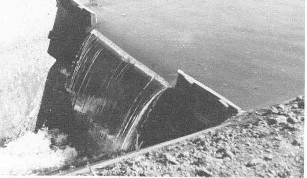
Weir Dams
A weir dam is a small overflow-type dam commonly used to raise the level of a river or stream. Weir dams have historically been used to create mill ponds but have also been used to create fishing ponds or to slow the rate of erosion. Water flows over the top of a weir. Since the weir is the portion where water is overflowing, a long weir allows a lot more water with a small increase in overflow depth. This is done in order to minimize fluctuation in the depth of the river upstream with changes in the flow rate of the river. Weirs also give hydrologists and engineers a simple method of measuring the rate of flow over the weir. There are different types of weirs. It may be a simple metal plate with a V notch cut into it or it may be a concrete and steel structure across the bed of a river.
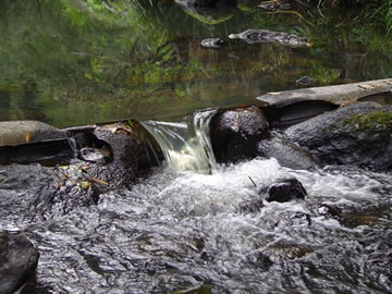
Sharp Crested Weir
A sharp-crested weir allows the water to fall cleanly away from the weir. Sharp crested weirs are typically thin metal plates
Broad Crested Weir
Broad crested weirs are large structures that are generally constructed from reinforced concrete and which usually span the full width of the river. 
Crump Weir
A Crump weir is a fixed weir dam with water flowing over it and usually it has a trapezoidal shape while being made out of concrete.If the down-stream level below the weir crest is about the same as the up-stream it can be known as an underwater weir

Proportional Weir or "V" notch weir
A specially shaped weir in which the flow through the weir is directly proportional to the head.
Combination Weir
For accurate flow measurement over a wider range of flow rates, a combination weir combines 2 or more types of weirs. Below a V-Notch weir with a crump weir

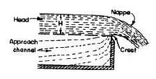
There are several terms associated with weir dams.
Nappe the flow or discharge after the crest.
Head the level above the crest
Crest the width of the top of the weir
Approach the level of the river below crest also know as the datum.
1. (optional)Take a photo of you and your GPSr at the posted coords with the small island with palm trees on it created by the dam and post it to this page when you log it.
2. How many weir dams are in a row here and what type are they?
3. Is there water flowing over each dam? What can you determine from the water table from that? when submitting answers to through my profile link above label the dams from starting from the first one on the North side of Della drive to the the just north of Somerset Shores Court. In ascending order.
4. What is the elevation change from first to last dam in feet?
5. Do the dams play a part in preventing erosion or are they just used to create decrotive ponds?
6. Is the first pond feed by a stream or a spring?
Many of Florida's lakes have springs in them, small sandy rareas that feed considerably smaller flow of water into the lake. The water table is the level of the ground water in relation to the surface.The form of a water table may change and vary due to seasonal changes, topography and structural geology. In undeveloped regions, or areas with high amounts of precipitation, the water table roughly follows the contour of the overlying land surface, and rises and falls with increases or decreases in infiltration. Springs and oases occur when the water table reaches the surface. Springs commonly form on hillsides, where the Earth's slanting surface may "intersect" with the water table. Other, unseen springs are found under rivers and lakes, and account for the base-flow water levels in water bodies.Water-bearing sedimentary rocks in Florida can generally be divided into two types: siliciclastics (sands, silts, clays) or carbonates (limestone and dolostone). All of these rocks, no matter how "hard" or solid they appear, contain some voids or pores, which may contain water. Two properties that are common to all these rocks, and which control the movement of their ground water, are porosity and permeability. Porosity and permeability are intimately related. Porosity refers to the pores themselves, while permeability is a measure of a rock's ability to allow fluids to move through its pores. For a rock to be permeable, its pores must be interconnected so that water can move freely. Aquifers are subsurface zones of rocks that yield water in sufficient quantities to be economically useful for society's activities. Aquifers are classified as either unconfined, semi-confined, or confined, depending on the physical conditions under which the water is contained in an aquifer's rocks. Florida has all three types of aquifers in various combinations throughout the state. The Floridan aquifer system (FAS), which underlies all of Florida, is the main source of potable ground water for much of the state. However, in the extreme western panhandle and in south Florida the FAS is either too deep or contains water of poor quality.
Sources:
http://www.dep.state.fl.us/geology/default.htm
http://en.wikipedia.org/wiki/Water_table