Naturdenkmal "Geologische Wand
Elmenthal"
Natural Monument "Geological Wall
Elmenthal"
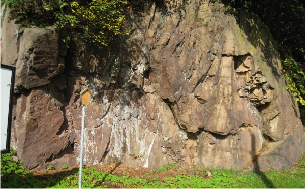
 A specific geological feature of the
Thuringian Forest is the occurrence of "mixed" or "combined"
magmatic dykes in the area of Trusetal. Hot and viscous rock
melts of different composition penetrated the earth's upper
crust, cooled and crystallized. At this Natural Monument, such
a dyke crops out in a cross-cutting wall.
A specific geological feature of the
Thuringian Forest is the occurrence of "mixed" or "combined"
magmatic dykes in the area of Trusetal. Hot and viscous rock
melts of different composition penetrated the earth's upper
crust, cooled and crystallized. At this Natural Monument, such
a dyke crops out in a cross-cutting wall.
 Eine geologische
Besonderheit im Thüringer Wald in der Umgebung von Trusetal
sind die sogenannten zusammengesetzten oder gemischten
magmatischen Gänge. Sie entstehen, wenn heißes, zähfliessendes
Magma aus unterschiedlichen Quellen in Spalten der Erdkruste
eingringen, dort auskühlen und kristallisieren. Hier am
Naturdenkmal kann man einen wunderschönen Querschnitt durch so
einen zusammengesetzten Gang ansehen.
Eine geologische
Besonderheit im Thüringer Wald in der Umgebung von Trusetal
sind die sogenannten zusammengesetzten oder gemischten
magmatischen Gänge. Sie entstehen, wenn heißes, zähfliessendes
Magma aus unterschiedlichen Quellen in Spalten der Erdkruste
eingringen, dort auskühlen und kristallisieren. Hier am
Naturdenkmal kann man einen wunderschönen Querschnitt durch so
einen zusammengesetzten Gang ansehen.
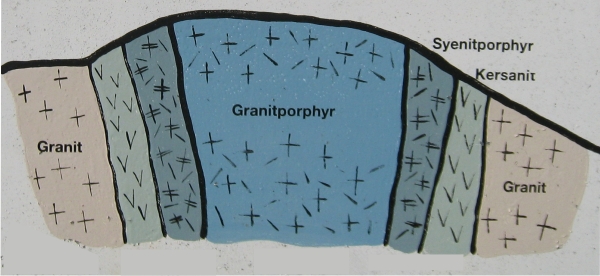
You can identify three phases
of penetration, which differs in chemistry an rock
type:
(1) Kersantit intrusion
(biotite-hornblende-augite) in Granite (feldspar, quartz,
mica)
(2) Syenit intrusion (feldspar,
quartz) in Kersantit
(3) Granitporphyr intrusion
(feldspar, quartz, biotite) in Syenit
Man kann hier drei Phasen
des Eindringens von unterschiedlichem Ganggestein
beobachten:
(1) Kersantit
(Biotit, Hornblende, Augit) dringt in Granit (Feldspat, Quarz,
GLimmer) ein
(2) Syenit
(Feldspat, Quarz) dringt in Kersantit ein
(3) Ein
Granitporphyr (Feldspat, Quarz, Glimmer) dringt in den Syenit
ein
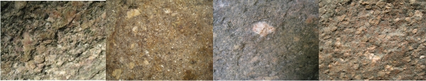
If you take a close look at
the rocks in the outcrop, you can easily distinguish the
different rocks by their texture.
Wenn man sich die Gesteine
im Aufschluss genauer ansieht, kann man sehr leicht die
Unterschiede erkennen.
Requirements for
logging
Before logging this EarthCache you must answer
the following study questions:
a) How
many million years ago did the dykes start to intrude into the
Granite? (=ABC million years)
b) What
is the width of the Granitporphyr intrusion at the base
of the
outcrop?
(=D metres)
c) What
is the width of the Syenitporphyr? (=E,F metres)
Send an e-mail to
ABCDEF@sosala.de with your team name as
subject. You will get the logging permission by
auto-response.
You must
include to your log a picture of you and/or your GPSr with
the Natural Monument in the background.
Do not post any answers in the log
or post pictures showing the information table. Logs
without clearance or without pictures will be
deleted.
Logbedingungen
Bevor
du diesen EarthCache loggen kannst, musst du folgende Fragen
beantworten:
a) Vor wieviel
Millionen Jahren begannen die Gänge in den Granit zu intrudieren?
(=ABC Millionen Jahre)
b) Wie breit ist die
Granitporphyr-Intrusion an der Unterkante des Aufschlusses? (=D
Meter)
c) Wie breit ist der
Syenitporphyr? (=E,F Meter)
Schicke eine e-mail an
ABCDEF@sosala.de mit deinem Spielernamen
als Betreff. Du erhälst die Logerlaubnis
automatisch.
Du musst
deinem Log ein Bild anhängen, dass dich und/oder dein GPSr
mit dem Naturdenkmal im Hintergrund zeigt. Schreibe bitte keine
Antworten im Log oder zeige Bilder, auf denen die Info-Tafel zu
sehen ist. Logs ohne Logerlaubnis oder ohne Bilder werden
gelöscht!