
Brayford Pool and its Sedimentary Construction.
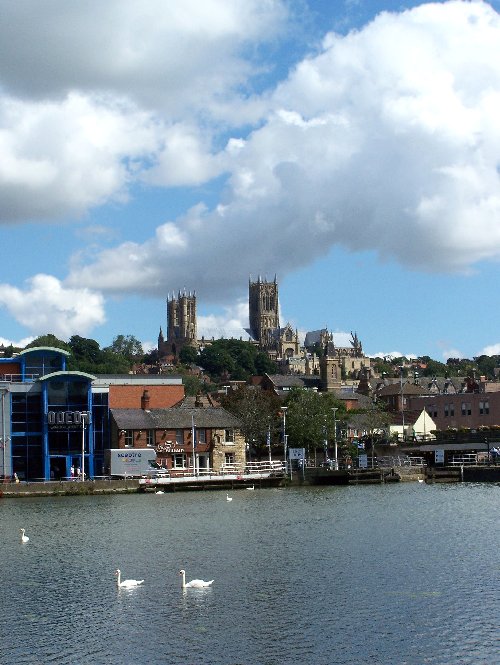
The Brayford Pool lies on the river Witham at the point where the river, flowing northwards towards the southwest corner of the ancient walled city, turns eastward through the gap in The Lincolnshire Edge. The Edge is a west facing scarp slope formed by the resistant Middle Jurassic rocks, the principal member of which is the Lincolnshire (oolitic) Limestone.
 The Edge is a continuation of the Cotswolds and continues on into the North Yorkshire Moors and is more loosely known as the Jurassic Way. On one slope the cliff edge village of Washingborough. On the other slope lays the ancient city of Lincoln, dominated by the Norman Castle and Cathedral. Brayford Pool also forms the junction between the river and the Foss Dyke, the former Roman canal linking the Witham with the river Trent to the west
Lincoln City was sited not far from the head of an estuary. A classic estuarine creek system is indicated on air photographs extending up to a point approximately 8km east of Lincoln. Upstream of this, channel features are obscured by deposits of peat 1-2m or more in thickness, often separated by channels containing sand rather than the coarse silt and fine sand characteristic of estuarine sediments.
 The earliest sedimentary deposits examined so far in the city, which appear to be Fen Clays at Brayford Wharf East, are probably of Bronze or Iron Age date. Unfortunately, the lack of diatoms and molluscs from these sediments made it difficult to establish whether they were deposited in brackish or fresh-water conditions.
These data imply that, during the late prehistoric period, still-water deposits accumulated in what was to become the Brayford Pool. They were approximately at their contemporary sea-level, and may well have been connected directly with it. The abundance of Phragmites and other rushes indicates an environment of pools choked with rushes.
By the Roman period the water level at Brayford Wharf East appears to have risen 1-2m above the high water mark as indicated from sites on the coast. Molluscan examination and particle-size analysis showed that sediments within the Roman channel were dirty, poorly sorted, included some small lenses of silt and peat, and contained bone, artefacts, and other settlement debris.
They are likely to have been deposited in a turbid body of fresh water of variable flow velocity. This increase in velocity, along with the rise in water level, suggesting that man was influencing the flow conditions.
Dredging and the addition of lock and sluice gates, as well as clearance of woodland within the Witham basin upstream may have increased run-off, thus raising the water level. It is therefore evident that Lincoln occupied a primarily riverine, as opposed to an estuarine, site.
Between the 4th and 9th centuries there was stagnation in flow conditions resulting in the accumulation of thick layers of peat. This might have been caused by extensive silting and lack of channel maintenance downstream. Water levels at this time remained at approximately the same level as during the late Roman period, but possibly fell in the 10th or 11th century.
 The clearance of the river may have coincided with the extensive commercial development of the lower town from the late 9th or early 10th century. The evidence from the Brayford Pool sites at least suggests that the waterways at or near Lincoln were cleared during the period c 875-c 975.
The most dramatic event during this period at the Brayford Wharf East site was the rapid migration of the waterfront as a result of the construction of hurdle structures in the shallows. These resulted in variable flow conditions, with sands being deposited in the fast flow on the channel side of hurdles, and peat’s in weedy or rush-choked ponds on the bank side, suggesting that the hurdles were set near the main channel. It is possible, however, that the peat accumulation was at least partly man-induced.
By the time the present waterfront was fixed during the 19th or 20th century, the water's edge had migrated some 45m west in approximately 1000 years.
 To claim this cache you must take a minimum of 2 photographs (in different locations) one of which must include yourself and your gps. Both photos must have a view of Brayford Pool in the background. Please post these on the page with your claim. (Photo request protected under grandfather rights, however if your shy, send your photos direct with your message rather than posting to the page. It is just to verify you have been to the location.
In addition please answer the following 3 questions.
The Jurassic is a geologic period and system that extends from about 199.6± 0.6 Ma (million years ago) to 145.5± 4 Ma, that is, from the end of the Triassic to the beginning of the what period?
Oolite (egg stone) is a sedimentary rock formed from what?
Estimate is the length of The Brayford Pool from the eastern quay by the road and waterfront flats to University Bridge in the west.
You ,may claim your find immediately. Please upload your photos at the same time. Then email your answers via my profile above. If your answers are incorrect, I will contact you. If you receive no reply within 24hrs, assume all is ok and your claim is valid. However. If you claim and no answers are received within 24 hours, your claim will auto destruct, the log will be assimilated into the depths of the Brayford Pool never to be seen again.I watch out for cheats as I have nothing better to do with my life.
Under no circumstances should you post the answers in your log or post photographs of the answer. You must physically visit this cache in order to log it, (I regret that I will have to delete logs that do not meet these requirements). When you email the answer then please remember to release your email address to enable us to reply.

The Imp is a Platinum Earthcache Master.