Backofenfelsen (oven rocks) EarthCache
Backofenfelsen (oven rocks)
-
Difficulty:
-

-
Terrain:
-

Size:  (not chosen)
Please note Use of geocaching.com services is subject to the terms and conditions
in our disclaimer.

- Deutsch -
Das Döhlener Becken ist eine Landschaftseinheit in Sachsen südwestlich von Dresden. Es erstreckt sich mit einer Länge von 22 km und einer Breite von 6 km über den Landkreis Sächsische Schweiz-Osterzgebirge.
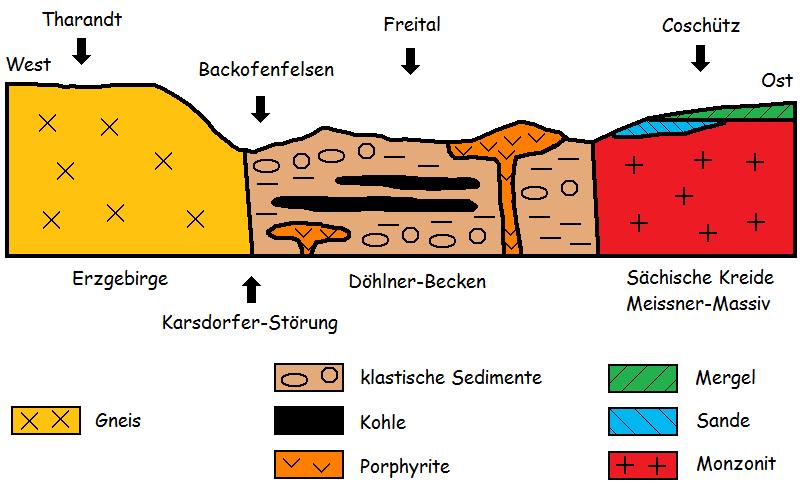
Schon 500m weiter Richtung Tharandt ist die Karsdorfer Störung, sie ist eine geologische Bruchlinie / Abgrenzung im Bereich des östlichen Erzgebirges und des Elbsandsteingebirges. In Höhe Freital-Hainsberg befindet sich eine Engstelle des Döhlener Beckens mit nur etwa 270 Metern Entfernung zwischen dem Backofenfelsen und dem auf einem Felsen stehenden Kreuz (Denkmal 1. Weltkrieg) am Vorholz.
Der Backofenfelsen...

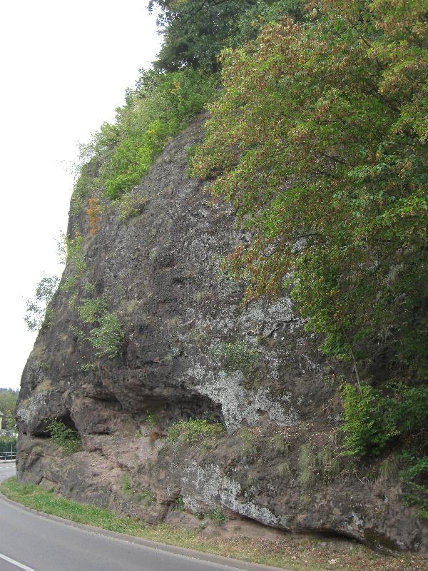
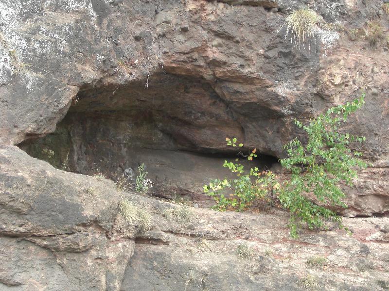
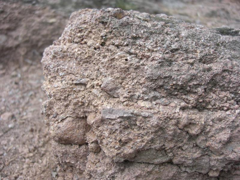
... ist der größte Aufschluss von rotbraunem Arkosesandstein (Rotliegend) im Döhlener Becken. Der gesamte Fels besteht nahezu aus einem reinen Gneis-Porphyr-Konglomerat. Dazwischen treten gut geschichtete, bis etwa einem Meter mächtige Bänke aus Sandsteinen und Schiefertonen, die fast horizontal verlaufen, auf. Durch Verwitterung von Ton sind an manchen Stellen Höhlen und Nischen entstanden, woher auch der Name Backofenfelsen rührt.
Dies ist ein Naturschutzgebiet!
Bitte verhaltet euch auch dementsprechend!
Nicht auf das Gestein klettern und keine Steine entwenden!
Seid vorsichtig an Station 1 fahren KFZ dicht vorbei!
Um loggen zu dürfen, müsst ihr folgende Aufgaben beatworten:
Station 1 (N 50° 58.994 E 013° 37.839 unten am Backofen)
1. Schätze die Maße des großen Backofenholraumes (Höhe mal Breite in vollen Metern).
2. Schätze die Dicke der untersten roten Sandschiefer-Arkose-Schicht (vor dem Gulli auf der Wiese).
3. Messe die Höhe NN am Backofen.
4. Macht optional ein Foto von euch mit dem Backofen.
Macht euch auf den Weg zum Parkplatzpunkt 2, dort beginnt der Aufstieg zur 2. Station. Vom Parkplatz 2 sind es etwa 300m Luftlinie bis zu einer Wegkreuzung, dort müsst ihr rechts.
Station 2 (N 50° 58.969 E 013° 37.529 oben auf der Aussichtsplattform)
5. Ermittle die Korngröße des Gesteins auf der Aussichtsplattform (von bis in mm).
6. Messe die Höhe NN auf der Aussichtsplattform.
7. Ermittle den Höhenunterschied von 3. und 6.
8. Welche 5 Buchstaben stehen unter der Bank auf der Aussichtsplattform?
9. Macht optional ein Foto von euch an der Aussichtsplattform.
Ihr könnt nach eurem Besuch sofort loggen.
Ihr müsst aber parallel eure Antworten per Mail an uns schicken.
Sollten die Antworten nicht stimmen, melden wir uns bei euch.
Wichtig!!!
Wir bestätigen nicht die Richtigkeit der Antworten!!!
Logs ohne Beantwortungsmail werden gelöscht!
Viel Spaß wünschen euch georg83 & Katrin
- English -
The Döhlener Becken is a landscape unit, southwest of Dresden in Saxony. It extends to a length of 22 km and a width of 6 km above the county Sächsische Schweiz-Osterzgebirge.
Already 500m towards Tharandt is the Karsdorfer Störung, it is a geological fault line / boundary in Osterzgebirge and the Elbsandsteingebirge. In height Freital Hainsberg is a constriction in the pelvis Döhlen with only about 270 meters distance between the Backofenfelsen and the First world war monument.
The Backofenfelsen (oven rocks) ...
... is the largest disruption of reddish brown Arkosesandstein (Permian) in Döhlener Becken. The entire rock is almost a pure gneiss porphyry conglomerate. There occur about a meter wide benches made of sandstones and shales, which are almost horizontal. By weathering of clay caves and niches are formed in some places, hence the name comes Backofenfelsen.
This is a nature reserve.
Please act yourself accordingly also.
Do not climb on the rocks and stones do not steal!
Be careful at station 1 cars drive by near.
To log, you have to answer the following tasks:
Station 1 (N 50 ° 58.994 E 013 ° 37.839 down of the Backofen)
1. Estimate the extent of the large Backofen (hole) (height and width in full meters).
2. Estimate the thickness of the lowest red arkose sand-shale layer (near the gully on the lawn).
3. Measure the height of sea level by the Backofen (down).
4. Optional, make a picture of you with the Backofen.
Go to the parking point 2, there begins the ascent to the 2nd Station. From the parking point 2 are about 300m straight line up to a crossroads, where you have to turn right.
Station 2 (N 50 ° 58.969 E 013 ° 37.529 on top of the viewing platform)
5. Estimate the grain size of the crumbled stones on the platform (up to mm).
6. Measure the height of sea level on the platform.
7. Estimate the height difference of task 3 and 6.
8. What 5 letters can you find under the bank on the platform?
9. Optional, make a picture of you at the viewing platform.
You can log immediately after your visit.
But you have to send your answers parallel to us by email.
If the answers do not match, we will contact you.
Important!
We do not confirm the accuracy of the answers!
Logs without reply mail will be deleted!
Have fun hope you georg83 & Katrin
Dieser Cache ist Eigentum des oben angegebenen Owners. Seine gewerbliche Nutzung setzt dessen schriftliches Genehmigung voraus.


Additional Hints
(No hints available.)