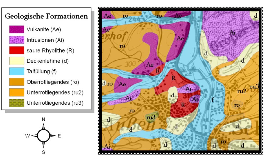
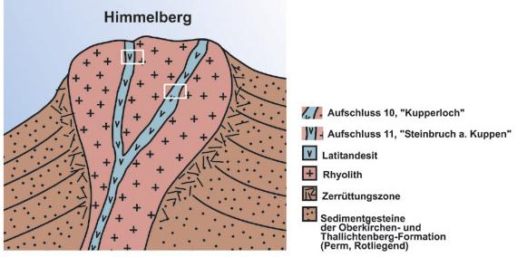
Geologie am
Himmelberg
Das Massiv des
"Himmelberges" ist geprägt durch steil abfallende Flanken und
zeichnet sich durch das Eindringen von Magma aus (Intrusion). Die
größten Aufschlüsse sind die sogenannte "Gottesbelohnung" und der
Steinbruch "Am Kuppen" mit dem alten Stollen
"Kupperloch".
Kleiner
geologischer Führer zum
"Himmelberg":
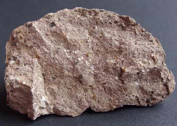
Rhyolith: eine
Wortschöpfung zusammengesetzt aus den griechischen Wörtern
"rhein" = fließen und "lithos"= Stein, ist ein
vulkanisches Gestein. Baron
Ferdinand von Richthofen hat es 1860 zum ersten Mal
wissenschaftlich besprochen. Es ist ausgesprochen reich an Quarz
und entspricht in seiner chemischen und mineralogischen
Zusammensetzung dem Granit, gilt daher auch als felsisches
Gestein.
Der
Vulkanschlot: besteht aus Latitandesit, ein
porphyrisches, vulkanisches Eruptivgestein, das Plagioklasfeldspat,
Augite, Pyroxene und Olivine enthält und die in einer Grundmasse
von Andesit und Alkalifeldspat eingelassen sind.
Randbereich: Alkalifeldspat-Trachyt, ein
vulkanisches Gestein, eingeschlossen in Sandstein der Unteren
Rotliegendserie (Tholeyer Gruppe) und bedeckt von Fanglomeraten der
Waderner Gruppe.
-
DIE AUFSCHLÜSSE
-
(1) Steinbruch "Am
Kuppen"
Vulkanschlot aus Latitandesit in der
Rhyolith-Intrusion des Himmelberges, geht im Randbereich in einen
Alkalifeldspat-Trachyt über. Schlot und Pfropfen sind gut zu
erkennen. Mit einer Länge von 100m und einer Breite von 50m
ist er kleiner als der Schlot vom Kupperloch. Die Schlote stellen
Reste von Vulkanbauten dar, aus denen die Lavadecken der Umgebung
gefördert wurden. Die Rhyolith-Intrusion des Himmelberges ist
umgeben von Sedimentgesteinen der Oberkirchen- und
Thallichtenberg-Formation (Untergruppe des Perm, Rotliegend). Im
unmittelbaren Umfeld gibt es weitere Steinbrüche.
(2)
"Kupperloch"
Ist in einen Vulkanschlot aus Latitandesit in
der Rhyolith-Intrusion des Himmelberges eingegraben. Der Schlot ist
etwa 250m lang und 100m breit. Im Randbereich des Schlotes ist die
steilstehende Laminationsklüftung deutlich abgebildet. Im
Haldenmaterial treten oft Dolomite als Fremdgesteineinschlüsse
(Xenolithe) auf. Sie sind sedimentärer Natur. Der Name "Kupperloch"
bezieht sich auf einen alten Stollen.
Logbedingungen:
1. Mache ein Photo von Dir und deinem
GPS vor dem Steinbruch bei N49° 27.037 E006° 51.145
2. Beantworte folgende Fragen und sende
die Antworten an
team-poseidon@gmx.net:
- Was ist die genaue Verwendung
für das dort abgebaute Gestein (Tafel 11)?
- Warum wachsen auf der Abraumhalde
keine Pflanzen (Tafel 10, 200m entlang der Straße)?
Achtung:
Bitte gebt keine Hinweise zu den Antworten in Eurem
Log!
(english)
The massiv of
"Himmelberg" is formed by arduous slopes and is characterized by
the irruption of magma (intrusion). The biggest outcrop is the
so-called "Gottesbelohnung" and "Am Kuppen" with the old gallery
"Kupperloch"
Small
geological guide of "Himmelberg":
Rhyolite: a neologism, consists of the
greek words "rhein"= flow and "lithos"= rock,
an igneous, volcanic rock. Baron Ferdinand von Richthofen
described it scientifically in 1860 for the first time. It is
silicia-rich and its chemical and mineralogical composition
complies with granite, that's why it is also called a felsic
rock.
The
vulcanic funnel: consists of latite-andesite, a
porphyritic, extrusive igneous rock, containing plagioclase
feldspar, augite, pyroxene and olivine, set in a groundmass of
andesit and alkali feldspar.
The boundary area:
alkalifeldspar-trachyte, a volcanic (extrusive) rock,
intruded in sandstone of the Lower Rotliegend series (Tholey group)
and covered by fanglomerates of the Wadern group.
- THE
OUTCROPS -
(1) Stone quarry
"Am Kuppen"
A volcanic funnel made up of latite-andesite
within the rhyolite intrusion of the Himmelberg, pass into alkali
feldspar trachyte in the surrounding regions. Both the funnel and
its plugs are clearly discernible. With a length of 100m and a
width of 50m, the funnel is smaller than at the Kupperloch. The
funnels are leavings of vulcanic formation, by which the fields of
lava are formed. The rhyolite-intrusion is surrounded by
sedimentary rock of Oberkirchen- and Thallichtenberg-Formation
(subcategories of Permian, Rotliegend). There are other quarries in
the nearby surroundings.
(2)
"Kupperloch"
The Kupperloch was fromed inside a volcanic
funnel made up of latite-andesite within the rhyolite intrusion of
the Himmelberg. The funnel is about 250m long and 100m wide. In the
area surrounding the funnel, the steep cracking in the lamination
of the rock can be clearly discerned. In the material of the heap
often occurs dolomite as exogenous enclosure (Xenolithe). They are
of sedimentary nature. The name "Kupperloch" refers to an old
gallery.
To log the
cache:
1. Take a photo of you and your
gps in front of the stone quarry at N49° 27.037 E006°
51.145
2. Answer the following questions and
sent the answers to
team-poseidon@gmx.net:
- What is exactly the usage of
the rocks and stones extracted from here (signage 11)?
- Why doesn't grow any vegetation on the
slag heap (signage 10, 200m along the street) ?
Attention:
Please don't give hints to the answers in your log!