Mont Ventoux
Le géant de Provence
Le Mont Chauve
Imaginez qu'à l'ère secondaire (-230 à -65 millions d'années)
il n'y avait à l'emplacement actuel du Mont Ventoux
qu'un profond bassin sédimentaire.
Au fond de cette fosse se trouvent des sédiments
de roche blanche : du calcaire.
C'est elle qui forme aujourd'hui la roche blanche
et dure du Mont Ventoux.
A la fin de cette aire, la Provence subit des mouvements
tectoniques importants qui conduisent
au plissement des chaînons provençaux et pyrénéens
selon une orientation est-ouest.
C'est au cours de la phase orogénique
(mécanisme de formation des montagnes)
de formation des Alpes que des chaînons plissés se soulèvent
et que le massif commence à prendre son aspect anticlinal déversé
et poussé vers le nord.
Au début de l'ère tertiaire, la poursuite de la collision Afrique-Europe
va doucement immeger la Provence, le Mont Ventoux,
la crête du Luberon et les Monts de Vaucluse vont devenir des îles
entourées par une vaste mer.
Lorsque s'ouvre l'aire quaternaire (-1,8 millions d'années),
la Provence redevient continentale.
Ensuite, l'alternance de glaciations et de périodes plus chaudes
donnera au Mont Ventoux son aspect actuel avec entre autres
la formation d'éboulis cryoclastiques à son sommet.
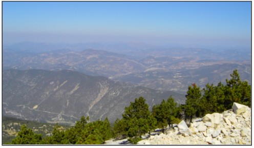
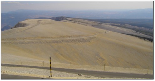
Le sommet du Mont Ventoux ressemble aujourd'hui à un désert
de roches qui est le résultat d'une érosion intense, fruit du gel en hiver
et du dégel après la période hivernale, ainsi que du vent, qui souffle
en moyenne 130 jours par an et peut y atteindre 250 Km/h !
Sources : panneaux d'information, wikipedia
Validation de cette cache
Pour valider cette cache, vous devez aller sur place et répondre
aux questions suivantes en utilisant les panneaux autour de vous.
1/ La carrière de Mazan est située à l'emplacement
du grand lac salé de Mormoiron.
Il y a combien d'année a été formé ce lac ?
2/ A Bédoin se trouve une autre carrière.
Quel élément y est exploité ? Pour quel usage ?
3/ Une plaque concerne le professeur qui a étudié
le Ventoux et en a dressé la carte géologique.
Quelle est son nom ?
A quelle période a-t'il élaboré cette carte ?
4/ Faites une photo de vous et votre GPS
sous le panneau "Mont Ventoux".
Envoyez vos réponses par mail (via mon profil)
et n'oubliez pas de mettre votre photo lors dans votre log.
Une fois vos réponses envoyées n’attendez pas mon retour pour loguer.
Je reviendrais vers vous si necessaire.
English version
Mount Ventoux
Giant of Provence
The Bald Mountain
Imagine that there was only a deep sedimentary basin in the secondary era (-230 to -65 million years ago) in the place of the current Mont Ventoux. At the bottom of this basin are white rock sediments : limestone. This rock constitutes nowadays the white and hard rock of the Giant of Provence.
At the end of this era, there was a big tectonic activity in Provence, that led to the puckering up of the Provençal and Pyrenean ranges in a East-West direction. It is during the orogenic stage (mountain building mechanism) of the Alps that the puckered ranges raised up and that the massif began to have its anticlinal and North-oriented appearance.
At the beginning of the Tertiary era, Provence has slowly immersed because of the continuation of the collision between Africa and Europe. The Mount Ventoux, the Luberon's crest and the Mounts of Vaucluse became islands surrounded by a vast sea.
At the start oh the Quaternary era (-1,8 million years ago), Provence was continental again. After that, the alternation of glaciation and warmer periods gave the Mount Ventoux its current look with the formation of crioclastic scree at its summit.
Today, the peak of the Mount Ventoux looks like a rock desert which is the result of an intense erosion due to the frost in winter and to the thaw after the wintry period as well as to the wind which blow in average 130 days in the year and can reach a speed of 250 Km/h !
Sources : information signs, wikipedia
Cache validation
To validate this cache, you have to go at the coordinates and to answer the following questions using the signs around you.
1/ The Mazan's quarry is located at the place of the big salt lake of Mormoiron.
How many years ago was this lake formed ?
2/ At Bédoin is another quarry.
What is exploited there ? What to do ?
3/ A plate refering to the professor who studied the Ventoux and developed its geological map.
What's his name ?
Wenn did he map out this map ?
4/ Take a photo with you and your GPS under the "Mont Ventoux" sign.
Send your answers per mail (through my profile)
and don't forget your photo in your log.