Koboldpfad
Beim Bau des Koboldpfades, auf dem du dich befindest, haben die Kobolde den Wettersteinkalk freigelegt, der die Felsen rund um die Leutascher Geisterklamm aufbaut. Diese Kalkfelsen enthalten Spuren, die 220 Millionen Jahre alt sind und von der Entstehung dieses Gesteins erzählen. Du kanst auf dem Weg durch entlang des Koboldpfades noch weitere interessante geologische Besonderheiten entdecken, wenn du nur aufmerksam genug hinschaust!
Wettersteinkalk und Wettersteindolomit sind die häufigsten Namen für ein Karbonatgestein aus der Mittleren Trias, der ladinischen Zeitstufe, vergleichbar der deutschen Stufe des Muschelkalks. Das Gestein ist in den ganzen Alpen verbreitet, mancherorts als Kalkstein (Calciumcarbonat), mancherorts als Dolomit mit einem zusätzlichen Anteil an Magnesiumcarbonat. Da bei der Dolomitisierung durch die Umkristallisation die Fossilspuren weitgehend gelöscht werden, sind im Wettersteindolomit die Fossilien noch schlechter, selbst im Dünnschliff kaum noch zu erkennen. Wettersteindolomit ist selten so bituminös und daher meist wesentlich reiner und hellfarbiger als der typische Hauptdolomit. Ansonsten sind keine grundsätzlichen Unterschiede zum gleichnamigen Kalk bekannt. Namensgebend war das Wettersteingebirge, weil der Wettersteinkalk hier besonders mächtige Berge bildet. Seinen Verbreitungsschwerpunkt besitzt er aber im Karwendelgebirge. In manchen Gegenden tritt ein engräumiger Wechsel von Kalk- und Dolomitfazies auf.
Logbedingungen
Um diesen Earthcache loggen zu dürfen, musst du zuerst folgende Aufgaben lösen:
Aufgabe 1: Gletscherspur
Gletscherschliffe gab es nach den Eiszeiten unzählige. Doch es ist nicht selbstverständlich, dass sie bis heute erhalten geblieben sind! Denn die Erosion verwischt die Spuren im Laufe der Zeit. Wir haben es dem lehmig-sandigen Gletscherschutt zu verdanken, der sich wie ein schützender Mantel um den nackten Fals gelegt hatte und die Ritzungen konservierte. Deine erste Aufgabe ist es ein Foto von dir und deinem Team oder deinem GPS Empfänger vor dem Gletscherschliff zu machen. Wieder zuhause, hänge dieses Foto an dein Log an! Weitere Fotos sind natürlich willkommen ;-)
Aufgabe 2: Ruf der Kobolde
Nimm Platz auf einem der Hocker oder einfach am Wegesrand und versuche dem Ruf der Kobolde zu lauschen. Du kannst dich aber auch selbst vom Klangild der Steinbrocken vor dir überzeugen und indem du sie mit dem Klöppel anschlägst. Möglicherweise lockst du dabei einen Kobold von tief unten aus der Klamm hervor! Um die folgende Frage zu beantworten, solltest du die Informationstafel genau lesen. Welcher der drei Klang-Steine wird darauf als erstes genannt? Notiere dir den Namen dieses Steins als AAAAAAAAA.
Aufgabe 3: Eingang zur Unterwelt
Du stehst hier vor einer trichterförmiger Vertiefung mitten im Wald, die einige Rätsel aufgibt. Handelt es sich um einen Spielplatz der Kobolde, einen Trichtersee der Elfen, oder um einen geheimen Eingang des Klammgeistes zur Unterwelt der Geisterklamm? Die Antwort liegt wie so oft in der Mitte. Du erfährst diese auf der Informationstafel vor dir. Hinter der Informationstafel findest du den Eingang zur Unterwelt.
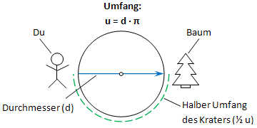
Stelle dir den Krater als Kreis vor. Bestimme nun den Durchmesser, indem du zuerst den halben Umfang an der Kante des Kraters abgehst und die zurückgelegte Entfernung in die umgewandelte Kreisformel einsetzt. Stelle dich dazu an den Rand des Kraters und fixiere einen markanten Punkt auf der gegenüberliegenden Seite (z.B. ein Baum). Wichtig dabei ist, dass die gedachte Linie durch den Mittelpunkt des Kraters führt. Zähle nun die Anzahl der Schritte, die du benötigst, um den fixierten Punkt zu erreichen. Gehe dabei in einem Halbkreis und möglichst nahe am Rand des Kraters. Am Ziel angekommen, multipliziere dein Ergebnis mit 2 um den vollen Umfang des Kraters zu bestimmen. Durch umformen der Formel des Kreisumfangs "u", kannst du den Durchmesser "d" wie folgt berechnen: d = u/PI. Der Einfachheit halber, kann PI mit 3 angenommen werden. Sende uns deinen Schätzwert per E-Mail zu.
Aufgabe 4: Kobold-Steine
Mitten im Wald schlummert ein mächtiger Fels, der wie durch das Treiben der Kobolde hierher gekommen zu sein scheint. Zusätzlich besteht er aus einem völlig anderen Gestein, als es rund um die Klamm vorkommt. Es handelt sich um einen grünlichen Granitbrocken, der einst am Julierpass im Oberengadin lag (über 200 km von hier entfernt) und mit dem Gletscherstrom auf Reisen ging. Weil es sich um fremdes Gestein inmitten der Nördlichen Kalkalpen handelt, bezeichnet man solche Blöcke als "Findlinge". An dieser Stelle findest du noch sechs weitere Gesteinsprobem. Wie lautet der Name des Steins mit der Nummer 3? Notiere dir den Namen des Steins als BBBBB.
Aufgabe 5: Kobold-Spuren
Im Urmeer lebten unzählige Organismen, wie Schalentiere, Urzeitkrebse, Korallen, Schnecken und Muscheln, aus deren kalkhaltigen Körperteilen schließlich der Wettersteinkalk entstanden ist. Links von dieser Station wirst du einen Abdruck eines Gastropoden (Schnecke) finden, ein Organismus, der seit fast CCC (notiere dir diese Zahl!) Millionen Jahren als Fossil eingeschlossen ist. Mache ein Foto von dir und deinem Team mit einem der auf der Informationstafel zu sehenden Kobold-Spuren. Wenn du alleine unterwegs bist, oder kein persönliches Bild hochladen möchtest, dann reicht auch ein Foto auf dem dein GPS mit passendem Hintergrund zu sehen ist, um diese Logbedingung zu erfüllen. Hänge auch dieses Foto an dein Log an.
Wieder zuhause sende uns eine kurze E-Mail mit dem Namen deines Teams gemeinsam mit dem Datum, an welchem du die Aufgaben gelöst hast und deiner Antwort zu Aufgabe 3, an folgende Adresse:
AAAAAAAAA-BBBBB-CCC@mus162.com
"AAAAAAAAA-BBBBB-CCC" ist ein Platzhalter, den du natürlich erst durch die Antworten auf die gestellten Fragen aus Aufgabe 2, 4 und 5 ersetzen musst. Falls deine Antworten korrekt waren, erhälst du sofort eine automatische Logreigabe zurück. Danach darfst du deinen Besuch des Koboldpfades loggen. Bitte hänge die beiden obligatorischen Fotos aus Aufgabe 1 und 5 an dein Log an!
Logs ohne Logfreigabe bzw. Fotos werden kommentarlos und ohne Ausnahme wieder gelöscht!
Goblin's Trail
During the construction of the Goblin's Trail on which you are walking, the goblins uncovered a special kind of limestone called "Wettersteinkalk" out of which all the rocks and cliffs of the Leutasch Spirit Gorge are build. These limestone rocks contain traces that are 220 million years old and tell of the origin of these rocks. You may find several interesting geological features along the Goblin's Trail, if you only pay enough attention!
Limestone is a sedimentary rock composed largely of the mineral calcite (calcium carbonate: CaCO3). The deposition of limestone strata is often a by-product and indicator of biological activity in the geologic record. Calcium (along with nitrogen, phosphorus, and potassium) is a key mineral to plant nutrition: soils overlying limestone bedrock tend to be pre-fertilized with calcium. Limestone is an important stone for masonry and architecture, vying with only granite and sandstone to be the most commonly used architectural stone. Limestone is a key ingredient of quicklime, mortar, cement, and concrete. The solubility of limestone in water and weak acid solutions leads to important phenomena. Regions overlying limestone bedrock tend to have fewer visible groundwater sources (ponds and streams), as surface water easily drains downward through cracks in the limestone. While draining, water slowly (over thousands or millions of years) enlarges these cracks; dissolving the calcium-carbonate and carrying it away in solution. Most well-known natural cave systems are through limestone bedrock.
Logging Conditions
Before you are allowed to log this Earthcache you have to accomplish the following tasks first (you may want to answer the questions below in english):
Task 1: Glacier Trace
After the ice ages there existed countless glacial striations. But most of them have disappeared because the erosion obliterated the traces in the course of time. Thanks to the clayey and sandy glacial debris which were wrapped around the bare rocks like a protective cloak, some of these carvings were preserved until nowadays. Your first task is to take a photo from you and your team or your GPS receiver in front of the glacier polish. Back home, attach this photo to your log! More photos are welcome ;-)
Task 2: Stones are not silent
Take a seat on one of the stools, or simply by the wayside and try to listen to the call of the goblins. You may also use the clapper and hit the stones in front of you. Perhaps this will lure a goblin out of a deep bottom of the gorge! To answer the following question, you should just read the information board. Which of the three sound-stones is mentioned on it first? Write down the name of this stone as AAAAAAAAA.
Task 3: Entrance to the Underworld
You're standing here in front of a funnel-shaped depression deep in the woods, which gives up some puzzles. Is it a playground of the goblins, a funnel-lake of the elves, or a secret entrance to the underworld of the Spirit of the Gorge? The answer lies as often right in the middle. You may find it on the information board right in front of you. Behind the information board you will find the entrance to the underworld.
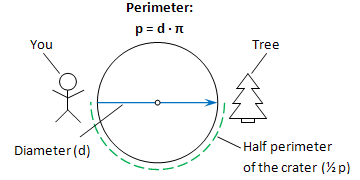
Imagine the crater as a circle. Now estimate the diameter by walking along the half perimeter of the crater and use the determined distance with the transformed circle-formula. To do so place yourself on the edge of the crater and look for a remarkable point on the other side of the crater (e.g. tree). It is important that the imaginary line passes through the center of the crater. Count the number of steps that you need to reach this point. Go there in a semi-circle and as close to the edge of the crater as possible. Upon arriving, multiply your result by 2 to determine the complete perimeter of the crater. By transforming the formula of the perimeter "p" you may calculate the diameter "d" as follows: d = p/PI. For simplicity PI can be assumed with 3. Send us your estimation by e-mail.
Task 4: Goblin Stones
In the middle of the forest there slumbers a mighty rock, which seems to have come here by the work of goblins. In addition, it consists of a completely different kind of rock, as there is nowhere else around within the gorge. It is a greenish granite rock, which originally came from the Julier Pass in Upper Engadine (over 200 km away from here), and was taken over to its current position by movement of the glaciers. Because it's a foreign rocks amidst the Northern Limestone Alps, such rocks are called "erratics." At this point, you may find six more stones. What's the name of the stone with the number 3? Write down the name of the stone as BBBBBB.
Task 5: Traces of the Goblins
Within the primordial ocean lived countless organisms, such as shellfish, primeval crabs, corals, snails and mussels. From the calcareous parts of their bodies the "Wettersteinkalk" was formed. On the left side of this stage you'll find an imprint of a gastropod (snail), an organism that is enclosed here since nearly CCC (write down this number!) million years ago as a fossil. Take a photo from you and your team in front of one of the goblin's traces mentioned on the information board. If you're traveling alone or you do not want to upload a personal picture, then a photo of your GPS receiver with a matching background is also sufficient, to meet the Logging Conditions. Attatch this photo to your log as well.
Back home send us a brief e-mail with the name of your team together with the date when you've solved the tasks and the answer of task 3 to the following address:
AAAAAAAAA-BBBBBB-CCC@mus162.com
"AAAAAAAAA-BBBBBB-CCC" is a placeholder. Of course you have to replace it by the answers to the questions of task 2, 4 and 5 first. If your answers were correct you should get an automatic log approval immediately. Then you are allowed to log your visit of the Goblin's Trail online. Please attach the two obligatory photos of task 1 and 5 to your log as well!
Logs without a valid log approval or photos will be deleted without exception and comment!