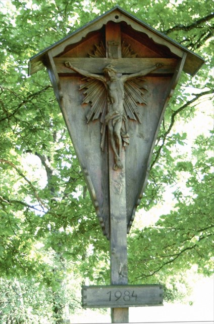
Da das Kreuz bei Station 3 immer noch fehlt, fügen wir ein Foto des Kreuzes ins Listing ein.
 Ein Hinweis zum Terrain: Ein Großteil der Strecke ist auf Asphalt- und Schotterwegen, zum Final geht es ein kurzes Stück auf Waldwegen. Der Schotter ist stellenweise recht grob, also weniger geeignet für Buggys, aber kein Problem für gut gefederte Kinderwägen. Nach sehr starken Regenfällen kann sich die Terrainwertung erhöhen, da der Weg eventuell an einigen Stellen überschwemmt wird.
Parken könnt ihr im Soiherweg bei N48° 01.242 E011° 49.161
Stage 1: Gemeindeweiher Los geht’s bei N48° 01.178 E011° 49.230. Wie viele Bretter hat die Bank unter den Bäumen? Anzahl A = ____
Stage 2: Obermeierweiher Von dort geht’s weiter nach N48° 01.A50 E011° 49.2A4. (Bitte nehmt nicht den kürzesten Weg sondern haltet euch an die offiziellen Wege.) Wie viele Birken stehen am südlichen Ufer des Weihers? Anzahl B = ____
Stage 3: Burschenweiher Geht jetzt nach N48° 01.AA5 E011° 49.4BA. Welche Zahl steht auf dem Wegkreuz? Zahl CDEF = _____
Final: Ziegelstadl Der Final liegt bei N48° 01.FCB E011° 49.(E-A)(D-B)(F+C) in der Nähe des sogenannten Ziegelstadls. Der Weiher hier ist eine von mehreren ehemaligen Lehmgruben in der Umgebung von Oberpframmern, die das Rohmaterial für die 1840 erstmals erwähnte Ziegelei von Oberpframmern lieferten. 1951 stellte die Ziegelei ihren Betrieb ein. Die Lehmgruben wurden aufgegeben und renaturalisierten sich selbst.
Der Weiher ist ein geschützter Landschaftsbestandteil. Bitte verhaltet euch entsprechend. Um den Cache zu finden, müsst ihr nicht direkt zum Weiher.
Wegen des Blätterdachs am Final können die Koordinaten ein bisschen off sein. Der Hint soll unnötiges Wühlen in Wurzeln und Pfützen ersparen. Bitte versteckt den Cache wieder gut, hier sind öfter mal Kindermuggels im Wald unterwegs.
English: About the terrain rating: Most of the route is on tarmac and gravel, the final is on a well packed dirt track. In some places the gravel is rather coarse, pushing a stroller might be difficult, but a well-sprung pram will be Ok. After strong rainfall the terrain rating goes up, as parts of the route might be flooded.
Parking is in Soiherweg at N48° 01.242 E011° 49.161
Stage 1: Start at N48° 01.178 E011° 49.230. How many boards does the bench under the trees have? Number A = ____
Stage 2: Go on to N48° 01.A50 E011° 49.2A4. (Please stay to the path and don’t take the shortcut across the field.) How many birch trees are on the southern edge of the pond? Number B = ____
Stage 3: Now go to N48° 01.AA5 E011° 49.4BA. What number do you find on the wayside cross? Number CDEF = _____
Final: The final is at N48° 01.FCB E011° 49.(E-A)(D-B)(F+C), a location called “Ziegelstadl” (brickworks) by the locals. The pond is one of several former clay pits around Oberpframmern, which supplied material to the brickworks of Oberpframmern (first mentioned in 1840). In 1951 the brickworks ceased manufacturing. The clay pits fell into disuse and are being reclaimed by nature.
The pond is a protected nature preserve. Please treat the area carefully. You don’t have to go very close to the pond to find the cache.
At the final, the coordinates can be a bit off because of foliage. The hint is intended to avoid unnecessary damage to roots and trees. Please hide the cache carefully as children use the forest as a playground.