 For 100 years, the National Park Service has preserved America’s special places “for the enjoyment, education, and inspiration of this and future generations.” Celebrate its second century with the Find Your Park GeoTour that launched April 2016 and explore these geocaches placed for you by National Park Service Rangers and their partners.
geocaching.com/play/geotours/findyourpark
Twenty-five miles of the 360 mile long Green River flow through Mammoth Cave National Park. Green River has an average width of 75 feet, and an average depth of 10 feet with holes of 30 feet. Shallows, sandbars, islands, and subsurface springs are numerous. Kentucky’s Green River has played and continues to play an integral role in the development of the Mammoth Cave system.
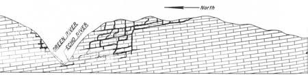
Despite an average rainfall of about 50 inches, other than the Green and Nolin Rivers, there are very few surface streams in the area of Mammoth Cave. Numerous streamless valleys in the park area look exactly like any other steep-sided stream valleys except that none of them has a stream of permanently flowing water in it. When rain falls, the water passes rapidly underground through sinkholes and joints (known as karst topography) in the subsurface limestone. Surface streams enter these areas and flow through the continuously dissolving underground channels, seeking the lowest level. Active circulation of underground water is essential to mineral solution and the formation of caves. In order for the water to flow, there must be some outlet again at the surface, otherwise the water would simply pool and fill the underground spaces. The valley of the Green River and its tributaries supply the needed outlet. This illustration shows how the water can flow downward through the limestone layers, and emerge at the surface in the Green River valley.
http://www.nps.gov/history/history/online_books/geology/publications/state/ky/kgs-sp-7/contents.htm
In addition, because the water reaches the surface in the Green River valley, this valley also defines the northern boundary of the Mammoth Cave system.
Echo River drains Mammoth Cave’s lowest level, emerging 360 feet below the surface to empty into the Green River. As the Green River erodes the valley deeper, the Mammoth Cave system will also continue to develop deeper into the limestone layers.
The level of the Green River also controls the level of the Echo River within the cave. The 1906 construction of a lock and 9 foot dam downstream on the Green River at Brownsville, KY has raised the water level in some parts of the Mammoth Cave system by as much as six feet above its natural level.
Here is the web address for the webcam located at GZ:
http://www.youtube.com/watch?v=x3TR-o7dnlY
Here is another web address for the webcam located at GZ, that generates a photo that periodically updates (thanks to KY Hiker):
http://www.nature.nps.gov/air/webcams/parks/macacam/macacam.cfm
To get credit for this Earthcache, go to the posted Earthcache coordinates and take a picture with the Green River in the background, and e-mail me the answers to the following questions:
1. How many feet in elevation has the water flowed from the surface above Mammoth Cave to its emergence through the Echo River to the Green River?
2. What geological feature defines the northern boundary of the Mammoth Cave system?
3. Describe how the dam downstream on the Green River has affected the Mammoth Cave system.
4. What animal is pictured and described on the lower left of the interpretive sign at GZ? (Do not include this interpretive sign in your picture or your picture may be deleted at my discretion.)


I have earned GSA's highest level. Go to earthcache.org to find out how you can become an EarthCache Master, too.