Nationalparken Blå Jungfrun
Blå Jungfrun är en isolerad ö som med sin magnifika form och höjd skiljer ut sig från övriga öar i Kalmarsunds skärgård. Denna granitkupol reser sig 86 meter över havet och 130 meter över havsbottnen. Sedd från fastlandet eller från Öland avtecknar sig Blå Jungfrun som en gråblå siluett långt ute i havet. Med tanke på öns avskildhet och färgen på dess siluett är det inte konstigt att Blå Jungfrun blivit sagornas och folktrons Blåkulla. Redan vid 1400-talets början omtalades ön som Blåkulla och omgavs med magiska föreställningar om häxor och trolldom.
Geologiskt sett är Blå Jungfrun unik, en ensam kupol av rödgranit mellan fastlandets Smålandsgranit och Ölands kalkberggrund. Den röda färgen kommer av mineralet kalifältspat.
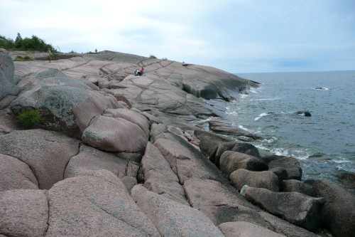
Öns landskap domineras av granithällar. Dessa har genom årtusenden slipats av is och vatten till den jämna och nästan sprickfria yta vi kan uppleva idag. På Blå Jungfrun finns det flera jättegrytor. Detta är geologiska fenomen skapade över lång tid av vattnets rörelser mot klippan.
Nationalparker och naturreservat bildas för att skydda och bevara värdefull natur och kulturmiljö. Många gånger finns det också vetenskapliga syften till avsättandet. Blå Jungfrun ger framför allt goda möjligheter till geologiska studier. För ca 500 miljoner år sedan, under perioderna Kambrium och Ordovicium var granitkupolen täckt av sediment. Rester av detta sediment kan man idag se som sprickfyllnad i området vid nedre västra stenbrottet.
Den runda profil ön har idag skapades först genom inlandsisarnas slipande för någon miljon år sedan under den tidsperiod som kallas Kvartär. Blå Jungfruns konturer finputsades sedan mellan 6 900 - 5 000 f kr. Då var Östersjön ett innanhav, den sk Ancylusjön, med en vattennivå mycket högre än idag. De stora blockmarkerna på öns södra del är intressanta för både geologer och besökare i allmänhet.
Platsen för cachen är Sikhamnsgrytan.
Regler för loggning:
* Skicka ett meddelande till ägaren med svaren på dessa frågor:
1. Beskriv hur jättegrytorna bildats.
2. Uppskatta hur djup jättegrytan är, lämpligen genom att jämföra med dig själv på ett foto
* Logga found - MEN inget av svaren i loggen tack, däremot får du gärna bifoga ett foto
 The National Park Blå Jungfrun - An ancient granite dome
The small island Blå Jungfrun (the Blue Maiden) rises like a granite dome in Kalmarsund (the Kalmar Straits), 86 metres above sealevel and 130 metres above the sea floor. Bare cliffs and red granite slabs and odtcrops predominate. The south slopes are clad with dense oak woods, with some linden, maple and aspen. In rocky clefts and among the stone slabs may be found pine, spruce and birch trees. The red granite is geologically unique in the area between Ölands limestone and Smålands grey granite
The island's landscape is dominated by granite slabs. These have been through millennia been polished of ice and water until the smooth and almost crackless surface we can experience today. At Blå Jungfrun, there are several giant potholes. This geological phenomenon was created over a long period of water movements against the rock.
Later on both the forest and plant life suffered the impact of drought and the depredations of introduced rabbits. But the worst damage was caused by the quarrying that began in 1904. It was then that the largest of the great caves was blown to pieces.
After World War I powerful forces were mobilised to save the island. With the help of a donation by Torsten Kreuger it was purchased and handed over to the state for dedication as a national park.
National parks and nature reserves preserve the natural and human environmentand almost always also serve scientific interests. Blå Jungfrun offers good opportunities for geologieal studies. It is possible to observe how the granite dome was covered by sediment about 500 million years ago (during the Cambrian and Ordovician geological periods), how the island took shape about a million years ago (during the Quaternary Ice Age) and how its contours were given a final polish by Lake Ancylus (the Baltic Sea in its fresh water phase, circa 6900 5000 BC). Of general interest to geologists and other visitors are the large boulder fields in the south of the island.
The place for the cache is the big pothole called Sikhamnsgrytan
Rules for logging:
Send a message to the owner, with answers of two questions:
1. Describe how the giant potholes was created
2. Estimate how deep the pothole is, preferable by compare with yourself on a photo
None of these answers in the log please, except a photo, which is appreciated