Lake Pend Oreille
OVERVIEW:
Throughout the earth's history the climate has
fluctuated and at times the temperatures have been cooler than they
are now. This change in temperature can last anywhere from 2 to 10
million years and is referred to as an ice age. During an ice age
the snow begins to accumulate at higher elevations in the mid to
upper latitudes. Due to the cooler temperatures during the ice age,
the snow does not completely melt during the summer months. The
snow accumulates, compacting under its own weight and forming
glaciers that flow like slow moving rivers of ice down the valleys
and into the plains, spreading out across the continent. Comment:
during the last Ice Age (Pleistocene Epoch), which lasted about 2
million years, interglacial conditions – like today’s,
prevailed for about half the time.
HISTORY:
Lake Pend Oreille in northern Idaho is a fascinating
geomorphic feature. This lake, at about 1158 feet is the deepest by
far in the region, lies in a basin formed by Cordilleran
glaciations immediately below the site of the ice dam that
repeatedly formed Pleistocene Glacial Lake Missoula. The
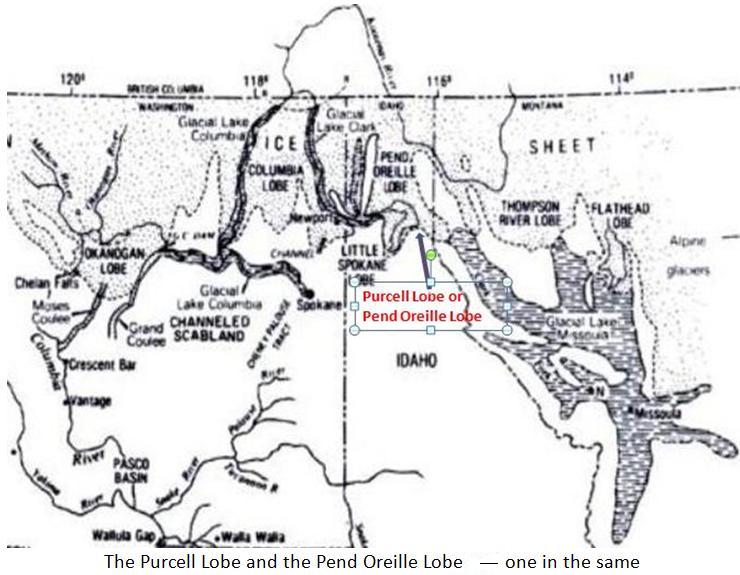
Cordilleran Ice Sheet extended farthest along major south-trending
valleys and lowlands, forming several composite lobes segregated by
highlands and mountains. Looking south to southeast from the posted
coordinates of this Earthcache, you are provided with a vista of
the intersection of the Clark Fork valley and the Purcell Trench as
well as the area of the Clark Fork ice dam and Lake Pend Oreille
trough.
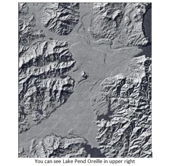
The Purcell Trench, a major topographic depression
in British Columbia and northern Idaho, is incised into the margin
of a metamorphic and granitic complex, formed during Mesozoic
convergent tectonics, but later subjected to Eocene extension. The
trench is bounded on the west by the Selkirk Range and on the east
by the Cabinet Mountains. The Purcell Trench has been the site of
several drainage reversals. Prior to the Miocene time, ancestral
river ranges flowed within the Purcell Trench from the Canadian
border south to the Coeur d’Alene area in a meandering
pattern following the least resistant rock exposures and fault
zones. This pattern is still apparent in the present day meandering
shape of Lake Pend Oreille.
During Miocene time the Columbia River Basalt
Group invaded the southern part of the trench and formed a
lava-dammed lake with water levels up to 2400 ft above sea level.
However, the basalt dam eventually was eroded, restoring southward
drainage. During the Pleistocene era, the Cordilleran ice advancing
into Lake Pend Oreille repeatedly blocked the Clark Fork drainage
and formed Glacial Lake Missoula.
The terminus of the glacial extended to the southern
end of the lake and upon each failure of the ice dam, much of the
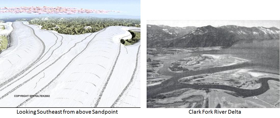
catastrophic flood discharge was directed through the lake basin
and into the Rathdrum Prairie (as seen in the photo below).
Paleomagnetic analysis of the lakes filling and emptying cycles
near the dam and in Lightning Creek shows secular variation in each
of the lake filling cycles, but the analysis shows none within the
instantaneous flood cycles.
After the latest flood (15-12,000 years ago), the
Pend Oreille basin was again reoccupied by a glacier but this
advance did not result in catastrophic lake drainage. Terminal
deposits of till at the southern end of Lake Pend Oreille are
undisturbed. Proglacial deltas and kame terraces in the Clark Fork
valley left by this advance are intact and therefore postdate the
catastrophic Missoula floods.
There have been at least five major ice ages in the
past one billion years. The most recent, the Pleistocene Ice age,
began about 2 million years ago. Glaciers did not continually cover
the earth during this time; there have been interglacial periods
where temperatures warm slightly and the glaciers melt and
retreat.
In the most recent advance, glaciers reached
their maximum extent about 18,000 years ago and had completely
receded by 12,000 years ago. It was during this last glacial
advance that a finger from the glacial ice sheet moved south
through the Purcell Trench in northern Idaho, near present day Lake
Pend Oreille, damming the Clark Fork River creating Glacial Lake
Missoula. But that’s another
subject.
Definitions:
Basalt: A dark volcanic rock. The most common type of lava.
Cordilleran: Referencing the extensive chain of mountain or
mountain ranges, especially the principal mountain system of a
continent.
Eocene Epoch: An interval of geologic time. The second epoch of the
Tertiary Period, from about 58 to 37 million years ago.
Glaciation: the process of covering part of the earth's surface
with glaciers or masses of ice.
Geomorphic: Of or resembling the earth or its shape or surface
configuration. Pertaining to landform creation.
Mesozoic Era: The interval of geologic time from about 245 to 65
million years ago.
Miocene Epoch: The fourth epoch of the Tertiary Period, from about
24 to 5 million years ago.
Paleomagnetic: The study of the record of the Earth's magnetic
field preserved in rocks and sediment through
time.
References and pictures:
Website -Ice Age Flood Institute - http://www.iafi.org/index.htm
The Restless Northwest – A Geological
Story – Author, Hill Williams
Roadside Geology of Idaho – Authors,
David D. Alt & Donald W. Hyndman
On the trail of the Ice Age Floods – A
geological field guide to the Mid-Columbian Basin - Author, Bruce
Bjornstad
http://en.wikipedia.org/wiki/Lake_Pend_Oreille
************************************************
To log this cache, you
must first email Rolling
Oldies the answer to these two questions and post a picture: Please do not include the answers to
the questions in your on-line logs, either in the clear or
encrypted.
- At this location; Estimate how many feet
above the lake you are.
- Estimate the distance from this location
to Warren Island.
And -I am requesting that, if possible attach
a picture of you, and/or your group with your GPSr to your FOUND IT
log.
Only the answers are required, and
you need not wait for a reply from me before logging, but logs
without the proper email will be
deleted.
|