Close to Kirkjubaejarklaustur, there’s Fjaðrárgljúfur, a canyon that the river Fjaðrá hollowed out during two millions of years since the Ice Age. It is surrounded by green areas and from there you can enjoy a breathtaking view on the plain beneath.
At the parking place you can find a sign with this text:
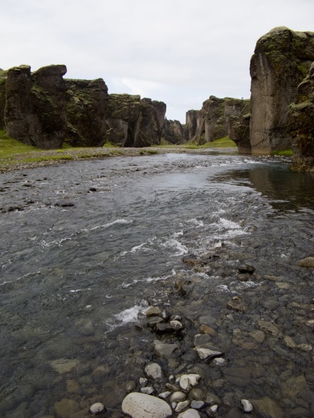
Fjaðrá is a magnificent and massive canyon, about 100 meters deep and about one kilometers long. The canyon has sheer walls, and is somewhat serpentine and narrow. The bedrock in Fjaðrá is mostly palagonite from cold periods of the Ice Age and is thought to be about two million years old.
The river Fjaðrá has its source in the mountain Geirlandshraun and falls off the heath edge in this stunning canyon until it makes it down into Skaftá river. Fjaðrá has changed a lot in the course of time. Today Fjaðrá is often rather low in water and therefore hikers can safely choose to walk inside the canyon. However, wading is necessary fairly often. Deep in the canyon there are waterfalls so one needs to walk the same way back, Most people choose to walk along a walking path up in the canyon's edge while simultaneously enjoying the view above the canyon. Fjaðrárgljúfur is on the Nature Conservative Register.
Formation of the Fjaðrárgljúfur canyon:
The canyon is believed to have formed during the end of the last Ice Age around nine thousand years ago. As the glacier slowly retreated, a lagoon was formed in the valley behind a hard resistant rock. The run-off started slowly digging into the landscape where the canyon Fjaðrárgljúfur is presently located. Glacial rivers carried large amounts of sediment into the lagoon and the river running from it dug itself into the rock threshold and the (answer A) layers in front. Because the cascade has been so large, it was powerful in digging out the canyon. Eventually the lagoon filled with sediments and the river's strength dwindled. When the lagoon filled up completely, the river began to dig itself into the sediment layers which it has previously left in the valley. (answer B) terraces left behind give evidence of the original height and location of the lagoon and a deep channel in the palagonite bears silent witness to the forces of nature.
The gorge runs through hyaloclastite (soft granular rock) with lava layers and intrusions. Hyaloclastite is a hydrated tuff-like breccia rich in black volcanic glass, formed during volcanic eruptions under water, under ice or where subaerial flows reach the sea or other bodies of water. It has the appearance of angular flat fragments sized between a millimeter to few centimeters. The fragmentation occurs by the force of the volcanic explosion, or by thermal shock during rapid cooling.
Several minerals are found in hyaloclastite masses. Sideromelane is a basalt glass rapidly quenched in water. It is transparent and pure, lacking the iron oxide crystals dispersed in the more commonly occurring tachylite. Fragments of these glasses are usually surrounded by a yellow waxy layer of palagonite, formed by reaction of sideromelane with water.
How to get there:
You may arrive to this area walking over the lava streams from the village of Hringvegur, or by car taking road 206 and passing by the Laki volcano.
How to log this cache:
- Email us (answer A) and (answer B) from the explanation above which you can find on a sign at the parking place (N63 46.268 W18 10.305).
- Describe the canyon in a few words on your own.
Does the river flow straight or rather more like a snake?
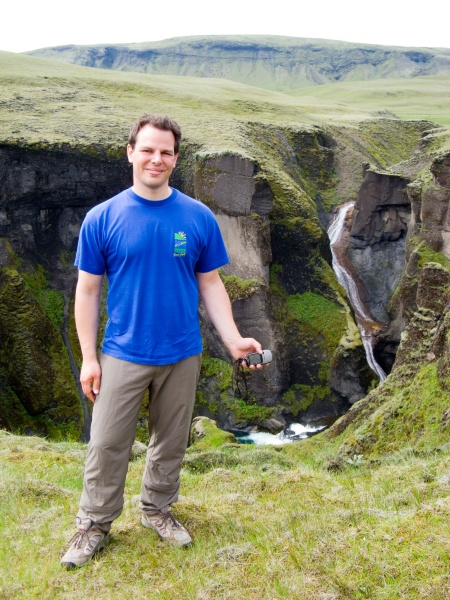
Is the way along the canyon rising, falling or staying at the same altitude while walking to N63 46.719 W18 10.558 starting from the parking place?
What's the colour of the stone?
What kind of plants are growing here?
- Take a picture of you (with or without GPS) on the top of the canyon at N63 46.719 W18 10.558 and attach it to your log. (optional)
- Enjoy the view!
Send your answers per mail to
GC1W9TG-(answer A)-(answer B)@gmx.de e.g. GC1W9TG-formation-high@gmx.de
before logging the cache! In case of correct answer you will get an automatic response mail. Please also check your spam folder if you don't receive the response mail.