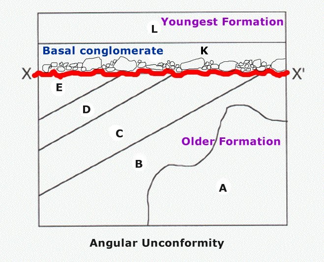
An unconformity is a buried erosion
surface separating two rock masses or strata of different ages,
indicating that sediment deposition was not continuous. In general,
the older layer was exposed to erosion for an interval of time
before deposition of the younger, but the term is used to describe
any break in the sedimentary geologic record.
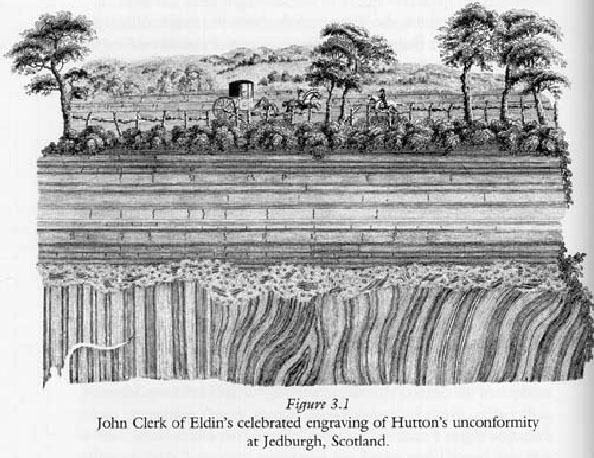
The phenomenon of angular unconformities was
discovered by James Hutton, who found examples at Jedburgh in 1787
and at Siccar Point in 1788.
The rocks above an unconformity are, generally,
younger than the rocks beneath (unless the sequence has been
overturned). An unconformity represents (a lot of) time during
which no sediments were deposited and the local record for that
time interval is missing and geologists must use other clues to
discover that part of the geologic history of that area. The
interval of geologic time not represented is called a hiatus. There
are four types of unconformities: disconformity, nonconformity,
angular unconformity and paraconformity.
Siccar Point is historically the most important
unconformity and is a rocky promontory in the county of
Berwickshire on the east coast of Scotland. It is famous in the
history of geology as a result of a boat trip in 1788 in which
James Hutton, with James Hall and John Playfair, observed the
angular unconformity which Hutton regarded as conclusive proof of
the theory of geological evolution. During this year (2009) we are
celebrating Charles Darwin bicentenary, it seems very important to
remember that some Geological relevant information leads and helps
the Darwin’s theory of evolution !!!!!!
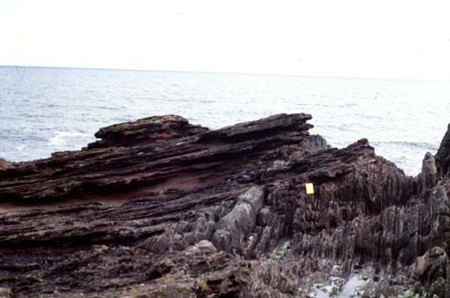
One of the most important and well exposed
unconformities along this SW Variscan Chain is the so called
Telheiro beach unconformity. The problem involving the placing of
an Earth cache in the local (Ponta Ruiva) is that the cliffs and
the tides are very, very dangerous!!!

The unconformity of Praia de São Torpes
(Sines - SW Portugal)
The unconformity of the São Torpes beach can be
observed along the coastal boarder, between Sines and Vila Nova de
Mil Fontes. It represents an enormous time interval (more then 100
M.y. – million years) during which a variety of complex
geological processes took place. Along this angular unconformity
two very different groups of rocks suddenly contact. These two rock
types were formed at distinct times and by very diverse
mechanisms.
The lower, older, group is composed by shales
and graywackes while the upper, younger, group is represented by
sandstones and basal conglomerates. According to the Tectonic Plate
theory, between the sedimentation of the two groups of rocks took
place the closure of a primeval ocean with the subsequent folding
and metamorphism of the sediments he gathered during millions of
years, giving rise to enormous mountain ranges which led to the
constitution of the supercontinent Pangaea, at the end of the
Paleozoic Era.
Afterwards erosion took place cutting through
the mountains until a completely flattened surface was left,
materialized by the soft contour of the unconformity surface.
The observation and interpretation of this type
of geological evidences led XIX century naturalists, including
Charles Darwin, to acquire a much more enlarged notion of our
planet’s antiquity. An unconformity is defined whenever two
very distinct types of rocks, formed a two separate moments
(distant in time around 100 Million years, in this case) and by
very diverse geological processes, come in contact with/to each
other.
It is an angular unconformity because the
underlying rocks became deformed and their layers form a certain
angle relative to the overlaying rock layers. The shales and
graywakes (Baixo Alentejo flysch Group) were formed under low grade
regional metamorphism conditions from clays and clayish sands
deposited more than 330 million years ago (Late Carboniferous), at
the seabed of a deep ancient ocean.
The sandstones and conglomerates (Grés de Silves
formation) formed by the sedimentation of very coarse conglomerate
sands, 230 million years ago (Late Triassic), by small rivers and
creeks in continental arid conditions with long dry spells
alternating with sudden floods. Conglomerate is a sedimentary rock
consisting of individual clasts within a finer-grained matrix that
have become cemented together.
Conglomerates derived always from an erosive
period of time and are formed of rounded fragments (some times very
big – boulders) and are thus differentiated from breccias,
which consist of angular clasts. Both conglomerates and breccias
are characterized by clasts larger than sand (< 2 mm). (See
also GC1D9RH - Conglomerate - DP/EC19 by danieloliveira,
Lisboa)
The cache
This cache takes you to the southernmost part of
São Torpes beach – South Sines cape. The outcrop in GZ could
be easily identified. In order to log your find, your task is
answered the following questions:
1- Measure the dimension of the biggest boulder
of the conglomerate above the unconformity.
2- Tell us the colour of the ancient formation
(more deformed)
3- And the colour of the matrix of the youngest
litologies (the main cement of the conglomerate)
4- Finally – not a question! - take a
picture of you and/or your GPS’r on the top of the biggest
boulder (it seems a small seat), with two big electric power
station chimneys behind.
Answers by the e-mail not in the log.(Using my
profile to send).
The photo should be placed on the log after
confirmation that the answers are correct. Log without photo or log
without authorization will be erased. Please quote the
reference/name of the cache in your answers.
Em Português - A cache
Esta cache vai levá-lo até ao extremo sul da
praia de São Torpes – a Sul do Cabo de Sines. O afloramento
rochoso no ponto 0 é facilmente identificável. Para reclamar o log
desta cache, o objectivo é responder às seguintes perguntas:
1- Medir as dimensões do maior calhau de
conglomerado acima da discordância angular.
2- Dizer-nos qual a cor da formação geológica
mais antiga (mais deformada)
3- E a cor da matriz e do cimento das litologias
mais recentes (o cimento do conglomerado)
4- Finalmente – não é uma pergunta! - tire
uma fotografia consigo e/ou com o seu GPS'r por cima do maior dos
calhaus do conglomerado (que até parece um "banquinho"), de modo a
que também se vejam as duas chaminés da Central de Sines ao
fundo.
As respostas devem ser enviadas por correio
electrónico e não podem ser colocadas no log.(Usem o meu perfil
para o envio).
A fotografia deverá ser colocada juntamente com
o log depois da confirmação de que as respostas estão correctas.
Log's sem autorização e sem fotografia serão apagados. Quando
responder às perguntas por favor refira-se na resposta a qual
Earthcache nome/número está a responder.