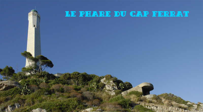
Construit en 1732, le phare, était destiné à remplacer
l’ancienne tour à feu du XVIème siècle. Détruit en 1944, il
fut reconstruit sous sa forme actuelle après la guerre. Il offre un
panorama unique qui s’étend de l’Estérel jusqu’à
la côte italienne. Le phare est aujourd’hui fermé au
public.
L'idéal pour découvrir le Cap Ferrat est d'emprunter les 7 km de
sentier pédestre qui a été aménagés autour de la presqu'île. Durée
environ 1h30.
Départ village de St Jean, La Carrière Parking - Plage du port. De
la place du Centenaire, remonter la rue commerçante puis prendre à
gauche l’avenue Claude Vignon. 50 mètres après le jeu de
boules débute le chemin de la Carrière ainsi nommé à cause
d’une ancienne carrière où furent extraites les pierres qui
servirent pour la construction du Port de Monaco (1896-1906). Le
chemin longe la côte en passant en contrebas du Grand Hôtel du Cap
Ferrat et de sa piscine olympique, avant d’atteindre le phare
et la pointe Malalongue. Au pied du phare, magnifique vue sur le
cap de Nice et l’Estérel par temps clair. Vous voici sur le
versant ouest de la presqu’île. Les criques se succèdent
jusqu’à la plage de Passable, face à la rade de Villefranche
sur mer avec sa citadelle dominée par le château du Mont Alban.
Quelques marches terminent la promenade. Prendre à gauche pour
rejoindre la plage de Passable, emprunter l’escalier de la
plage et remonter le Chemin de Passable pour arriver sur
l’avenue Denis Séméria. Tourner à droite, passer devant
l’office de tourisme et continuer l’avenue Denis
Séméria pour rejoindre le village.
Built in 1732, the lighthouse was intended to replace the old
open fire tower from the sixteenth century. Destroyed in 1944, it
was rebuilt in its present form after the war. It offers a unique
panorama which stretches from the Estérel up the Italian coast. The
lighthouse is closed to the public.
The perfect way to explore the Cap Ferrat is by the 7 km footpath
which has been built around the peninsula. Duration approximately
1h30.
Departure from. the village of St Jean, Carrière parking, Plage du
port. From the Place du Centenaire, walk up the street and then
turn left on the Avenue Claude Vignon. 50 meters after the "Boules"
playing area begins the Chemin de la Carrière, which got its lame
from an old quarry where the stones were extracted to be used for
the construction of the Port of Monaco (1896-1906). The road hugs
the coast, passing below the Grand Hotel du Cap Ferrat and its
Olympic swimming pool, before reaching the lighthouse and the Cape
Malalongue. From the foot of the lighthouse, you have a great view
on the Estérel and the Cap de Nice by clear weather. You are now on
the western side of the peninsula. Follow the track to the Passable
beach, facing the bay of Villefranche sur Mer with its citadel
dominated by the castle of Mont Alban. From Plage de Passable, take
the stairs up to Chemin de Passable and continue on Avenue Denis
Séméria. You will pass in front of the tourist office to reach the
village and the parking.
SVP prenez le temps de bien
recouvrir la cache pour éviter les
pillages.
Please kindly take the time to cover
the cache well again to avoid muggling.