Passo Valles: an open-air geological museum EarthCache
Passo Valles: an open-air geological museum
-
Difficulty:
-

-
Terrain:
-
Size:  (not chosen)
Please note Use of geocaching.com services is subject to the terms and conditions
in our disclaimer.
Passo Valles: an open-air geological
museum
This earthcache was created to celebrate the inclusion of the
Dolomites in the World Heritage List by the United Nations
Educational Scientific and Cultural Organization (UNESCO). This
announcement refers to the beauty of these mountains, their
diversity on landforms, the importance of dynamic processes and
fossil records. The purpose of this earthcache is to introduce the
geocacher to the geology of the Dolomites, showing some types of
rocks present in this area. For this purpose, I select one of the
most interesting places in the Dolomites from a geological point of
view: Passo Valles (2032 m).
The Dolomites comprise a mountain range in the northeastern Italian
Alps, covering about 142,000 ha, and relatively well confined from
the physiographic point of view (Figure 1). They feature some of
the most wonderful mountains anywhere, with typical sheer cliffs
and narrow, deep and long valleys. The Dolomites are also
characterized by a great variety of environments and a great
variety of different habitats. This fact allows a great richness in
animal and vegetal forms, some of which are endemic species, rare
species, or species with a great biological value.

Figure 1. Location of the Dolomites in the Eastern Alps
(Source: Wikipedia, http://en.wikipedia.org/wiki/Dolomites).
The Dolomites are also very important from a geological point of
view, because composed by several different rocks originated in
various geologic periods and forming complex and interesting
stratigraphic series. With this earthcache, I would to take the
geocacher for a walk through the geological history of the
Dolomites. The cache is composed of 6 waypoints. You can visit 4
waypoints (1, 2, 5 and 6) with your car and 2 waypoints (3 and 4)
with a little walk near Passo Valles (approx 500 m return). This
cache take about 1 hour. See the map on Figure 2. Reading the
following text and looking for the waypoints, you can see some
rocks and you can learn the information to reply to some questions,
absolutely mandatory to log this cache. Remember the ethics
"leave no trace"... please
respect the nature and don't remove the rocks!
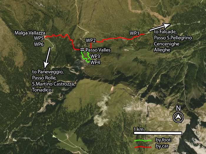
Figure 2. The earthcache location with the WPs.
Waypoint 1 - Porphyries (N 46°20.464; E 11°48.890). During
the Early Permian (299-271 million years ago), a great volcanic
system originated a great amount of ashes. The deposit of the
pyroclastic flow, a hot suspension of particles and gases that
flows rapidly from a volcano, created the oldest rock you can see
at Passo Valles: the ignimbrite, the most common type of Porphyry
on Earth's crust, an extrusive igneous rocks. The accumulation of
volcanic ashes resulted in the formation of a thick volcanic
package covering over 2000 km2, with a thicknesses
locally exceeding 2000 m. Ignimbrite has a dark red color, and it
is primarily composed of a matrix of volcanic ashes with fragments
of volcanic glass, pumice fragments, and crystals (Figure 3).
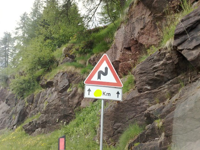
Figure 3. Ignimbrites at waypoint 1.
Waypoint 2 - Gardena Sandstone (N 46°20.417; E 11°48.229).
During the Late Permian (260-251 million years ago), the ending of
the volcanic processes allowed the erosion of the porphyries and
then the transport and deposition of fragments by rivers. A red
beds of sediments deposited in a semi-arid setting of alluvial fans
and formed the Gardena Sandstone, a sedimentary rock composed
mainly of sand-size mineral or porphyry grains. Due to their
origin, this sandstone has the same color as the ignimbrites
(Figure 4).
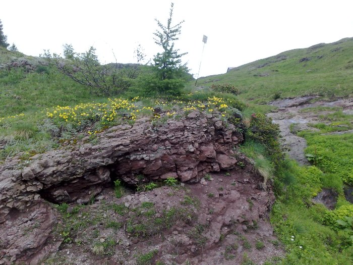
Figure 4. Gardena Sandstone at waypoint 2.
Waypoint 3 – Gypsum, Bellerophon Formation (N
46°20.226; E 11°48.087). Approx 255-260 million years ago, the sea
invaded the mainland (marine transgression process) leading to the
formation of depositional environments, as coastal sabkha, lagoons,
saline deposits and shallow shelves. In this way, shallow marine
evaporites and carbonates were originated, the so-called
Bellerophon Formation. Now, you need to park your car at the
original earthcache coordinates: The next two waypoints are
accessible only by foot. At waypoint 3, you can see the gypsum
(Figure 5), probably originated in a lagoon from the evaporation of
surficial water.
Waypoint 4 – Grey Marlstone, Bellerophon Formation (N
46°20.132; E 11°48.131). At waypoint 4 you can see some grey
marlstone, a calcium carbonate or lime-rich mud or mudstone which
contains variable amounts of clays (Figure 6).
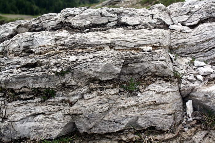
Figure 5. Gypsum at waypoint 3.
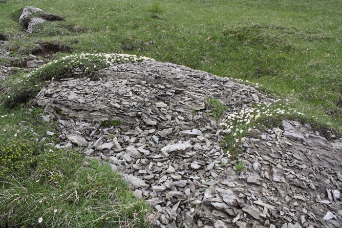
Figure 6. Grey marlstone at waypoint 4.
Waypoint 5 – Werfen Formation and Sciliar Dolomite (N
46°20.473; E 11°47.445). During the Lower Triassic (approx 251
million years ago), a thick sequence of shallow-water carbonates
and terrigenous deposits overlies the Bellerophon Formation. This
very complex and heterogeneous sequence of grey dune limestone,
grey-red siltstones and sandstones is called Werfen Formation. To
reach this waypoint you need to return at Passo Valles and take
your car. From waypoint 5, near the Malga Vallazza, look to SE to
see the Cima Valles (2305 m). In the lower part, you can see some
badlands, a type of geomorphologic feature where softer Bellerophon
Formation have been extensively eroded by rain water. Do you see
the complex stratigraphic texture? Moreover, in the upper part you
can see some rock of the Werfen Formation (Figure 7).
During the Late Anisian period (approx 235 million years ago) a
regional drowning due to the subsidence processes, created
shallow-water environments, with several small isolated islands.
This downing process was slowly sinking islands, where start to
live some organisms forming a primitive coral reef. This subsidence
caused relative sea level changes sufficient to drown coral reefs.
However, these organisms have been able to grow fast enough to
avoid drowning by subsidence. The growing of the colony rapidly
reached a thickness of 800–900 m. This material created some
of the most famous Dolomite Mountains, such as Sciliar, Latemàr,
Marmolada, Catinaccio, Pale di S. Martino, Odle, Putia and the
lower part of Civetta. The Dolomite is a sedimentary carbonate rock
composed of calcium magnesium carbonate
(CaMg(CO3)2). From this waypoint you can see
the Pale di San Martino looking at SSE (Figure 8).
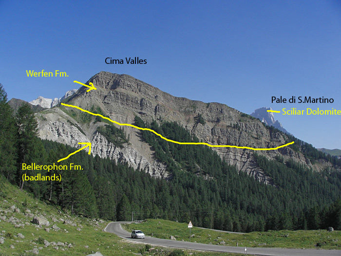
Figure 7. Cima Valles from Malga Vallazza, waypoints 5 and
6.
Your little tour in the history of the Dolomites is terminated.
Now, you can reply to some questions. Therefore, the Dolomites
history continue… see the additional information.
To log this EarthCache you must first email me via the profile
or directly to mauro78.geocaching@gmail.com,
with the answer to the following questions:
1) Near waypoint 1, you can see a road sign (Figure 3, yellow
covered area): how many kilometers?
2) How many flagpoles you can see near the Passo Valles parking (at
original earthcache coordinates)?
3) Which rocks originated during the Late Permian period?
4) Which rock formations are visible in the badlands on waypoint
6?
5) What is the chemical formula of the Dolomite?
When you receive a confirmatory email, log this earthcache
uploading a photograph of any rock or any geological feature you
found interesting. I appreciate if you also include the waypoint
and a brief explanation in your log. Good luck!
Mauro
Additional information
The Dolomites history continue… Approx 230 million years
ago, two new volcanoes arise from the ocean (one near Predazzo and
one near the Velle S. Niccolò) originating a great amount of lava
and tuffs and pouring down the sea basins and onlapping the
platform slopes. Some mountains are totally or partially formed by
these volcanic rocks, e.g., Mt Padon, Mt Pore and Col di Lana. Most
of the coral reefs was killed (e.g., Latemàr, Marmolada) being
close to the volcanoes and were even buried to the volcanic
materials.
At the ending of the magmatic activity (237-228 million years ago),
a new coral reef production started, causing the widespread
progradation of several generations of carbonate platforms, called
as Cassian Dolomites. These formations are much less developed in
height due to reduced subsidence. These rocks formed the Settsass,
Lastoi di Formìn, Picco di Vallandro/Dürrenstein and the lower part
of Sella.
During the Early Carnian period (224 million years ago), a new fast
subsidence process results in the end of the development of the
reefs, and the sedimentation of new material on the basins. This is
the Raibl Formation, with a red-green color forming the base of the
Tofana di Rozes and Five Towers. About 223 million years ago, the
previous platform/basin systems were replaced by a variety of
shallow-water environments, and a powerful succession of laminated
dolomite, the so-called Dolomia Principale was made. Their
thickness is well 1000 meters, and today it represents some of the
most famous Mountains (e.g., Tre Cime di Lavaredo/Dreizinnen,
Cristlallo, Pomagagnon, Croda da Lago, Five Towers, the upper part
of Civetta).
Some additional information were available reading the Italian
geological maps on these links,
sheet 11 (Marmolada) and
22 (Feltre), or reading this interesting scientific text
(link).
****************************************************************************

Additional Hints
(No hints available.)