 For 100 years, the National Park Service has preserved America’s special places “for the enjoyment, education, and inspiration of this and future generations.” Celebrate its second century with the Find Your Park GeoTour that launched April 2016 and explore these geocaches placed for you by National Park Service Rangers and their partners.
geocaching.com/play/geotours/findyourpark
Waypoint #1: N38 13.319 and W078 44.109
In an approximate distance of .1mile from the parking area, you will encounter an intersection of the Blackrock Fire Road and the Appalachian Trail (AT) marked with white blazes. After having successfully navigated to this point, you will be standing amidst a section of America’s first National Scenic Trail. Construction of this trail was completed in 1937. It stretches more than 2100 miles from Maine to Georgia. Millions of adventure seekers have used this trail for recreation, relaxation, exercise, discovery and renewal! Six months is a typical time frame for those who wish to hike the entire trail. From this waypoint, you will follow the AT south toward Blackrock. As you walk along the trail, think about what it might be like to journey on this trail for 6 months of uninterrupted hiking!
ASSIGNMENT: Think about challenges one might encounter if deciding to venture out for 6 months of hiking on the AT. You may even come across a thru-hiker (people who are trying to hike the entire trail in one year) and be able to personally ask them some questions about their adventure!
Waypoint #2: N38 13.202 W078 44.433
Take some time to walk the semi-circle trail (AT) around the base of the rocks for stunning views from every direction!
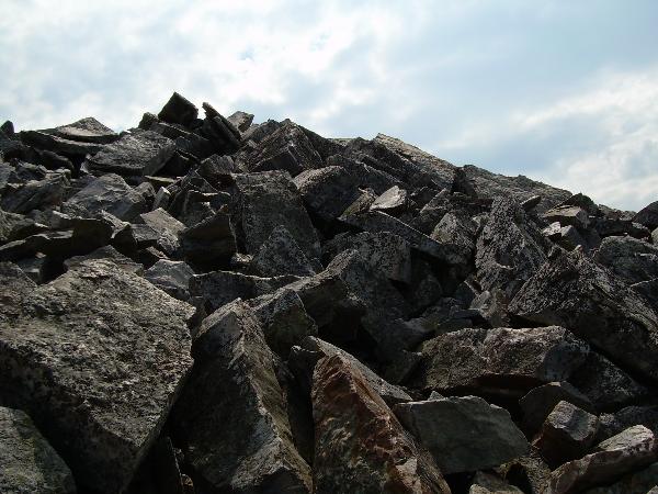
Mountains and beaches alike are popular vacation destinations. Each have something different to offer in the realm of beauty, recreation, relaxation, and enjoyment. Your imagination can take you from beach to mountain here at Blackrock. Close your eyes and imagine this place being an ancient beach! Approximately 500 million years ago the rocks around you would have been fine grains of beach sands in a tropical climate zone! Over the years, the sand sediment compacted into a sedimentary rock and was later metamorphosed into this tough erosion-resistant Hampton Quartzite that makes up Blackrock today. As the earth’s plates converged, this rock was pushed upwards. Try and imagine this large heap of rocks as one giant rock. For millions of years, it has been exposed to the elements.
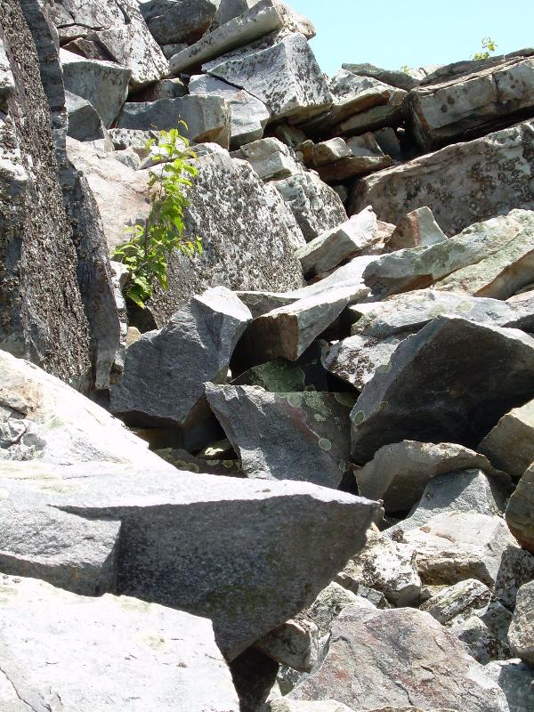
Look around and notice the cracks in the rocks. Now, in your mind’s eye, transport yourself to another era where the climate was vastly different. Approximately 18,000 years ago, this region would have been experiencing an ice age. Shenandoah National Park was not actually part of the area covered by glaciers. However, it was within 200 miles of this massive ice sheet. The climate was much colder and harsher than it is today. Imagine water seeping into the cracks and crevices in the rocks and freezing. This freezing process resulted in larger, more prominent breaks in the rocks. As you investigate the mound of rocks take notice of these cracks. What other forces, such as vegetation, currently cause rocks to break apart?
The rate of weathering of these rocks has slowed. How can you tell these rocks have remained in place for many years? How can you tell that something in your attic hasn’t been moved in a long time? It has a layer of dust on it! These rocks do not acquire “dust," but an actual living organism called lichens. There are 90 plus different species of lichens in Shenandoah National Park! At Blackrock you will notice a pale green lichen species that tends to form in a circular pattern. Another type of lichen, called Rock Tripe, has a grayish, brown-black color and leafy form. Blackrock is named for this latter lichen species due to its color. Research conducted between 2006-2008 provided knowledge of a rare lichen species located at Blackrock. This lichen had previously been noted only in Siberia and Northern Canada! This discovery provides a rare and interesting look into the past ice age climate and allows us to make real connections between the climate of long ago and today's climate. Enjoy the view as you circle the rock base!
ASSIGNMENT: Make a weather comparison. Can you equate your visit more with the tropical beach climate of 500 million years ago, the ice age of 18,000 years ago, or somewhere in between? What changes have occurred over the years that make up the current landscape? How is the current setting different from an ancient beach? Do you see any vegetation growing that could be an example of weathering? Can you find evidence of the ice age that weathered these rocks?
Waypoint #3: N38 13.219 W078 44.518 After exploring the semi-circle trail along the base of Blackrock, return to Waypoint #2. You will notice a trailhead for the Blackrock Spur Trail. Coordinates for the Spur Trail are N38 13.202 W078 44.433. This trail is only .2 mile long. As you begin your descent down the spur trail, you will follow the blue blazes and re-enter the woods. The Spur Trail connects with the Trayfoot Mountain Trail at N38 13.337 W078 44.543. Turn left. This vantage point will allow you the opportunity to see a spectacular display of crumbled rocks from the bottom.
 </center> <p align=" /> Waypoint #3 gives you a chance to realize the full beauty and magnitude of this grand talus slope (an accumulation of rocks at the base of a cliff) known as Blackrock. At Waypoint #3, the slope in front of you is considered active. How can you tell? While there are some trees and shrubs growing out of the rocks, vegetation is minimal. If this slope was inactive, you would see more evidence of the forest closing in around the rocks. This area is not as heavily traveled as the upper slopes. Look around for the Rock Tripe that Blackrock is named for. Under normal circumstances these rocks stay in place with only occasional shifting. However, from time to time, these rocks do roll! Everything that is active or in motion is headed somewhere. As you look up the mountain, think for a moment where these rocks are going. Over time, as they continue to roll downhill, they will eventually end up in the Shenandoah River which will carry them to the Chesapeake Bay and finally into the ocean. They will be weathered along the way, during the process of erosion, and will eventually end up as new beach sand thus starting the rock cycle anew! By human standards, you, no doubt, are planning to stay for a short time in Shenandoah National Park before venturing elsewhere. By geologic standards, these rocks are also essentially “visiting” Shenandoah for a “short” time as well on their journey to other places!
Upon completion, at this point, you may either re-trace your steps or continue along the Trayfoot Mountain Trail (.1 mile) until it meets the Blackrock Fire Road at which point you would turn left. Re-tracing your steps will give you a second look at the spectacular rock mound. If you choose to take the fire road, you can make a short detour by turning left, at the cement marker for the summit, to catch another glimpse of Blackrock!
ASSIGNMENT: What would have recently happened to rocks with no Rock Tripe on them?
References:
*Badger, Robert, 2004, Geology Along Skyline Drive, Shenandoah National Park, VA,pg 36-38
*Amberson, Joanne, 2004, Short Hikes in Shenandoah National Park, pg 23, www.snpbooks.org
*Appalachian Trail Website: http://www.nps.gov/appa/