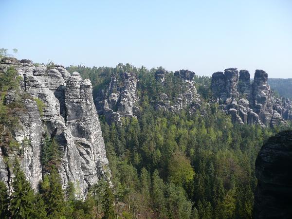
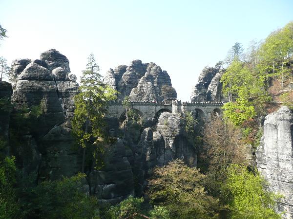
Die Bastei (305m ü. NN) ist eine Felsformation mit Aussichtsplattfort in der Sächsischen Schweiz am rechten Ufer der Elbe. Sie zählt zu den meistbesuchten Touristenattaktionen der Sächsischen Schweiz.
Von der Bastei fällt das schmale Felsriff über 194 Meter steil zu Elbe ab.
Sie bietet eine weite Aussicht über das Elbsandsteingebirge.
Schon der Name Bastei zeigt die frühe Einbindung der steil aufragenden Felsen in den Verteidigungsring der Felsenburg Neurathen.
The Bastei (305m ü. NN) is a rock formation with prospect flat away in Saxonian Switzerland on the right bank the Elbe. It ranks among the usually-visited Touristenattaktionen of Saxonian Switzerland. Of the Bastei drops the narrow rock reef over 194 meterssteeply to Elbe.
It offers a far prospect over the Elbsandsteingebirge.
Already the name Bastei shows the early integration of the steeply rising rock into the defense ring of the rock castle Neurathen.
Entstehung:
Die geologische Entstehung des Elbsandsteingebirges reicht zurück in die Kreidezeit. Vor etwa 180 Millionen Jahren begann derVorstoß des Kreidemeeres.
Die eigentliche Sedimentation begann mit den Niederschönaer Schichten, welche in unregelmäßig fließenden Gewässern abgelagert werden.
Darüber liegen teilweise erheblicher Mächtigkeit von bis zu 600m die marinen Bildungen des Kreisemeeres, welches im oberen Cenoman vor etwa 90 Millionen Jahren in die sich senkende Elbtalzone eindrang.
The geological emergence of the Elbsandsteingebirges is enough back into the chalk time. Approximately 180 million years ago the raid of the chalk sea began.
Actual sedimentation began with the Niederschönaer layers, which are deposited in irregularly flowing waters.
Over it partial are appropriate for substantial power of up to 600m the marine education of the circle sea, which penetrated in theupper Cenoman before approximately 90 million years into the lowering Elbtalzone.
Klima:
Das Klima des Elbsandsteingebirges ist infolge seiner geographischen Lage, sowie der geringen Höhenlage als
xollin bis submontan zu bezeichnen. Während große Teile des Gebietes in einer Höhenlage von 200-400m eine durchschnittliche Jahrestemperatur von 7°C - 8°C und Jahresniederschläge von 700mm aufweisen sind höher und östlicher gelegene Bereiche deutlich kühler und Niederschlagsfreie.
Hier fallen die Jahresmittelwerte der Temperatur auf etwas unter 7°C und die Niederschläge auf 900mm.
The climate of the Elbsandsteingebirges is due to its geographical location, as well as the small altitude as to designate xollin to submontan.
During large parts of the area in an altitude of 200-400m an average yearly temperature of 7°C - 8°C and yearly precipitation of 700mm.
exhibit are ranges lain more highly and more east clearly coolly and dry here fall the annual average values of the temperatureon somewhat under 7°C and the precipitation.
Um diesen Cache zu loggen, erfülle folgende Aufgaben:
1. Nenne mir eine der Sedimentschichten.
2. Nenne mir eine typische Verwitterungsform des Sandsteins in der sächsischen Schweiz.
3. Mache ein Foto von dir und deinem GPS (freiwillig) auf der Basteibrücke mit dem Gansfelsen im Hintergrund, welches du deinem log anhängst
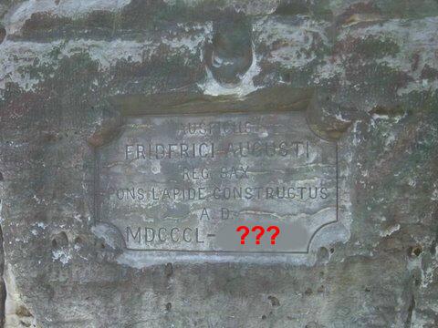
4. Am Ende der Basteibrücke findest du eine Steintafel. Welche Inschrift fehlt hier?
sende deine Antworten mit deinem Cachernamen an: ......@arcor.de - die Punkte sind durch das Lösungswort der vierten Antwort zu ersetzen,
oder schreibe mich über mein Profil an.
Sollte bei Deinen Antworten etwas nicht in Ordnung sein werde ich mich bei Dir melden.
.
In order to log this cache, fulfill the following tasks:
1. Tell me one of the sediment layers.
2. Tell me a typical decomposition form of the sandstone in Saxonian Switzerland.
3. Make a photo of you and your GPS (voluntarily) on the Basteibridge with goose rock in the background, which you attach your log
4. At the end of the Basteibridge you find a stone board.
Which inscription is missing here? send your answers with your Cachername on: ...... @arcor.de , or write your answers over my profile to me
.