From the guidelines, as from January 2013: "People do not need to wait for permission to log your EarthCache. Requiring someone to wait is not supported by the EarthCache guidelines. People should send their logging task answers to you, then log your EarthCache. When you review their logging task answers, if there is a problem, you should contact them to resolve it. If there is no problem, then their log simply stands."

Granite
Granite is a common and widely occurring type of intrusive, felsic, igneous rock. Granite has a medium to coarse texture, occasionally with some individual crystals larger than the matrix forming a rock known as porphyry. Granites can be pink to dark gray or even black, depending on their chemistry and mineralogy.
For more information on granites see this EarthCache: Granite - DP/EC26.
Granite landscapes
Most granite landforms are due to the exploitation of weaknesses, especially fractures, by meteoric waters, and particularly groundwaters. Moisture attack produces grus (see later), which commonly forms the bulk of the regolith in granitic terrains. The transition from weathered to fresh rock is typically abrupt, and takes the form of a narrow transition zone called the weathering front.
The regolith is physically weaker than the fresh rock, and is more readily eroded. It has over wide areas been stripped to expose the weathering front in etch surfaces: plains and platforms where the front was sensibly even, inselbergs, boulders, basins and gutters etc., where it was irregular. Etch forms evolve in two stages (initiation by subsurface weathering and then exposure) and they may be polygenetic in that the environments of weathering and exposure may be different. They also have two ages (weathering and exposure).
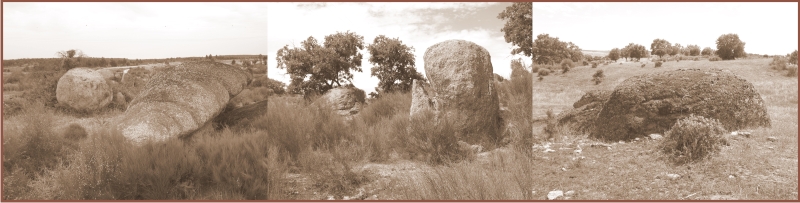
Granite landscapes are usually upland due to the upthrust of intrusion during the formation of the granite itself and the resistance of the rock to erosion. These landscapes present us with weird and wonderful forms of rock shapes due to specific weathering mechanisms. One such weird and wonderful form of granites is Pedestal rocks or Mushroom rocks. As the name implies these are normally pillars of granite with thin bases and flared tops creating the shape of a typical mushroom.
Let’s take a more detailed look so we can learn a bit more about granite erosion.
Granite weathering
Water is the key to granite weathering. Water penetrates into the rock mass mainly by way of open fractures. In this way the rock near the surface is rotted.
This weathered zone is known generally as the regoIith. It varies in thickness between nothing and several hundreds of metres. The plane or very narrow zone separating the regolith from the intrinsically fresh bedrock is the weathering front. It is the lower and lateral limit of significant weathering. Its morphology reflects weaknesses of any kind in the bedrock. Both in detail and in gross the front is irregular, though, as there is a tendency for any projections to be preferentially attacked and reduced simply because of the greater surface area of such protuberances exposed to weathering, some weathering fronts are remarkably smooth. The stripping of the regolith exposes the weathering front as an etch surface.
“To etch” is to corrode by means of an acid or other aggressive fluid. Groundwaters charged with acids, salts and bacteria are aggressive and convert the cohesive bedrock into a friable regolith, which can be regarded as a festering mass that is eating into the bedrock wherever the two are in contact, along the entire length of the weathering front.
Open fractures are avenues along which water penetrates. Fresh granite has a porosity of less than one per cent (it is commonly of the order of 0.1 per cent)
and a correspondingly low permeability. Water passing along fractures rapidly alters the rock with which it comes into contact. The weathering front migrates from the fracture planes into the blocks so defined, converting angular blocks into rounded masses. Solution, hydration, hydrolysis and oxidation are the main processes responsible for the disintegration and rotting of the rock though bacteria may well facilitate water penetration at the crystal scale.
Field observations suggest that the rock first breaks down physically into slivers or laminae. Further water attack causes alteration, the biotite being converted to hydrobiotite, vermiculite and various clays; the reactions are accompanied by the release of iron oxides. Feldspars are also altered to clay, usually kaolinite. The quartz is etched but persists much longer than either the feldspar or mica. The first product of granite decomposition is a gritty mass of quartz (and in places phenocrysts of feldspar) with small amounts of clay. It is known as grus. With further weathering this is changed to a mass of puggy clay with quartz fragments. Iron oxides and silica are also mobilised and are concentrated at or
near the base of the regolith at the weathering front where the iron concentration, for instance, may be 2-3 times that of the fresh rock. The weathered granite differs markedly from the original fresh rock not only in its mineralogy and chemistry but also in its physical characteristics. In particular its permeability increases dramatically, the capacity of weathered granite to transmit water being up to 60 times that of the fresh rock.

Getting back to the granite mushrooms
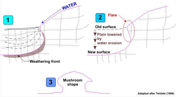
These features have erroneously been associated with wind erosion but there is compelling evidence supporting that the basic form was initiated below ground and at the weathering front. The accumulation of moisture either deep in the regolith close to the bases of projections of fresh rock (incipient inselbergs, pinnacles) causes especially intense weathering (#1). In massive rocks the weathering front is concave. After erosion of the scarp foot zone, flared slopes and enclosed depressions are exposed (#2). Long continued subsurface rotting of boulders leads to the formation of mushroom-shaped rocks (#3).
The Nisa-Albuquerque Batolith
The Nisa-Albuquerque batholith forms part of the regional Nisa-Los Pedroches NW–SE magmatic alignment, located in the southernmost sector of the Central Iberian Zone. It is a composite, elongate body exposed over an area of 1000 km2 in central Portugal and Spain, oriented parallel to, and crossing, the southern boundary of the Central Iberian Zone. In the north, the batholith intruded metasediments of the Schist–Greywacke complex (Neoproterozoic–Cambrian) and produced a contact metamorphic aureole 800–1200 m wide Portugal) the granitoids, which have an arcuate shape, intruded Ordovician granitoids and Ossa-Morena Zone rocks including the Coimbra–Córdoba shear zone. A late-stage fracture system affected the batholith, producing several N–S faults. Intra-batholithic and peri-batholithic tungsten, phosphorous and mainly uranium mineralization is associated with the batholith.
The Nisa-Albuquerque batholith consists of a dominant peraluminous coarse-grained porphyritic, two-mica monzogranite to syenogranite (S-type affinity) that occupies over 85% of the outcrop area and shows a marked differentiation from west to east. However the petrologic processes responsible for this zonation remain poorly understood.
This batholith has been extensively dated by both Portuguese and Spanish researchers. Ages for this batholith vary between 309 and 287 Ma.
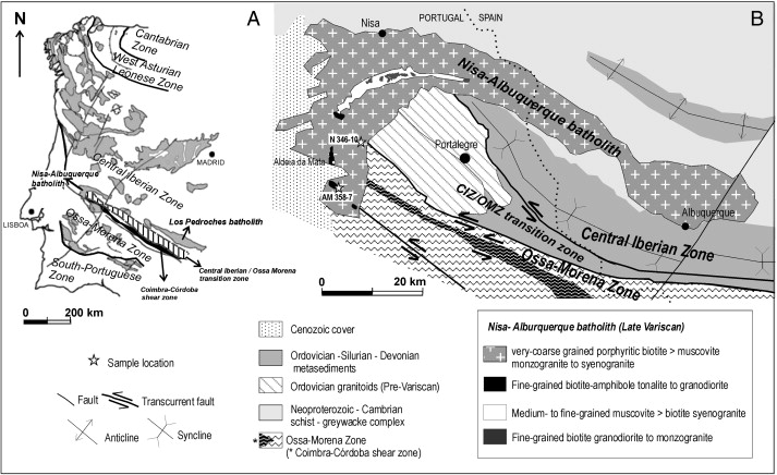
A- Sketch of the distribution of Variscan granite batholiths in Iberia and geological setting of area B- located at the boundary between the Central Iberian and Ossa-Morena Zones. B. Simplified geological map of the Nisa-Albuquerque batholith and its host rocks (After Solá et al., 2009).
The EarthCache
This EarthCache explores one of these pedestal or mushroom-shaped rocks within the Nisa-Albuquerque  batholith.
In order to claim this EC go to the coordinates and tell me:
- How high is the mushroom in front of you?
- How wide is the cap of the mushroom in front of you?
- Is the cap flat or curved? (from the observation point coordinates supplied)
Note:
1- NO pictures of the feature in question in any of the logs. Inclusion of spoilers will result in log deletion.
2- Observation point coordinates are supplied in case there is livestock in the paddock.
E-mail the answers through my profile to validate your find.
Note: Platinum EarthCache level "ribbon" courtesy of Play mobil.
References:
Campbell, EM, 1997. Granite landforms. Journal of the Royal Society of Western Australia, 80, p.101-112.
Solá, AR, Williams, AS, Neiva, AMR and Ribeiro, ML, 2009. U–Th–Pb SHRIMP ages and oxygen isotope composition of zircon from two contrasting late Variscan granitoids, Nisa-Albuquerque batholith, SW Iberian Massif: Petrologic and regional implications. Lithos (in print).
Twidale, CR, 1986. Granite landform evolution: Factors and implications. Geologische Rundschau 75/3, p.769-779.
Twidale, CR and Vidal Romani, JR, 2005. Landforms and Geology of Granite Terrains. Taylor and Francis, 351p.

Blocos Pedunculados de granito
Algumas rochas, como os granitos, quando sujeitas à acção dos agentes de meteorização adquirem formas particulares. Os blocos pedunculados são mais finos na base do que no topo, fazendo lembrar cogumelos ou chapéus de chuva gigantes.
Se fizerem uma busca na net sobre este tema podem vir a descobrir textos como este:
"Forma rochosa resultante da erosão diferencial provocada pelo vento. Em virtude da sua energia cinética, o vento provoca a deflação, isto é, desnuda as rochas, retirando-lhes os detritos mais pequenos e transportando-os. Como a carga, quantidade de detritos por unidade de volume, transportada pelo vento é maior junto ao solo, ocorre nas rochas uma corrosão diferencial que pode originar blocos pedunculados."
Está provado que o vento não é a acção que forma estes cogumelos rochosos. São formados pela acção de erosão devido à formação de uma frente de erosão côncava tal como indicada nos esquemas em cima.
A EarthCache
Notem bem que este cogumelo granítico encontra-se dentro de uma vedação ao qual se pode aceder facilmente saltando a cerca junto às coordenadas do ponto de observação. No entanto as perguntas podem ser todas respondidas a partir deste ponto.
Não coloquem fotos do cogumelo em questão nos vossos logs porque serão apagados.
Para se abilitarem a mais um found, respondam às seguintes perguntas:
1- Qual a altura do cogumelo? (estimem mas aviso-vos já que é inferior a 12 metros).
2- Qual a largura do "chapéu do cogumelo"?
3- O chapéu é plano ou curvo quando observado do ponto de observação?
Enviem-me as respostas via o meu profile para validarem o found.

 The most exciting way to learn about the Earth and its processes is to get into the outdoors and experience it first-hand. Visiting an Earthcache is a great outdoor activity the whole family can enjoy. An Earthcache is a special place that people can visit to learn about a unique geoscience feature or aspect of our Earth. Earthcaches include a set of educational notes and the details about where to find the location (latitude and longitude). Visitors to Earthcaches can see how our planet has been shaped by geological processes, how we manage the resources and how scientists gather evidence to learn about the Earth. To find out more click HERE.