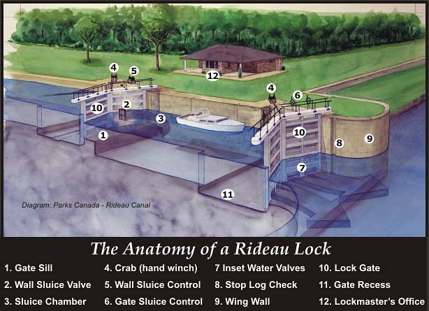
The Rideau Canal is the oldest continuously operated canal in North America. The locks work today much as they did when first opened in 1832. Back then, the Rideau was a wilderness of lakes, rivers and swamps. In the middle of this wilderness, with many men dying from malaria, an engineering marvel was created, the Rideau Canal.

The Rideau Canal is a chain of beautiful lakes, rivers and canal cuts. Winding its way through varying landscapes, it stretches a distance of 202 km from Kingston, at the head of Lake Ontario, to Ottawa, Canada's capital city.
Geological Formation
Thirteen thousand years ago, a blink of the eye in geologic time, the Rideau region was sitting under a glacier, over a kilometre in thickness. There were no lakes, no trees, no wildlife, and no people. As the glaciers receded they exposed the bedrock, striated (ice gouged) in many places, and they also left behind trillions of tons of glacial rubble. The bedrock, which had been depressed by the weight of the ice, now started to rise up (isostatic rebound). Vegetation started to take hold and eventually the region took on the appearance it has today.
Geology has played an important role in affecting the appearance of the area and influencing man's uses of the region. The shape of some of the lakes is tectonically influenced, an example being the Rideau Lakes (Big, Upper and Lower) which follow the trace of the aptly named Rideau Lake Fault. Fishing in the region is excellent since the lakes are unaffected by so called "acid rain", due to the fact that most of the lake basins are composed of limestone, which acts as a buffer to any acidic precipitation. Areas where the glaciers left thicker cover (gravels and soils) are now primarily agricultural regions, areas that have thin cover and exposed bedrock are generally wooded with little agricultural development.
The Rocks
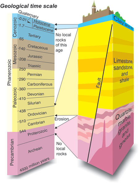
There is a basic division in the geological time scale that occurs at 600 million years ago. Everything prior to that date is known as the Precambrian. Most of the currently known fossil record of the earth comes after that, and there are many geological divisions from 600 million years ago to the present. Many of the rocks in the Rideau Region belong to the Precambrian.
Most of the Rideau Lakes region consists of Precambrian limestone (marble), gneiss, quartzite, granulite, migmatite and granitic (quartz monzonite) plutons. These rocks are overlain in many parts by more recent, Palaeozoic sedimentary rocks. There is not a great deal of relief in the area, but much of what can be seen is a result of differential erosion. Softer rocks, such as the limestone, are eroded more quickly, and now form the basins of many of the lakes. Harder rocks such as the gneisses, quartzites, and granites tend to form many of the hills and ridges in the region.
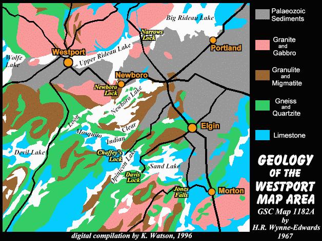
In a regional sense, the Precambrian rocks in the Rideau region form part of what is known as the "Frontenac Axis", a narrow section of the Canadian Shield that links the Laurentian Plateau with the Adirondack Mountains of New York. >
Most of the Precambrian rocks have been metamorphosed (altered from their original state by pressure and heat) and belong to the Grenville Metamorphic Series. They are in excess of one billion years old. These metamorphic rocks were intruded by younger igneous rocks (granites and gabbros). These in turn were cut by more recent intrusive rocks, pegmatites and diabase dykes.
These Precambrian rocks are separated by a long erosional period in contact with overlying Palaeozoic sedimentary rocks. These include sandstone, conglomerate, dolomite, dolomitic limestone, sandy shale, fine grained grey limestone, and sandy limestone. It is from this series of rocks that the blocks for the Rideau locks and dams were cut.
The Glaciers
Notwithstanding the arguments over man's role in global warming, it exists, and has existed in the Rideau region for the last 13,000 years. There have been four periods of glaciation in recent times, each lasting about 100,000 years, and each separated by an interglacial period with temperatures as warm or warmer than they are now. At the height of each glacial period, over 30% of the earth's surface was covered by ice (compared to 10% ice coverage today).
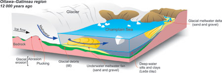
The most recent period of glaciation in North America is known as the Wisconsin Period. In the Rideau area, it first took hold about 90,000 years ago, and ended about 13,000 years ago. As the ice retreated, the landscape underwent progressive changes.
Thirteen thousand (13,000) years ago, the whole region, including present day Lake Ontario was under ice.
Twelve thousand, five hundred (12,500) years ago, Lake Iroquois had formed where present day Lake Ontario is located. It was quite a bit bigger than Lake Ontario, and considerably higher (about 335 feet above sea level compared to today's 243 feet), since the water outlet to the east was blocked by the retreating glaciers. Lake Iroquois drained southeast into present day New York State.
Twelve thousand (12,000) years ago, Lake Iroquois covered most of the Rideau region, stretching all the way north to Ottawa.
By eleven thousand, five hundred (11,500) years ago, the scene had changed quite dramatically. The glaciers had retreated far enough to open up the St. Lawrence Valley lowland and let the ocean flood in. The Champlain Sea extended west, all the way up the Ottawa River Valley, past Ottawa. The southwestern margin of this sea was close to the present day height of land that traverses the Lower Rideau Lake area. At this time, the drainage from Lake Iroquois/Lake Ontario was east, down the channel of the present day St. Lawrence River, into the Champlain Sea. This new drainage resulted in a lake that was a bit smaller than present-day Lake Ontario.
Some of the answers required to log this cache will be found on interpretive panels next to canal at the posted coordinates. For the other answers, more research will be required.
The above information was written and published by Mr. Ken Watson. I contacted Mr. Watson and received approval to use his material in relation to this Earthcache.
To log this Earthcache, you must:
1. Take a photo of yourself along with your GPS at the posted coordinates with the locks as well as the Ottawa River in the background (No longer mandatory).
Also:
Email through my profile, the answers to the following questions, do not post them on the cache page:
2. Estimate the distance from the start of the first (1st) lock next to the Ottawa River to the last (8th) lock
3.What is the name of the oldest building in Ottawa and the first permanent structure built on the Rideau Canal?
4. Identify two members of the Military and Civilian engineering staff who worked in the Ordnance and Engineering building and indicate the positions they held
5. This magnificent flight of locks has a lift of how many meters.
6. Name the valley that was chosen as the site for a set of locks to link the Ottawa and Rideau Rivers.
7. The Rideau Canal was recognized as the best preserved example of what type of canal.
8. Why did the cut between Rideau and Newboro lakes proved to be one of the most difficult tasks undertaken on the canal?
9. Bonus Question: How many kilometres of the Rideau Canal were dug by hand?
In 1925, the Rideau Canal was designated as a National Historic Site of Canada and in 2007, it was inscribed as a UNESCO World Heritage Site.