Moore erwartet man eigentlich
in der norddeutschen Tiefebene oder im fernen Skandinavien - aber
nicht in einer Mittelgebirgslandschaft, wie sie der Naturpark
Solling-Vogler beherbergt. Während der letzten Eiszeit bildete sich
aus der Umlagerung verwitterten Sandsteins, der mit Löss vermengt
wurde, wasserundurchlässiger Boden. Vor etwa 4500 Jahren bildeten
Torfmoose kleine Hügel, die dann allmählich zusammenwuchsen. Im
Zentrum entstand so eine fünf Meter mächtige Torfschicht.
Ursprünglich gab es im Solling rund 1200 Hektar Waldmoore.
 Diese Areale wurden jedoch in den vergangenen Jahrhunderten
nach und nach entwässert, unter anderem auch durch den Bau von
Flößteichen. Der Transport großer Holzmengen bereitete den Menschen
bis ins 18. Jahrhundert viele Schwierigkeiten. Einfacher als mit
Pferdewagen war der Transport mit der Flößerei. Um jährlich 4000
Klafter Buchen-Brennholz über die Ilme und Leine in die Residenz
Hannover zu transportieren , wurde 1737 der Neue Teich als
Flößteich künstlich angelegt. Nach Öffnung der Teichschotten wurde
das Holz auf einer Wasserwelle talwärts getragen. Spätestens mit
dem Bau des Teiches wurde das Moor teilweise entwässert. Die
niedersächsischen Landesforsten haben im Solling die Renaturierung
mehrerer Waldmoorgebiete fortgesetzt. Im Bereich des Forstamtes
Winnefeld werden frühere Moore wieder vernässt. Dazu wurden die
ehemaligen Entwässerungsgräben abgedichtet teilweise Fichten und
Birken entfernt. Der Wasserpegel sei inzwischen in allen
betroffenen Bereichen deutlich gestiegen. Sogar erste Moorpflanzen
hätten sich schon angesiedelt. Bis sich dort die für Waldmoore
typischen Pflanzengesellschaften entwickeln, werde es aber wohl
mehrere Jahrzehnte dauern.
Diese Areale wurden jedoch in den vergangenen Jahrhunderten
nach und nach entwässert, unter anderem auch durch den Bau von
Flößteichen. Der Transport großer Holzmengen bereitete den Menschen
bis ins 18. Jahrhundert viele Schwierigkeiten. Einfacher als mit
Pferdewagen war der Transport mit der Flößerei. Um jährlich 4000
Klafter Buchen-Brennholz über die Ilme und Leine in die Residenz
Hannover zu transportieren , wurde 1737 der Neue Teich als
Flößteich künstlich angelegt. Nach Öffnung der Teichschotten wurde
das Holz auf einer Wasserwelle talwärts getragen. Spätestens mit
dem Bau des Teiches wurde das Moor teilweise entwässert. Die
niedersächsischen Landesforsten haben im Solling die Renaturierung
mehrerer Waldmoorgebiete fortgesetzt. Im Bereich des Forstamtes
Winnefeld werden frühere Moore wieder vernässt. Dazu wurden die
ehemaligen Entwässerungsgräben abgedichtet teilweise Fichten und
Birken entfernt. Der Wasserpegel sei inzwischen in allen
betroffenen Bereichen deutlich gestiegen. Sogar erste Moorpflanzen
hätten sich schon angesiedelt. Bis sich dort die für Waldmoore
typischen Pflanzengesellschaften entwickeln, werde es aber wohl
mehrere Jahrzehnte dauern.
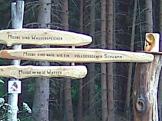
Nun zu den Logbedingungen:
Wir hätten gern ein
Foto von Euch unter dem Zugangsschild „Moorerlebnis
pur“ und die Antworten auf die folgenden Fragen:
Frage 1: Was haben die Untersuchungen der bis zu 1,8 m tiefen Torfe
gezeigt?
Frage 2: Was führte an dieser Stelle zur endgültigen Vertrocknung
der Moore vor über 40 Jahren?
Der Log darf mit
der Zusendung der Antwort an uns erfolgen. Sollte etwas falsch
beantwortet sein, melden wir uns.
One expects moors,
actually, in the North German lowland or in distant Scandinavia -
but not in a middle mountainous region how it accommodates in the
nature park Solling Vogler in Lower Saxony. The highmoor is the
largest moorland in the mountain country of Lower Saxony outside of
the Harz National Park. During the last ice age water-and-permeable
soil formed from the relocation of sandstone weathered, which was
blended with Loess. Before approximately 4500 years Peatmoss formed
small hills, which grew together then gradually. In the center so a
five meters powerful peat layer developed. Originally there were in
the Solling about 1200 hectares of forest moors. Nevertheless,
these areas were drained during the past centuries bit by bit,
among the rest, also by the construction of little raft ponds. The
transport of big wooden amounts caused many difficulties to the
people till the 18th century. Easier than with horse carriage was
the transport with the rafting of timber. To transport yearly 4000
fathom beech firewood about the “Ilme” and
“Leine” in the residence Hannover, the “Neue
Teich” was put on in 1737 as a rafts pond artificially. After
opening of the pond scots the wood on a water wave downwards was
carried. At the latest with the construction of the pond the moor
was partially drained. The land forests from Lower Saxony have
continued the renaturation of several forest moor areas in the
“Solling”. In the area of the forestry office Winnefeld
former moors become again recultivated. In addition the former
drainage channels were removed sealed partial spruces and birches.
The water level recorder has clearly risen, in the meantime, in all
concerned areas. The even first moor plants would have already
settled. Until there the plant societies typical for forest moors
develop, however, it will probably last several decades. You will
find closer information locally.
Now to the logging
requirements:
We would like a
photo of you taken under the access sign „Moorerlebnis
pur“ and the answers to the following questions:
Question 1: What
have the investigations of the up to 1,8-m-deep peat shown?
Question 2: What led at this point to the final drought of the
moors 40 years ago?
