Rundweg Monstein - Rüggsitenwald Multi-cache
Rundweg Monstein - Rüggsitenwald
-
Difficulty:
-

-
Terrain:
-

Size:  (regular)
Related Web Page
Please note Use of geocaching.com services is subject to the terms and conditions
in our disclaimer.
--- English see below ---
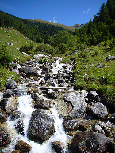
Dieser Multicache führt durch das Dorf Davos Monstein (Walsersiedlung auf 1626 m.ü.M.) und weiter durch alpine Bergwälder, vorbei an Wiesen, Alpen und rauschenden Bergbächen zurück zum Ausgangspunkt (Rundweg). An vielen Orten ist eine schöne Aussicht garantiert.
An den angegebenen Kooridnation befindet sich nicht der Cache, sondern der Ausgangspunkt zur Wanderung. Bitte parkiert das Fahrzeug am angegebenen Parkplatz am Anfang des Dorfes Davos Monstein (siehe Waypoint). Für die gesamte Wanderung (ohne Pausen) benötigt man etwa 2 Stunden. Es ist auch möglich den Cache mit dem Mountainbike zu suchen.
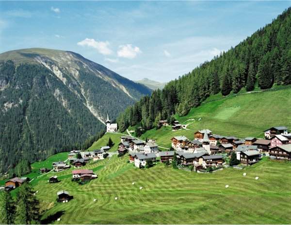
Davos Monstein
Geht zuerst immer der grössten Strasse nach durch das Dorf bis zur Bierbrauerei.
Aufgabe 1:
Auf der gegenüberliegenden Strassenseite der Bierbrauerei findest oberhalb einer Tür einige gezeichnete Murmeltiere. Anzahl Murmeltiere mit 4 multiplizieren = A B
Bleibt auf dieser Strasse und geht bis am Ende des Dorfes. Dort steht ein Wegweiser. Man nimmt nun den Wanderweg Richtung Laubenenalp. Der Weg geht leicht aufwärts bis zur Alp, die im Sommer bewohnt ist und welche man etwa nach 30 Minuten Marschzeit erreicht.
Aufgabe 2:
Sucht den ersten gelben Wegweiser auf der Laubenenalp. Auf der Rückseite der Wegweiser ist eine Zahl notiert = C D E F / G H I
Nun kann man die Koordinaten des Endcache ausrechnen:
U = G - A
V = E + F
W = G
X = F + D
Y = B + H
Z = B + C + G - A
N 46° 42.UVW E 009° 46.XYZ
Man folgt nun dem schmaleren Weg aufwärts bis zum Cache. Man muss den Weg nicht verlassen bis wenige Meter vor dem Cache.
Nachdem man den Cache gefunden hat, kann man dem Pfad weiter folgen und erreicht in wenigen Minuten einige Alphütten. Von dort geht es in 35 Minuten zurück zum Ausgangspunkt.
Oberalpbach
---------------------
The way to the cache starts in the small and lovely village "Davos Monstein" (1626 m a.s.l.), goes further through alpin forrests and some idyllic alps. The path finally leads you back again to the village Davos Monstein. All in all, the complete tour takes about 2 hours hiking, rest periods not included.
Start your searching-trip at the brewery (in the middle of the village). Opposite the brewery is the house of the marmots.
First question:
Count how many marmots are there by the door and multiply it by 4 = A B
Then, follow the biggest street till you get to the end of the village. At the fork, continue your search along the path that leads you to the alp called "Laubenenalp" (takes about 30 minutes).
Second question:
Once arrived at the alp Laubenalp, look for the first yellow flip side. Behind this flip side, you will find a number = C D E F / G H I
Calculate the final coordinates:
U = G - A
V = E + F
W = G
X = F + D
Y = B + H
Z = B + C + G - A
Final Cache Coordinates: N 46° 42.UVW E 009° 46.XYZ
After the found, walk to the next alp (takes about 5 minutes) and then back to the village Davos Monstein (takes another 35 minutes).
Additional Hints
(Decrypt)
Nz Shff rvarf Sryfraf jravtr Zrgre boreunyo qrf Jrtrf / Arne n ovt ebpx, bayl 3 zrgref njnl gur cngu.