|
   |
|
|
| Map |
 |
| Budapest |
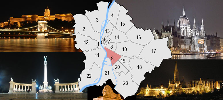
Budapest is a city of multiple characters, different geographical areas and of wide variety of architectural styles. The current city was established on 17th November, 1873 by the unification of the settlements of Pest, Buda and Óbuda on the banks of the Danube river. Budapest had 10 districts after coming into existence in 1873, numbered 1 to 10. In the 1930s, 4 new districts were organized, numbered 11 to 14. On 1st January, 1950, Budapest was united with 7 neighbouring towns and 16 villages, hence the number of its districts increased to 22. In 1994, one of the former villages left district 20 in order to form the 23rd district. Budapest's current 23 districts extend to an area of 525 square kilometres (202.7 sq mi). Most of the districts have a special flavour - from a posh downtown area one can get easily into the hilly districts of Buda or to the green suburbs of Pest. Several districts still bear the marks of the enforced industrialization of the 50s and 60s. City parks, forests of the Buda Hills, boat-houses along the Danube, flowery islands, shipyards and chemical plants, the Royal Castle and prefab housing estates are all part of this wonderful city.
The Great Budapest Geocaching Adventure guides you through all 23 districts with the goal of displaying the most typical or most unique sites in each of them. In each cache there is a code you need to uncover for the real coordinates of the bonus cache. You can find the codes on the inside of the lids of each cache container and in the logbooks. Happy caching. |
| 9th district |
| A small, garden settlement founded on the end of the 18. century in the today's Ráday and Lónyay on streets' neighbourhood, later it was totally destroyed in the flood of 1838. Only 19 were left of 529 houses. Following this they raise a dam on the coast, the lowest parts were charged and the houses were built out of a stone again. The large industrialisation was beginning in the end of the 19. century: the largest slaughterhouse, five mills settled here, warehouses has been builded on the coast, also the Main Market Hall. The quarter raised apart from the Budapest's towngates received his name of the occasion of I. Ferenc accession to the throne in 1792. In the union of Old Buda, Pest and Buda (1879) this part took the 9.-th number from Budapest’s districts, his then area was equal to the current one's. The inner Ferencváros the Kiskörút (Vámház krt.) and the Nagykörút (Ferenc körút) part is the oldest one, mostly townish area. The Middle-Ferencváros is the area between the Nagykörút and Haller út. Haller út, was the city border and the district’s flood protection line for a long time. (Ferencváros dam) The area along Soroksári út and Vágóhíd utca was the place of mills and other, industrial activities wich was connected to agriculture. The Outer-Ferencváros is the district's industrial area divides up into three parts. The surronundings of Soroksári street - Gubacsi street - Outer Mester street where agricultural processing-industrial, hard- and military industrial establishments can be found then. And here can be found the country's largest shunting yard. The József Attila Lakótelep also can be found in the district, this is one of the capital's oldest and friendliest building estate. |
 |
|
|
| The hiding place |
The Holy Cross Parishchurch
The religious life began in 1920 at the Outer-Ferencváros. Then was not any opportunity to establishing an independent parsonage, but the claim of the building of a constant chapel was a real plan. From the money collected by the parish and with the considerable contribution of the capital city the Holy Cross Church may have been built from 350.000 pengo (former currency of Hungary). On the corner site, wich is lying at the Ecseri út and Ülloi út crossroads the charter of the temple was placed with the occasion of the initation of the foundation stone in october of 1929. The new church with a floor-space of 573 m2 has been builted up in 1930 by the plans of Gáspár Fábián architect. The 2000 persons reception suitable building has been ordained in 1930. September by Serédi Jusztinián primatical in the celebration of the praising of the holy cross. The two bells of the church has been ordained in September 7.th of 1930. The communion has bought the lilac of an eliminated convent in 1950 for the church. The lilac has been built in 1930 at the Angster factory in Pécs. In 1994 in the left-wing tower bottom a colombárium (urnal burial place) was established. The church's full renovation is happened from 1996 until 2005. This years are the renovation of the roofing, the full cleaning of the exterior walls (1999-2000), change the lighting to a modern solution and the cleaning of the wall pictures of sanctuary. The church's floodlight came true also. The clock of the church has been built by József Konkoly master builder in 2001. The full renovation of the building and its modernisation were ready for 2005, in the 75. anniversary of the consecration. The church was being built in a neo-Roman style. The sanctuary ends with a semicircular apse. The nave rises above the side aisles. Two 40 metres tall tower surrounds the gable of the main entrance. On the head's and side aisles' 6-6 semicircular windows insure the illumination on the church's. The two-winged oak tree gates wrought-iron mountings decorate it.
For more please visit: http://www.szentkeresztplebania.hu/ |
| Approaching |
 You can use the Metro (line No.:3) from both end station to Ecseri út metro station or by tram from Kobánya-Kispest railway station (5 stops to Ecseri út) (visit link). You can use the Metro (line No.:3) from both end station to Ecseri út metro station or by tram from Kobánya-Kispest railway station (5 stops to Ecseri út) (visit link).
 You can use the official bikeroad to the destination (It goes thru the Népliget) (visit link) You can use the official bikeroad to the destination (It goes thru the Népliget) (visit link)
 You can park free at this coordinates: 47 28.284 / 19 06.491 see them at waypoints You can park free at this coordinates: 47 28.284 / 19 06.491 see them at waypoints
|
| Budapest |
| Budapest ist eine Stadt bunten Charakters, unterschiedlicher geographischer Zonen und einer breiten Vielfalt an architektonischen Stilen. Die heutige Stadt wurde am 17. November 1873 durch Zusammenschluss der Städte Pest, Buda und Óbuda, die an beiden Ufern der Doanu liegen, gegründet. Budapest hatte damals 10 Bezirke, nummeriert von 1 bis 10. In den 30er-Jahren kamen 4 weitere Bezirke (11-14) hinzu. Am 1.Jänner 1950 wurde das Stadtgebiet um angrenzende 7 Städte und 16 Dörfer erweitert, die Zahl der Bezirke erhöhte sich damit auf 22. 1994 wurde eines der früheren Dörfer aus dem 20. Bezirk ausgegliedert, womit ein neuer 23. Bezirk enstand. Die derzeit 23 Bezirke haben eine Ausdehnung von insgesamt etwa 525km² (202,7mi²). Die meisten dieser Bezirke haben ihren unverwechselbaren Charakter - von repräsentativen Innenstadtbereichen über die hügeligen Bezirke von Buda bis hin zu den erholsamen grünen Vorstädten von Pest ist alles zu finden. Einige Bezirke stehen bis heute im Zeichen der stark forcierten Industrialisierung der 50er- und 60er-Jahre. Stadtparks, die Wälder der Budaer Berge, Bootshäuser entlang der Donauufer, blütengezierte Inseln, Werften und Chemiebetriebe, die königliche Burg und auch Fertigteil Wohnhausanlagen sind alle Teil dieser wundervollen Stadt. Das Große Budapester Geocaching Abenteuer wird durch jeden der 23 Bezirke führen und versuchen, in jedem etwas Typisches oder Einzigartiges zu zeigen. Jedem, der alle 23 Caches besucht, winkt als Draufgabe ein BONUS-Cache. Happy Caching. |
| 9. Bezirk |
| In der zweiten Hälfte des 19ten Jahrhunderts fang eine große Industrialisierung im 9ten Bezirk an: niederließ sich hier der größte Schlachthof, 5 Mühlen, am Ufer wurden die Lager und am Jahrhundertwächsel die Große Markthalle aufgebaut. Der Bezirk hat seinen Namen nach der Inthronisation von Franz Josef Karl als Franz II. im Jahr 1792 bekommen. Die Haller Straße war die Grenze der Stadt und die Überschwemmungslinie (Franzstadtische Dämme). Das Gebiet neben der Soroksári Straße und der Vágóhíd Straße waren die Orten der Mühlen und andere agrarische Tätigkeiten gemischt mit Wohnhäuser. Auch in diesem Bezirk ist die Jozsef Attila Stadtsiedlung zu finden, die eine der altesten und freundlichste Wohnsiedlung der Stadt ist. |
|
| Das Versteck |
Saint-Kreuz Kirche
Im Außen-Franzstadt began das geistliche Leben im Sommer 1920. Die Saint-Kreuz Kirche konnte von den gesammelten Geld des Kirchengemeinde und mit der Zubuße der Haupstadt von 350 000 Pengö aufgebaut worden. Im Jahr 994 wurde im rechten Turm ein Colombarium entstanden. Von 1996 bis 2005 wurde die ganze Kirche renoviert: die Kirche hat die Festbeleuchtung bekommen und József Konkoly hat auch die seit 1930 gewartete Turmuhr fertiggestellt. Die Kirche wurde im neoromänischen Stil gebaut.
Webseite: http://www.szentkeresztplebania.hu/ |
| Verkehrsverbindung |
Mit untergrundbahn vom beide terminal zu Ecseri út oder mit Straßenbahn von Kobánya-Kispest bahnstation (5 anhalten zu Ecseri út) (visit link).
Es gibt Fahrradweg zum Ziel durch das Népliget (visit link)
Das freie parken auf den gewährten koordinaten (47 28.284 / 19 06.491)
|
| Budapest |
| Budapest ezerarcú város, melyet földrajzi változatossága és építészeti sokszínusége varázsol egyedivé. Az 1873. november 17-én Pest Buda és Óbuda egyesítésével létrejött akkori fovárosnak 10 kerülete volt, amely az elkövetkezo évtizedek során fokozatosan bovült a mai 23-ra. A város ma 525 négyzetkilométeren terül el. A különbözo kerületek a folyamatos fejlodés és átalakulás mellett továbborzik sajátosságaikat, a Belváros csillogó bevásárló utcái, Buda dombvidéke vagy a pesti zöldövezet lakónegyedei mind sajátos hangulattal bírnak. A város arcát továbbra is sebhelyként csúfítják az 50-es 60-as évek eroltetett iparosításának "emlékmuvei". Zöld parkok és ligetek, a Budai hegyvidék erdoi, Duna-parti csónakházak, virágos szigetek, hajógyárak és vegyi üzemek, a Budavári palota és panel lakótelepek - ez mind Budapest. A Nagy Budapesti Geocaching Kaland végigvezet mind a 23 kerületen bemutatva az adott városrész legjellegzetesebb vagy éppen a legfurcsább vonását Ha mind a 23 ládát megtalálod, indulhatsz a BONUS csésze megkeresésére. Kalandra fel! |
| 9. kerület |
| A 18. század végén alakult ki egy kertes település a mai Ráday és Lónyay utcák környékén, amely késobb az 1838-as árvízben teljesen elpusztult. 529 házból csak 19 maradt meg. Ezt követoen a parton gátat emeltek, a legalacsonyabban fekvo részeket feltöltötték és a házakat kobol építették újra. A 19. század második felében nagyarányú iparosítás kezdodött: ide települt a legnagyobb vágóhíd, öt malom létesült, és a parton felépültek a Közraktárak, illetve a századfordulón a Központi Vásárcsarnok. A Pest városkapuin kívül emelt városrész 1792-ben I. Ferenc trónra lépésének alkalmából kapta nevét. Az 1879-ben Pest, Buda és Óbuda egyesítésével kialakult Budapest kerületei közül, a IX-es sorszámot kapta az akkor már a mai kiterjedésével azonos városrész. A Belso-Ferencváros a Kiskörút (Vámház krt.) és a Nagykörút (Ferenc körút) közti rész a legrégibb, leginkább városias terület. A Középso-Ferencváros a Nagykörút és a Haller út közötti terület. A Haller út, amely sokáig a város határa, egyben árvízvédelmi vonala (Ferencvárosi védgát) is volt. A Soroksári út és a Vágóhíd utca menti terület a malmok és egyéb, mezogazdasággal kapcsolatos ipari tevékenységek területe volt, lakóházakkal keverten. A Külso Ferencváros a kerület ipari területe három részre tagolódik. A Soroksári út - Gubacsi út - Külso Mester utca menti területekre ahol mezogazdasági feldolgozó-ipari, nehéz- és hadiipari létesítmények voltak találhatóak. Valamint itt található a Külso Mester utcában az ország legnagyobb rendezo pályaudvara is. Szintén a kerületben található A József Attila Lakótelep ami a Fováros egyik legrégebbi és legbarátságosabb lakótelepe. |
|
|
| A rejtek |
Szent kereszt Plébániatemplom
Külso-Ferencvárosban 1920 nyarán indult meg az egyházi élet. Ekkor még nem volt lehetoség önálló plébánia alakulására, de már kezdettol fogva meg volt egy állandó kápolna építésének igénye. Az egyházközség által összegyujtött pénzbol és a Székesfováros jelentos hozzájárulásával, a költségek háromnegyed részének biztosításával 350.000 pengobol felépülhetett a Szent Kereszt templom. Az Ecseri út és az Ülloi út keresztezodésénél fekvo saroktelken 1929. október 13-án elhelyezték az alapító okiratot az alapkoletétele alkalmával. Dr. Fábián Gáspár muépítész által tervezett 573 m2 alapterületu új templom 1930-ban el is készült. A 2000 fo befogadására alkalmas épületet 1930. szeptember 14-én Serédi Jusztinián hercegprímás szentelte fel, a templom titulusának: a Szent Kereszt felmagasztalásának ünnepén. A templom két harangját 1930. szeptember 7-én szentelték fel. 1950-ben vette meg az egyházközség az államosításkor felszámolt Széchenyi-hegyi Isteni szeretet lányai zárda orgonáját a templom számára. Az orgonát 1930-ban a pécsi Angster Gyár készítette. 1994-ben a baloldali toronyaljban colombárium (urnás temetkezési hely) létesült. Az 1996-tól 2005-ig terjedo idoszak meghozta a templom teljes felújítását, rekonstrukcióját. A hatalmas munka kivitelezésének lehetoségét az Esztergomi Foegyházmegye, a IX. kerületi Ferencvárosi Önkormányzat összefogása, támogatása, valamint pályázati pénzek elnyerése és nem utolsó sorban a hívek adománya teremtette meg. Sor került a tetoszerkezet, a födém felújítására, 1999-2000 években a külso kofelületek teljes letisztítására, a korszeru világítás teljes rekonstrukciójára, valamint a szentély falképeinek tisztítására. Megvalósult a templom díszkivilágítása is. 2001-ben Konkoly József toronyóra építomester készítette el az 1930 óta várt toronyórát. Az épület teljes felújítása, korszerusítése 2005-re, a felszentelés 75. évfordulójára készült el. A templom neoromán stílusban épült, latinkereszt alaprajzú háromhajós templom a fohajóval azonos magasságú keresztházzal, a szentély két oldalához csatlakozó sekrestyével rendelkezik. A Szentély félköríves apszissal zárul. A fohajó a mellékhajók fölé magasodik. A fobejárat oromfalát két 40 méter magas gúla alakú toronysisakkal fedett homlokzati torony fogja közre. A templom hosszanti oldalain a fo- és mellékhajók 6-6 félköríves ablaka biztosítja a templom megvilágítását. A bejáratát két oszlop párra támaszkodó, timpanonos eloépítmény teszi látványossá. A kereszthajó baloldali homlokzatán hasonló, de szerényebb kivitelezésu oldalbejárat van. A kétszárnyú tölgyfa kapukat kovácsoltvas veretek díszítik. A tornyokat ikerablakok tagolják.
Weblap: http://www.szentkeresztplebania.hu/ |
| Megközelítés |
Használhatod a 3-as metrót mindkét végállomásától az Ecseri útig, vagy jöhetsz villamossal Kobánya-Kispest vasútállomástól (5 megálló - Ecseri út) (útvonalterv)
A célhoz eljuthatsz a Népligeten keresztül vezeto bicikliúton is! (térkép)
Ingyenes parkolási lehetoség ezeken a koordinátákon található: 47 28.284 / 19 06.491 Lásd útpontoknál. |