Schüsselstein EarthCache
-
Difficulty:
-

-
Terrain:
-

Size:  (other)
Please note Use of geocaching.com services is subject to the terms and conditions
in our disclaimer.
Ein Earthcache nördlich von Fischbach!!
An earthcache north of Fischbach!!
 Deutsche Version:
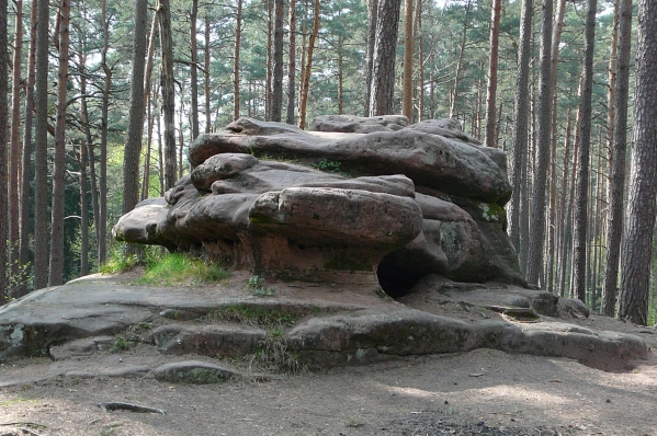
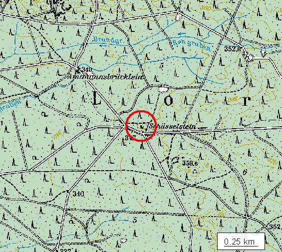
Der Schüsselstein ist ein großer Sandsteinmonolith, welcher sich nördlich von Fischbach befindet. Der Stein ist ein offiziell eingetragenes Geotop mit der Geotopnummer 574R005. Er liegt auf einer Höhe von 347 m in einer Sandsteinkeuperregion im Mittelfränkischen Becken. Die Ausmaße betragen 10m in der Länge und Breite und 5 m in der Höhe.
Der Name des Steins kommt von seinen schüsselförmigen Vertiefungen, die nach Regen fast immer mit Wasser gefüllt sind. Hält man beide Hände in je eine der Wasserschüsseln, so spürt man deutlich einen ganz unterschiedlichen Härtegrad des Wassers. Dem Stein und dem in den Schüsseln stehenden Wasser werden Heilwirkungen zugeschrieben. Auch hatten diese Felsen bei den Kelten eine kultische Bedeutung.
Um diesen Earthcache loggen zu dürfen, müssen zunächst die beiden folgenden Bedingungen erfüllt werden:
1. Begib dich auf die nördliche Seite des Steins. Dort siehst du 2 kleinere Höhlen. Die größere
von beiden wird durch wieviele „Säulen“ gestützt? (Zur Anmerkung, da es hier zu Problemen kommt: Eine Säule ist eine lotrechte, freistehende Stütze aus Holz, Stein, Ziegel oder Metall mit rundem Querschnitt) (E-mail an schuesselstein.[ZIFFER]@gmx.de - wäre die Ziffer 35, dann: schuesselstein.35@gmx.de - wenn die Antwort richtig ist, bekommst du sofort Bescheid und kannst loggen!)
2. Mache von dir ein Foto mit dem GPSr vor dem Stein!
 English Version:
The Schlüsselstein is a big monolith. It consists of sandstone and is an official geotop. The stone has an own geotop number, which is 574R005. Located north of Fischbach 347m above sea level in a sandstone Keuper region in the Middle-Franconian basin. The dimension are 10 m in the length and width and 5 m height.
The name of the stone is caused of its dish formed troughs, which are mostly filled with rainwater. If you hold both hands into two different water bowls, you notice explicit the different water hardness. Medicinal benefit is ascribed to the stone and the water of the bowls. As well this stone had Celtic denotation.
To log this earthcache you have to fulfil following two conditions:
1. Find at the north side of the stone two little caves. How many pillared can you see on the bigger cave? (please send an email to following adress schuesselstein.[DIGIT]@gmx.de - if the digit would be 35 then use the mail schuesselstein.35@gmx.de - if the answer is correct you will recieve automatically an approval mail)
2. Make a photo of you with your GPSr in front of the stone.
Viel Spaß beim Suchen und Erkunden wünscht

Additional Hints
(No hints available.)