Salem Lake, A Hydrologic Modification EarthCache
Salem Lake, A Hydrologic Modification
-
Difficulty:
-

-
Terrain:
-

Size:  (not chosen)
Please note Use of geocaching.com services is subject to the terms and conditions
in our disclaimer.
FTF Congratulations to
ShmilyNMe and crosseyed cachers!!!
This Earth Cache is only
accessible by boat in order to experience this Earth Cache from a
unique and fun perspective. It will take you out on Salem Lake,
which was created by a man-made hydrologic modification.
Salem Lake Park allows kayaks, canoes, and small motorized boats up
to 50hsp.
They have canoes and non-motorized john boats for rent April -
October. They only allow 2 people per rental canoe per City
Regulations.
Jet skis are not allowed on the lake.
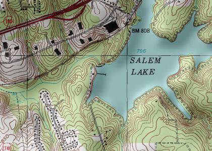
Salem Lake is a 365-acre municipal
water source reservoir for the city of Winston-Salem and
surrounding Forsyth County. The reservoir was created by the
original dam built in 1911 across Salem Creek. The third Salem Lake
dam, built in 1931, is still in operation, holding back one billion
gallons of water, or 30 percent of the city’s drinking water.
The dam created a 365-acre lake. Surrounding the water sits another
1,400 acres of parkland, chiefly wooded.
The wooded area is a riparian
zone, which is an interface between the land and a
stream, river or lake. Riparian zones are significant because of
their role in the hydrologic cycle, soil conservation and influence
they have on aquatic ecosystems. Riparian zones occur in many forms
including grassland, woodland, or wetland. These zones are
important natural biofilters, protecting aquatic environments from
excessive sedimentation, polluted surface runoff and erosion.
Essentially, it is the watershed area. They supply shelter and food
for many aquatic animals and shade that is an important part of
stream temperature regulation.
Water is essential to life.
Without it, the biosphere that exists on the surface of the earth
would not be possible. Earth is covered by one of our most precious
resources, water. However, almost 93% is locked in the oceans,
toxic to humans and many plants and animals. How do we obtain fresh
water resources then? Where does drinkable water come from? To
understand, we need to turn to the Hydrologic Cycle.
One special characteristic of water is its ability to change state
very easily under Earth conditions. It can be found readily on the
planet in all of its three forms, solid, liquid, and gas. These
forms also play a great part in the hydrologic cycle. Now, exactly
what is the hydrologic cycle? The hydrologic cycle takes place in
the hydrosphere. This is the region containing all the water in the
atmosphere and on the surface of the earth. The cycle is the
movement of water through this hydrosphere from the Earth to the
atmosphere and back to Earth again.
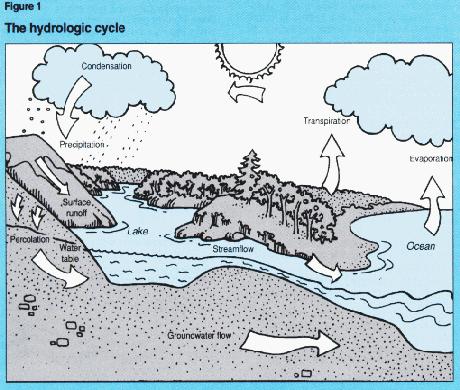
The process begins with condensation. It’s when water vapor
in the atmosphere condenses to form clouds. Eventually, when the
clouds can’t hold the moisture any longer, precipitation
happens. Then, infiltration occurs when precipitation seeps into
the ground. This depends a lot on the permeability of the ground.
Permeability is the measure of how easily something flows through a
substance. The more permeable, the more precipitation seeps into
the ground. If precipitation occurs faster than it can infiltrate
the ground, it becomes runoff. Runoff remains on the surface and
flows into streams, rivers, and eventually large bodies such as
lakes or the ocean. Infiltrated groundwater moves much in the same
manner as it recharges rivers and heads towards large bodies of
water. From all this water, evaporation occurs changing the water
into vapor in atmosphere.
Before human modifications, water naturally went through many
different naturally occurring riparian areas before reaching
waterways like creeks, streams, rivers and natural lakes. Man has
since come along and made hydrologic modifications, working around
this natural flow, and forcing water more directly into man’s
desired waterways. Where the boundaries of a water flow path are
close together, a dam may be built. The dam built on Salem Creek,
creating a large reservoir, Salem Lake, is a hydrologic
modification and is still a part of the hydrologic cycle. Depending
on rain fall, the amount of water passing over the dam will
vary.
Thank you for your interest in this Earth Cache and I
hope you enjoy your day on the lake!


Developed
by a Platinum EarthCache Master
To receive credit for this Earth Cache, you
must paddle to the posted coordinates out into this man-made
hydrologic modification to answer the following questions. The dam
will be on your left. Answers via email only. Logs with answers
posted in them will be deleted immediately.
The ONLY authorized place to launch a boat is from the Salem Lake
Marina. Boaters must check in at the Fishing Station before
launching their boat. Please observe hours of operation and all
park rules!
1. Take and post a picture of yourself in your boat along with your
GPSr with the Salem Lake Marina in the background. A portion of
your boat must be visible in the picture.
2. What topographical features do you see around the dam? Why do
you think the dam was built where it was?
3. Estimate the width of the dam.
4. Evaluate the current hydrologic cycle occurring on the day of
your visit. What are the conditions?
5. What characteristics do you observe about the water in Salem
Lake? Clarity, pollutants, surface conditions,
etc.
The picture MUST be uploaded immediately after
posting your log AND the answers to the questions MUST be sent
within a reasonable amount of time on the same day as you claim
your smiley. All logs not complying will be deleted without notice.
As of 7-30-09, I will no longer send out reminder emails asking for
the information.
Additional Hints
(Decrypt)
[The dam will be on your left as you paddle out to the posted coords.]