The coordinates for the Pyramid Lake Earthcache
takes the cacher to Pyramid Island which can be accessed via a
boardwalk jointly built by Parks Canada and the
Friends of Jasper National Park.

Mount Edith Cavell can be seen to the southeast
when crossing the boardwalk. Mount Edith Cavell is
one potential source of the Gog quartzite erratics which form the
Foothills Erratic Train stretching from Jasper National Park to
Montana in the USA. The Ramparts in the Tonquin Valley and the
Endless Chain Ridge on the Icefields Parkway are other possible
sources. Several well known erratics from this area can be found in
Calgary area - The Big Rock near Okotoks and Crater Rock in the
northwest Calgary community of Panorama Hills.
Nearby Mount Edith Cavell is one of the most
prominent landmarks in the Athabasca Valley. Voyageurs looked for
the massive face of “La Montagne de la Grande Traverse”
to guide them to the Athabasca Pass and the fur trade route to the
west. Today at Mount Edith Cavell, visitors have unparalleled
opportunities to discover three types of glaciers, a variety of
moraine, primary plant colonization in the wake of the retreating
Angel Glacier, and the sheer north face of Mount Edith Cavell.
Mount Edith Cavell and the Foothills Erratics Train
Erratics are large boulders that have been transported and
deposited by glaciers. In southern Alberta, along the eastern side
of the Rocky Mountains, thousands of erratics form a train over 600
kilometers long. When geologists examined the rocks, they
discovered that they were all made of the same kind of rock, and
they traced the source of that rock to an area around Mount Edith
Cavell in Jasper Park. Thousands of years ago, these large stones
fell onto the surface of the Cordilleran ice sheet during a
landslide, and then were slowly carried by the ice sheet outward
onto the Plains. When the ice melted, the long train of boulders
was left behind.
These rocks contain clues that have helped scientists to
understand the movements of the ice sheets that covered Canada
during the Late Wisconsinan glacial stage. The pathway of the
erratics takes a sharp right-angle turn out on the Plains, changing
from an easterly to a southerly direction. Scientists believe that
the western Cordilleran ice sheet which was carrying the erratics
met the eastern Laurentide ice sheet, and got deflected
southward.
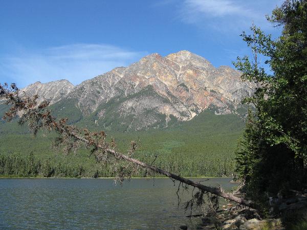
Pyramid Lake and the peaks in the immediate
vicinity were carved long ago by the glaciers in the area.
In order to log a find for this Earthcache please e-mail
the cache owner (don't post) answers to the following
questions:
1. Pyramid Mountain was carved from the hardest rock layer in
Jasper National Park. What was the name of the rock layer? What was
the composition of the rock layer? What well known mineral can also
be found in the rock and what is it's commonly known name?
2. What caused the pink and orange hues which can be seen in
Pyramid Mountain?
3. How deep is Pyramid Lake? Why isn't it as deep as some of the
other lakes in the area?
4. Post a picture of yourself at the Earthcache site with GPS in
hand and the Pyramid Mountain back drop.
Enjoy!