 For 100 years, the National Park Service has preserved America’s special places “for the enjoyment, education, and inspiration of this and future generations.” Celebrate its second century with the Find Your Park GeoTour that launched April 2016 and explore these geocaches placed for you by National Park Service Rangers and their partners.
geocaching.com/play/geotours/findyourpark
Looking north from this spot, what you see is the Cumberland Mountain. The most prominent and visible area is called the White Rocks. The White Rocks are what is known as Greenbrier Limestone and was formed from sediment some 350+ million years ago. Yes, the White Rocks were once under a vast sea. The White Rocks are cliffs that are a few hundred feet tall. (You will later have to guess how high?) On the south face of Cumberland Mountain in Virginia there are over 20 caves. These caves vary in size from 15+ feet to under 7 miles. These caves are referred to as solutional caves, which are caves formed in rock that is soluble. Limestone is very soluble. For now, we will leave the exploration of the 24 caves to others and perhaps future Earthcache listings. The cliffs of the White Rock formation are also Greenbrier limestone that has been exposed and weathered over the last few million years.
Because the White Rocks were so prominent from the Wilderness Road in Virginia, they served as a marker for early travelers in the valley below as they moved west toward Cumberland Gap. When the cliffs came into view atop Cumberland Mountain, shining in the afternoon sunlight, travelers knew they had one more day to the protection of the Gibson Station. At the Station, they would assemble in groups for mutual protection against Indians during the treacherous journey through the Cumberland Gap
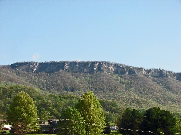
The White Rocks of the Cumberland
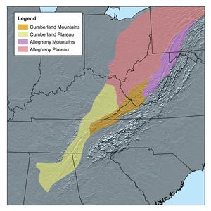
The Cumberland Plateau is a physiographic section of the larger Appalachian Plateau province, which in turn is part of the larger Appalachian physiographic division.
The Cumberland Plateau is contiguous with the Allegheny Plateau on the northern side, the only real difference being local naming. The sedimentary rocks that compose both plateaus are of Mississippian and Pennsylvanian geological age, composed of near shore sediments washed westward from the old Appalachian Mountains. Some rock layers were laid down in shallow coastal waters, some, including bituminous coal seams were laid onshore in swampy environments. These are interlaced with delta formations of cross-bedded sandstones and occasionally conglomerate. There are numerous discontinuities in the beds, where they were raised high enough to be eroded, then lowered to have more sediments added on top.
The Appalachian Mountain range is old. The formation of the mountains is estimated to have begun 680 million years ago. It was formed during the Paleozoic Era. In an event called the Alleghanian Orogeny, the ocean crust was subducted beneath the continent that would later (much later) be named North America. This made the later named Africa drift closer to North America. The continents continued to drift until they collided. The ‘super collision’ caused the land to fold upward thus creating the Apppalachian Mountains. The mountains are made mostly of sedimentary rock. Because sedimentary rock is ‘easily’ eroded, the mountains a were once a great mass that have been eroded over millions of years by nature’s wind, rain and streams of water.
The diagram below depicts the expanse of the Appalachian Mountain range and it’s sub-chains. As stated earlier, the White Rocks are part of the Cumberland Mountain which is part of the Cumberland Plateau.
We talked about the White Rocks (Cliffs) being Greenbrier limestone so a word or two as to just what is limestone may be in order. Limestone is a sedimentary rock, which in turn is one of the three major classifications of rocks. Igneous and metamorphic rocks are the other two. Among sedimentary rocks are:
****TYPES OF SEDIMENTARY ROCK****
1. Sandstone: sand grains cemented together
2. Shale: clay particles smaller than sand
3. Conglomerate: mostly quartz pebbles cemented together
4. Limestone: made of calcium carbonate often deposited by sea life
5. Dolomite: very much like limestone but with more magnesium in it
6. Coal: composed of the remains of plants and animals

The Formation of Sedimentary Rock

Up Close!
Please Note: In order for you to claim a find on this Earthcache you must post a picture of your GPSr pointing to the Cliffs.While it would be nice, you do not have to have to show your face(s) in the photo.You also must email answers to the following questions: 1. What is your current elevation? 2. Estimate the height of the White Rocks. 3. An easy one; what type of rock are the Cliffs? Please remember, email the answers only as posted answers will result in a deletion of the log.
Our thanks goes out to the Cumberland Gap Park staff for their approval to develop this EarthCache. A special thanks goes to Ms. Carol Borneman, Supervisory Ranger and to Mr. Mark Woods, Park Superintendent.
This Earthcache was approved by the Geological Society of America
| We have earned GSA's highest level: |
 |
| FTF HONORS GO TO: Heironimus |