Burgstein bei Dollnstein EarthCache
-
Difficulty:
-

-
Terrain:
-

Size:  (not chosen)
Please note Use of geocaching.com services is subject to the terms and conditions
in our disclaimer.
English description see below.
 Deutsche Version
Burgstein bei Dollnstein
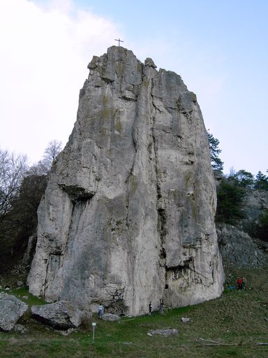 Der turmartig aufragende
Burgstein (auch Burgsteinfelsen genannt) ist Teil eines
Felsmassivs, das in einem subtropischen Flachmeer des Jura
abgelagert und von Ur-Donau und Altmühl herausgewaschen
wurde.
Der turmartig aufragende
Burgstein (auch Burgsteinfelsen genannt) ist Teil eines
Felsmassivs, das in einem subtropischen Flachmeer des Jura
abgelagert und von Ur-Donau und Altmühl herausgewaschen
wurde.
Der Bayerische Staat führt den Burgstein als Nr. 3 der schönsten
Geotope Bayerns.
Die Entstehung des Burgsteins
Zur Zeit des Oberen Jura vor ca. 154 bis 135 Millionen Jahren war
Süddeutschland von einem flachen subtropischen Schelfmeer bedeckt.
In diesem Flachmeer wechselten seichte Plattformen mit sandiger
(grobkörniger) Kalkablagerung und tiefere Wannen mit
schlammig-tönerner (feinkörniger) Kalkablagerung. Das Material für
diese Kalksände und -schlämme lieferten die Schalenreste
abgestorbener Meerestiere – wie Schwämme, Kalkalgen, Brachiopoden,
Seelilien und Seesterne; Versteinerungen unter anderem von
Ammoniten, Fischen und Meeresreptilien haben sich in den Kalken der
Wannen erhalten. Am Gesteinsaufbau der Plattformkalke haben
sogenannte Ooide und Peloide einen wesentlichen Anteil, an den
Hängen der Plattformen wuchsen Schwammriffe.
Der 50 Meter hohe Felsen des Burgsteins besteht im wesentlichen aus
massiven Plattform-Kalken mit eingestreuten Schwammriffen. Während
die feinkörnigen Schichten der Wannen im Laufe der Zeit durch
überlagernde Sedimente stark verdichtet wurden, widerstanden die
die Kalke der Riffe und Plattformen dem Gebirgsdruck und blieben
als Tafeln und mächtige Blöcke erhalten.
Vor etwa 5 Millionen Jahren begann sich die Ur-Donau ihren Lauf
durch die weichen Ablagerungen der Kreidezeit und des Tertiärs zu
bilden. Als der Fluss auf das härtere Juragestein stieß, versuchte
er dem Verlauf der etwas weicheren Wannenkalke zu folgen. Die
Erosion bildete dabei bevorzugt die härteren Plattform-Kalke heraus
und an den Prallhängen des Flusses entstanden die eindrucksvollen
Felsenwände und -türme.
Während der Riss-Eiszeit vor ca. 150.000 Jahren verlegte die
Ur-Donau ihren Lauf nach Süden, seitdem fließt die Altmühl durch
das Tal von Dollnstein am Burgstein vorbei.
So findet ihr den Burgsteinfelsen
Von der Ortsmitte Dollnstein biegt ihr ab in Richtung
Eberswang/Schernfeld, am Ortsende (N 48° 52.640 E 011° 04.470)
folgt ihr den Hinweisschildern nach Osten Richtung Sportplatz. Das
Geotop befindet sich ca. 1,5 km nach dem Sportplatz direkt am
Altmühl-Radweg Richtung Eichstätt.
Parken könnt ihr direkt am Fuße des Burgsteinfelsens (N 48° 52.075
E 011° 05.590).
Bei schönem Wetter empfehle ich allerdings die Parkplätze hinter
dem Sportplatz (N 48° 52.540 E 011° 04.905) und die kurze Wanderung
oberhalb der Straße entlang des Altmühltal-Panoramaweges (bei N 48°
52.595 E 011° 04.830 dem Pfad hangaufwärts folgen).
Bei den Koordinaten N 48° 52.125 E 011° 05.685 führt euch ein
Trampelpfad wieder nach unten bis an den Fuß des Burgsteins. Folgt
ihr allerdings dem nach Süden führenden Trampelpfad weiter nach
oben, gelangt ihr zu einer Felsplattform bei N 48° 52.078 E 011°
05.647. Dort seid ihr auf fast gleicher Höhe wie der hinter einer
Spalte aufragende Burgsteinfelsen und könnt einen wunderbaren Blick
über das Altmühltal genießen.
Auf der Infotafel bei N 48° 52.042 E 011° 05.604 findet ihr manche
Antworten, die ihr braucht, um loggen zu können.
Um diesen Earthcache loggen zu dürfen, müsst ihr folgende
Aufgaben erfüllen bzw. Fragen beantworten:
 1. Macht ein Foto von euch und
eurem GPSr mit dem Burgsteinfelsen im Hintergrund.
1. Macht ein Foto von euch und
eurem GPSr mit dem Burgsteinfelsen im Hintergrund.
2. In welche Serien und Stufen lässt sich das Zeitalter des Jura
unterteilen?
3. Was sind Ooide und Peloide?
4. Auf vermutlich wieviel Grad nördlicher Breite lag Süddeutschland
in der Zeit des Malm?
5. Messt die Länge und Höhe des rechten der beiden Felsen, die am
Fuße des Burgsteinfelsen in der Nähe der Infotafel liegen (siehe
Foto).
6. Am Ostfuß des Felsens könnt ihr die Querschnitte verkieselter
Schwämme, die sich hier abgelagert haben, erkennen. Schätzt die
Höhe der von ihnen gebildeten Gesteinsschicht.
7. Sendet die Antworten auf die Fragen 2 bis 6 an Beleman.
8. Fügt eurem Log das Foto von Aufgabe 1 hinzu.
 English Version
Burgstein near Dollnstein
Burgstein consists of the
German words Burg (castle) and Stein (stone).
Sometimes the Burgstein is also called Burgsteinfelsen
(the German word Felsen means rock).
The towering Burgstein is part of a rock massif which has been
sedimented by a subtropical shallow sea of the Jurassic and has
been eaten away by the so called Urdonau (original Danube) and the
Altmühl.
The State of Bavaria conducts the Burgstein as no. 3 of Bavarias
most beautiful geotopes.
The origins of the Burgstein
At the time of the Upper Jurassic approximately 154 to 135 million
years ago Southern Germany has been covered by a subtropical
shallow shelf sea. In this shallow sea shoal platforms with sandy
(coarse-grained) calcification alternated with bowls of
muddy-fictile (fine-grained) calcification.
The material for this limy sand and alluvium has been supplied by
the shells of dead marine fauna – such as sponges, calcareous
algae, brachiopods, sealilies and starfish. Fossils, e.g. from
ammonites, fish and marine reptiles, preserved themselves in the
limescale of the bowls. So called ooids and peloids have a
significant part in the buildup of the lime platforms. Reefs of
sponge grew at the hillside of the platforms.
The 50 meter high cliff of the Burgstein mainly consists of a
massive platform of limestone interspersed with sponge reefs. While
the fine-grained layers of the bowls have been heavily compressed
by overlying sediments over time, the limestone reefs and platforms
resisted the rock pressure and remained as mighty panels and
blocks.
About 5 million years ago the original Danube started its course
through the soft sediments of the Cretaceous and the Tertiary. When
the river ran across more solid rocks of the Jurassic, it tried to
follow the course of the somewhat softer calcification of the
bowls. Erosion formed out the more solid platforms and at the
undercut slope of the river, the impressive rock faces and tors
developed.
During the Riss glaciation, about 150,000 years ago the original
Danube relocated its course to the south. Since then the Altmühl is
flowing through the valley of Dollnstein, passing the
Burgstein.
How to find the Burgstein
From the towncenter of Dollnstein you turn off to the direction
Eberswang/Schernfeld. At the end of the town (N 48° 52.640 E 011°
04.470) you follow the signs eastward towards the sports field
(Sportplatz). The geotope is to be found about 1.5 kilometers
behind the sports field, directly at the Altmühlvalley cycle track
towards Eichstätt.
Parking is available directly at the Burgsteinfelsen (N 48° 52.075
E 011° 05.590).
But on a nice day I would suggest parking behind the sports field
(N 48° 52.540 E 011° 04.905) and having a nice walk above the road
along the Altmühltal-Panoramaweg (at N 48° 52.595 E 011° 04.830
follow the path uphill).
At N 48° 52.125 E 011° 05.685 a trail leads you downhill to the
foot of the Burgstein. If you follow the trail to the south uphill
you’ll reach a plateau at N 48° 52.078 E 011° 05.647. There you are
nearly at the same level with the Burgstein and can enjoy the
beautiful view to the Altmühlvalley.
On the information board at N 48° 52.042 E 011° 05.604 you’ll find
some of the answers you may need to log the cache.
How to get logging permission
Execute the tasks and answer the
questions below:
1. Take a photo of you and your GPSr with the Burgstein in
background.
2. In which series and stages the Jurassic can be subdivided?
3. What are ooids and peloids?
4. At presumably how many degrees northern latitude Southern
Germany has been in the age of Malm?
5. There are two rocks at the foot of the Burgstein near the
information board. Meter the length and the hight of the rock on
the right hand (see photo).
6. By the east foot of the rock you can find the profiles of
silicified sponges, which sedimented here. Estimate the height of
the rock formation formed by these sponges.
7. Mail the answers for task 2 to 6 at Beleman.
8. Ad the photo of task 1 to your log.
Additional Hints
(No hints available.)