A dome is a feature that has symmetrical anticlines, and the outline on a map is usually circular or oval. The strata of rocks are up warped toward the center. A salt dome is a geologic formation formed when a thick bed of evaporite minerals (normally salt, or halite) from far below the Earth’s surface intrudes vertically into surround rock strata.
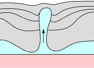
This process forms a diapir, an intrusion in which more flexible material is forced into overlying rocks. Diapirs tend to intrude vertically into weaker layers, usually disconnecting the strata and uplifting these layers along with them. They are bulbous in shape (think lava lamp blobs rising to the top). In this case, salts and other evaporated minerals are generally lighter than the sedimentary rock which surrounds them, and as a result, salt has a tendency to well up.
The salt that forms these domes originally came from the ocean. During the Triassic time, some 200 million years ago, this area was covered by a vast, shallow sea. Over time, the waters continually evaporated, leaving salty deposits of evaporated minerals behind. Over time this process is believed to have occurred numerous times and eventually formed the Louann Salt, a layer of salt ranging from approximately Eastern Texas to Western Alabama, and from the Gulf of Mexico to the present latitudes of Shreveport and Dallas. Located miles beneath the surface, the Louann Salt (often called the Mother Bed) is estimated to range in thickness from approximately 5,000 feet to over three times that thickness. Over time, this large layer was later buried by an even greater layer of sediments.
Salt occurring naturally as a mineral is called Halite, or rock salt. When you think of salt, you normally think of table salt crystals or rock salt, which is hard. When heat and pressure enter the equation, salt becomes soft, plastic, and becomes a fluid that can actually flow. This fluid may be more like toothpaste and less like running water, but it flows nonetheless. Over time, as more and more sediments buried the salt deeper and deeper, the salt became hotter and hotter and under more and more pressure. This made the salt more pliable. The weight of the sediment bore down on the salt, which then flowed upwards, creating pillars, domes, needles, and ridges -- some of which rise tens of thousands of feet above the main layer of salt. Normally, these features are still well below the surface and are unseen to our eyes.
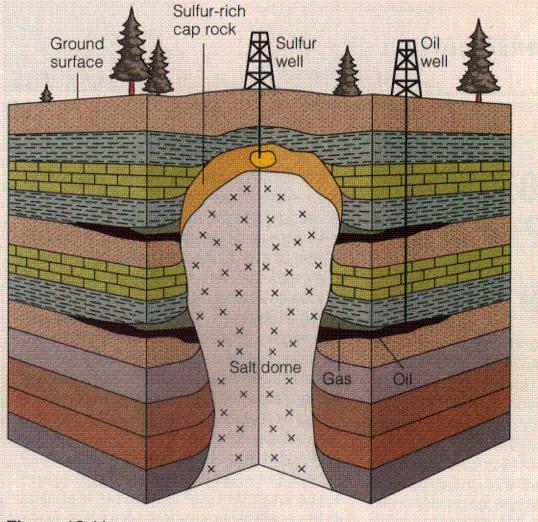
The salt will rise to the top of the sediments because the salt is less dense than its surrounding sediments, and because under the pressure and the heat, it can flow. When salt flows and rises upward the salt creates a distinctive bulge. It appears to be boring its way straight through the surrounding rock when viewed in cross-section. When the top of a salt dome is within a few thousand feet of the surface, groundwater circulates through the salt dome and surrounding sediments. This circulating water dissolves halite and precipitates residues, such as gypsum, anhydrite, native sulfur, and calcite, in open solution cavities in and around the crest of the salt dome. Over time, these can then form a cap rock over the top of the salt dome.
Occasionally, salt domes breach the surface, creating a visible bulge in the surface of the Earth. This breach is often capped with a layer of rock. In some cases where the salt pierces through the surface without cap rock the salt dome can form a salt glacier, where gravity causes the salt above the surface to flow into surrounding valleys.
Salt domes can be found all over the world. Some are in desert environments (which may seem strange now, but this illustrates that these areas, too, were once under seawater), while others are in marshes and swamps near the ocean.
Salt domes have been utilized for centuries as readily available supplies of salt, since they typically contain a high concentration of halite, otherwise known as table salt. Salt domes often contain pockets of oil and natural gas which become trapped as the salt rises. These deposits have nowhere to go until they are drilled, and they can be quite significant. The caprock above the salt domes is sometimes the site of deposits of native sulfur.
Salt is inert and thus is an extremely stable storage medium. After excavating the domes themselves for uses in everything from table salt to the granular material used to prevent roadways from icing over, the caverns formed are used for numerous purposes, including storing deposits of fuel, natural gas, hydrogen gas, nuclear and other hazardous waste, and even records storage. The cap rock itself is often mined for various minerals, often sulfur, and even the rock itself.
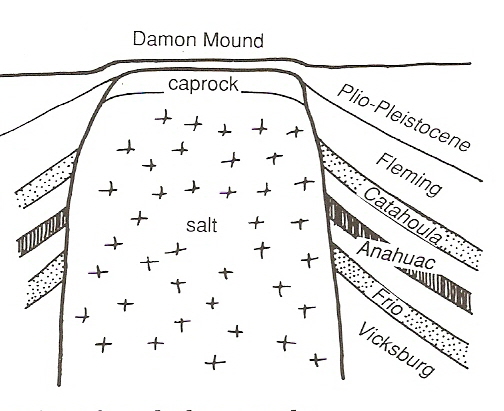
Damon Mound
Salt domes do not commonly reach the surface, and they are not prominent features in Texas. They are an important subsurface feature in the state, though, mostly because of the related oil, gas, and other minerals that is found in and around them. There are over 500 salt domes mapped in the subsurface in East Texas.
As you approach Damon you are traveling through flat coastal plain. Much of this is farmland with rich brown soil. As you get closer to the city, a hill appears. Looking out of place, this hill rises about 80 feet above the coastal plane. This is one of the best surface expressions of a salt dome to be seen on the Gulf Coast, and one of only a few that have a surface expression at all in Texas. Most salt domes exist below the surface of the Earth and you would never know they were there just by looking at the landscape.
On the northwest corner of Damon Mound is an abandoned quarry. The stone that was mined here was made from Oligocene-age coral reefs (Anahuac formation) buried deep beneath the surface. The rock was used for building materials and crushed gravel. Some time ago, sulfur was also an important mineral mined from the cap rock. Oil wells used to surround the mound in great numbers and outlined the salt dome. These wells pumped millions of barrels of oil out of the ground over the years.
The Damon Mound salt dome has pushed its way up from the Jurassic Louann salt layer thousands of feet beneath the surface to create the mound, which is mostly made of ancient sea reef. This unique exposure is the result of the rare coincidence of 3 factors: the formation of a coral reef over an active piercement salt dome, its preservation in caprock through over a mile of uplift, and its excavation and exposure by quarrying operations. Fossils of corals, clams, and one-celled foraminifera are the builders of this reef that makes up the predominance of this cap rock.

To claim this EarthCache, please do the following:
Visit the following 4 waypoints (all along a public gravel road, and relatively quick drive. You don‘t even have to get out of your car, except maybe for the photo!).
1) N 29 16.837 W 095 45.176
2) N 29 17.030 W 095 45.409
3) N 29 17.489 W 095 45.857
4) N 29 17.562 W 095 45.945.
Start your journey at WP-1. You can use this waypoint for your task in Question A, below. Travel the short distance to WP-2. There is a piece of oil history standing tall near here, if you look directly Southwest. You’ll want to take your photo for Item 2, below, at WP-2. Continuing on to WP-3, by looking due East you get a good view of one of the hills comprising Damon Mound. Due to tree cover, it’s difficult to have a clear view of it. But driving along Stockwell Road you have (or will) really be able to tell the incline / altitude gain the salt dome has created. Travel onward just a little farther to WP-4, and you will see the hills around the old rock quarry off to the North.
All along the way you will see lots of old oil equipment from ages ago when production was booming on and around the salt dome. Just imagine how much more is out there in other places nearby you cannot see!
1) Before logging a Found log, E-mail me the answers to the following questions:
A) By traveling on Stockwell Rd., estimate the rough diameter of Damon Mound. You can use WP-1, select go-to, and see how far you are from it (as the crow flies) on the other side of the mound. Please let me know where your measuring point on the other side was, in terms of nearness to roadway intersections or landmarks, etc.
B) Looking at the cross section illustration of the salt dome making Damon Mound (first diagram, above), you see that Plio-Pleistocene and Fleming age flank rocks are tilted due to being lifted from the salt diapir. Do you think that the tilting of this layer indicates that the salt intruded and pierced the surface more recently or longer ago -- geologically speaking? Why?
C) What was the highest altitude you traveled to during your visit? Where was it and how did you get there? (Remember, you proably came over Stockwell Rd.)
2) Please post a picture of yourself or your GPSr at one of the waypoints. There used to be a really cool sign at WP2, but it's gone now. (See the Gallery). So under the new rules I can't make you, but come on -- post some photos!
After e-mailing me the answers, please go ahead and log your find and upload your photo. DO NOT include these answers in your log or your log will be subject to immediate deletion.
Remember, there are lots of neat and interesting photo opportunities all over the area. Post photos - everyone loves them!