Sibley County’s High Island Creek Park is basically in its
natural state. Only the picnic area has been developed. The names
derived from the creek that meanders through the park for some
3,000 feet. The High Island Creek eventually enters the Minnesota
River several miles downstream – north of the community of
Henderson. Because of the creek valley, the park’s topography
varies from gently rolling to steep slopes and in some areas sheer
cliffs. Most of the park presents heavily wooded virgin acreage
with the trees being typical of the varieties found in Minnesota’s
hardwood forests.
Access to the park is from the north. It may be reached by
traveling east on CSAH 12 from it’s junction with State Highway 5
(1/2 mile north of Arlington) for approximately 6 miles. (watch for
park signs) or by traveling north from Henderson on CSAH 6 to CSAH
12 (approximately 2.5 miles north of Henderson) and then west on
CSAH 12 for approximately 3 miles. (Watch for park signs)
Details
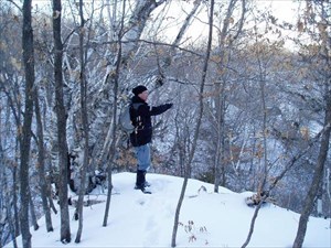
Caching the day with King Boreas and IncredibleMagpie and we
ended up over in this County Park. Sounds like IncredibleMagpie had
been in here before and on a tour of the area we went. Lets go up
there "Yeah Right". So, UP, UP and then UP some more we went. Glad
we did, there were some great views, on this excellent
adventure.
Cache is on a bluff that looks over a tributary of High Island
Creek.
Walking over and up to this cache will be interesting, finding
it could be a bit of a trick too, even though it is a regular size
container. There is a trail that leads up along the ridge line, but
it is not marked very well. Enjoy the views from up on the bluff as
you are walking around, but be careful. "Yeah Right", there are
spots that are a long way down.
Now all you have to do is head out and hunt this one
up.
CACHE ON!!!