First State Challenge 2009- Pike Creek Valley - hidden by MikeOtt


The 2009 First State Challenge sponsored by Delaware Geocachers ended in mid May. There were 17 new caches spread across the state of Delaware by volunteer cachers to give you an appreciation for the great areas of the First State. Over 90 cachers representing 5 states completed the challenge. Although the challenge is finished, the individual caches are still available to be found.
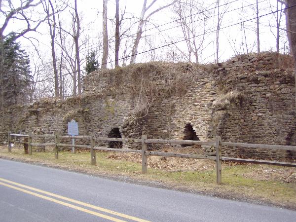
Pike Creek Valley- Lime Kilns
History/Cache
Between Newark and Wilmington there are no formal towns, having only County government. You will be visiting an area that came to be called Pike Creek Valley and the home of thousands of people.
The first stop of your visit is to the remains of the Eastburn-Jeanes lime kilns that started operation in 1816. Limestone was loaded into the kilns along with layers of wood. After days of the wood burning, the limestone was converted to quicklime for use as fertilizer and mortar. The partially preserved ruins of the multi-kiln industrial complex can be seen directly on Upper Pike Creek Road where there is barely parking for one car. This is private property but visitors are welcome so long as you stay outside the split rail fence. Please be respectful of the ruins. The property owner has given approval for this cache.
You need to read the historical marker for information that will give you the coordinates to the final cache:
N39° 42.A08 W075° 41.B18
A = Number of words on first two lines of marker
B = First digit on bottom right of marker (N.C.- ?3)
This will take you on a few miles drive down Upper Pike Creek Road. Shortly you will pass artificial wetlands on your left next to the golf course. Continue down the narrow winding road as you follow the stream, crossing New Linden Hill Road. You can park at the bridge, which is very close to the trailhead for the final stage. The trail will take you exactly to the cache, but I am sure many cachers will want to take a shorter more adventuresome route as they get close to the cache which is a 50 cal ammo can.
The development of Pike Creek Valley took off in the 1960’s with housing developments and shopping Centers on both sides of the valley off of both Limestone Road and Polly Drummond Hill Road. What started as rural area with very early industry has now become a massive suburban area.

This 50 cal ammo can has been placed in White Clay Creek State Park with approval of park management.