Godulsky piskovec / The Godul sandstone EarthCache
Godulsky piskovec / The Godul sandstone
-
Difficulty:
-

-
Terrain:
-
Size:  (not chosen)
Please note Use of geocaching.com services is subject to the terms and conditions
in our disclaimer.
Godulský pískovec /
The Godul sandstone
[CZ]
Godulský pískovec je jemnozrnný velmi tvrdý odolný pískovec
nazelenalé barvy, který - snad jako jediný v Evrope - se dá i
leštit.
Své jméno získal po hore „Godula“ – 738 m.n.m.
(Moravskoslezské Beskydy), kde je težen.

Godulský pískovec je geologickou vrstvou slezského príkrovu (cást
karpatské geologické soustavy) pocházející ze strední krídy. Místy
až 2000 m mocné souvrství odolných pískovcu je základem
centrální cásti Moravskoslezských Beskyd, Slezských Beskyd a
skupiny Ondrejníku.
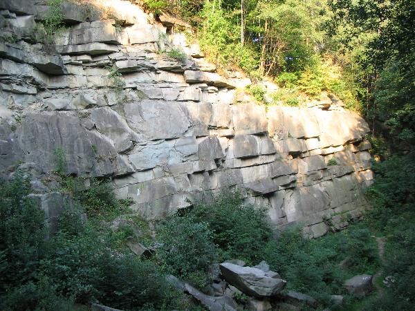
V soucasné dobe slouží bývalý kamenolom jako cvicná skála pro
horolezce. Stena je vysoká 20 m a široká cca 100 m.
Rozdeluje se na tri cásti. Levá cást je nejcasteji používaná,
jelikož není previslá a nabízí spoustu polic. Strední cást je
znacne rozlámaná a nevhodná pro lezení. Pravá cást je
vetšinou previslá a tím vhodná i pro nácvik prusíkování a
cinnost po pádu horolezce. Je zde 33 lezeckých cest, které jsou
zajišteny kruhy a borháky.
V areálu steny mohou horolezci táborit pod podmínkou
dodržování návštevního rádu CHKO Beskydy.
K uznání logu je treba:
1. Priložit svoje foto (nebo foto své GPS) v lomu - od
1.1.2011 nepovinný požadavek
2. Zaslat (na email uvedený v mém profilu) správné odpovedi na tyto
otázky:
a) Který minerál je základem pískovcu?
b) Jaký je název obce, ve které se nachází nejbližší
funkcní kamenolom s Godulským pískovcem?
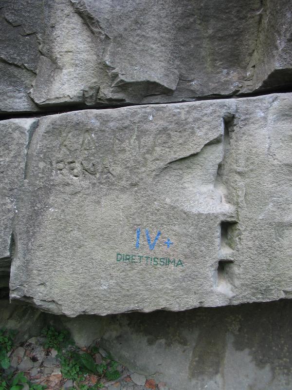
c) Jaká je (zaokrouhleno na dm) tlouštka vrstvy pískovce,
která probíhá celou stenou lomu? Merte v míste nápisu
DIRETTISSIMA!
[EN]
The Godul sandstone is fine-grained, very hard and resistant
sandstone of greenish colour which is, perhaps as the only one in
Europe, suitable for burnishing.
This sandstone gained its name after the mountain called
“Godula” – 738 m.a.s.l. (The Moravian-Silesian
Beskydy) where it is quarried.
The Godule sandstone is a geological layer of the Silesian Nappe
(part of the carpathian geological system) coming from the middle
Cretaceous. Somewhere even 2.000 m high mighty grouping of
resistant sandstones is the base of the central part of the
Moravian-Silesian Beskydy, the Silesian Beskydy and group of
Ondrejník mountains.
Nowadays the former quarry serves as a practice rock for climbers.
The rock wall is 20 m high and about 100 m wide. It is divided into
three parts. The left part is most used since it is not overhanging
and offers many shelves. The central part is rather crumbled and
unsuitable for climbing. The right part is mostly overhanging and
therefore is suitable for prusiking and for the activity after the
fall of climber. There are 33 climbing tracks which are secured
with rings and shanks of the anchor.
In the area of the rock wall it is allowed to climbers to camp out
only on condition of observance of the visiting rules of the PLA
Beskydy.
For recognition of the log it is necessary:
1. To add a photo of yourself (or photo of your GPS) taken in the
quarry - not compulsory since 1 January 2011
2. To send (to the email address given in my profile) the right
answers to these questions:
a) Which mineral is the basis of the sandstone?
b) What is the name of the municipality where the nearest operating
Godul sandstone quarry is situated?
c) What is the thickness (rounded to decimeters) of the sandstone
layer that leads through the whole wall of the quarry?
Measure in position of the title “DIRETTISSIMA”!
Edit:
[CZ] Od 28.09.2009 lze v lomu odlovit i horolezeckou keš
Muffinka´s Action by rubick & muffinka (GC1Z59A).
[EN] Since 28 September 2009 there is a new climbing cache in the
quarry called
Muffinka´s Action by rubick & muffinka (GC1Z59A).
Additional Hints
(No hints available.)