An earthcache is a virtual
cache designed to show and simply explain a geological feature,
more details can be found at ww.eathcache.org. The coordinates are
for a car park (payment required) although you can park at the
bottom of the hill for free subject to space being available near
N53.20.568 W001.47.251. In the summer parking may be more difficult
due to the volume of tourists, so please plan the time of your
visit carefully.
Winnats Pass is a SSSI (Site of
Significant Scientific Interest) and therefore protected because of
its spectacular geology. The hole of Winnats Pass is under
management of The National Trusts High Peak & Longshaw Estate
Office, to whom we thank for consenting to this
earthcache.
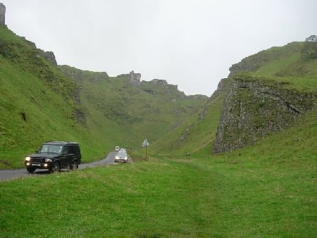
Background: Winnats Pass is a narrow limestone
gorge which is the only direct route from the west of Castleton in
the Hope Valley towards the top of the limestone plateau above. It
climbs 1300 feet up through a dale. The name Winnats is short for
'Windygates' and on a windy day you will see why it came by that
name, for the wind seems to swirl around everywhere. Past
generations believed Winnats Pass was a collapsed cave, however
modern geologists have discovered a more complex and more ancient
origin.
The valley was created by the action of
water eating away at the limestone rock - water gradually dissolves
the limestone and the streams tend to find their way underground by
gradually enlarging the natural cracks and fissures in the rock.
The formation of the Pass can be dated back over 300 million years
ago to the time when it was a coral
reef.
In time this reef was
covered in mud and sand, which in time turned into shale and
sandstone rock. The remains of the coral reef turned into limestone
when millions of sea creatures were preserved as fossils.
Eventually the reef was buried below some 3 km of rock, however as
time moved on the earth movements lifted the rock and the wind and
water slowly wore away the layers of sandstone and exposed the
buried reef. The Ice Age put the finishing touches to the shape of
the pass with a glacier. As it moved westerly , slowly thawing,
torrents of water flowed, but as the ground was still frozen, the
water could not penetrate and subsequently the shale was washed
away.
There are numerous
underground stream systems in this area and these created a large
cave system beneath the edge of the cliff overlooking Castleton.
The valley contains a number of known pot-holes and Speedwell
Cavern (one of the area's many show caves) has its entrance at the
foot of Winnats Pass.
There are numerous footpaths around Winnats Pass and a short walk
up the pass and down by another route is
recommended.
If you are standing at the
coordinates given, more information is available on the notice
board. The fossils mentioned can be seen on the large rock behind
you. please do not take any fossils away without the express
permission of the National Trust. Thank you.
To claim
this earth cache email us via the profile with the
following information
1: The reefs
at Winnats pass were created how many millions of years
ago?
2: Name the fossils that
can be found in the valley today?
Q's: 1&2 can be found
at the coords.
3: In the 18th
Century, the Peak Forest was an area where any couple could get
married day or night. A young couple, Allen (sometimes
refered to as Henry) and Clara, were on their way there in
1758 via Winnats Pass; What happened to them (Research required
i.e.: Internet ).
4: Also log a photo of
yourself, with your GPS at the site. The photo must show the pass
in the background. Night photos NOT accepted. (Please do not log photo until you receive confirmation
your answers to question 1, 2 & 3 are correct. NOTE: Slightly
Silly photo's keep us amused!!!) non approved photo's & claims
of a find will be deleted!
CONGRATULATIONS; FTF AWARD GOES TO
CATS-EYES

The Imp is a Platinum Earthcache
Master.