Note: This cache will NOT be doable during periods of snow
cover or extremely high water levels.
For most of the past 2 million years, much of Ohio
has been covered by massive ice sheets, called
continental glaciers, that
extended down from Canada. These ice sheets ranged in thickness
from several hundred to several thousand feet and dramatically
changed the Ohio landscape. The glaciers advanced south during
intervals of global cooling and retreated north during intervals of
global warming. During other intervals, global temperatures were
just right to hold the glaciers in place for extended periods of
time. Records of these intervals can be found in the rocks and
soils of northern Ohio.
When a glacier advances, it scrapes the surface
beneath it like sandpaper passing over a piece of wood. Some of the
rocks and soil scraped up become embedded in the ice itself and can
be carried extremely long distances. When a glacier retreats (i.e.
melts), it leaves the embedded rocks and soil behind as debris
called till. Many of the rocks
left behind in Ohio by these glaciers are Canadian in origin.
Examples are granite, gabbro, quartz, schist and gneiss—many more
than 500 million years old. These rocks tend to be older and more
varied in size, shape, and color than the gray, angular sandstones
and shales that are native to northeastern Ohio.
An interesting phenomenon occurs when a glacier's
advance is halted for an extended period of time. During the winter
months, the southern edge of the glacier advances short distances,
carrying rocks and soil with it. During the summer months, the
glacier melts back to where it started from, leaving the glacial
till behind. Where this cycle repeats itself over and over again, a
build-up of till occurs at the glacier's southern edge, much like a
pile of stones would build up at the end of a conveyer belt. This
huge pile of rocks and soil is called an
end moraine.
A melting glacier can also have the effect of
dramatically changing the drainage of a region. The large
quantities of water rushing out of the melting glacier can carve
out new streams and change the direction of existing streams. Two
such streams in Cuyahoga Valley National Park are
Furnace Run and its tributary,
Riding Run.
This EarthCache takes you on a hike alongside
Furnace Run and Riding Run to the top of an end moraine. Along the
way you'll see examples of the rocks left behind by the melting
glaciers. The hill you'll be climbing is just a small part of the
end moraine, known as the Summit County
morainic complex, which was formed about 35,000 years
ago and sprawls across the width of northern Summit County.
Please stay on the designated trails at all times
and do not remove any specimens from the park. (Feel free, however,
to pick up any trash you might encounter!) The trail is clearly
marked, but you can also download a
park map
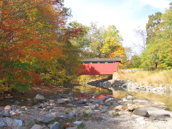
that includes the trail, if you wish. Your journey begins at the
Everett Road Covered Bridge parking lot on Everett Road. See the
coordinates above.
> Follow the path to the covered bridge at
Waypoint 1 (N41° 12.245 W81° 34.998) and take an altitude
measurement. You are standing at the edge of the end moraine where
Furnace Run, below you, and the Cuyahoga River have cut a valley
through it. Notice the direction of water flow in Furnace Run. (You
will need to answer a question about this for the logging
requirements.) Also notice the wide variety of sizes, colors, and
shapes of the rocks in Furnace Run and that some of them are
rounded. This is characteristic of glacial till. Most of these
rocks are Canadian in origin; there is very little native shale or
sandstone here. Note that the soil component of the till has been
washed away.
> Cross the bridge and follow the footpath at
your right as it threads its way between Furnace Run and the road.
Along the way you'll have several more opportunities to observe the
rocks and water flow in Furnace Run. Continue on this path as it
turns right and follow it until it crosses the road to the Riding
Run Trail loop at Waypoint 2 (N41° 12.490 W81° 35.223).
> At Waypoint 2, follow the Riding Run Trail
loop to the left (west). Although you've been climbing the end
moraine ever since you crossed the bridge, you'll really
start climbing now. From time to time along the trail you'll see
the rocks that compose the hill. Although you'll occasionally
encounter some local sandstone, most of what you see will be
Canadian in origin.
> At Waypoint 3 (N41° 12.476 W81° 35.509)
take a moment to enjoy a magnificent oak tree. This is one of many
beautiful trees along this trail.
> Waypoint 4 (N41° 12.470 W81° 35.688) is
at a footbridge. Standing on the bridge you can get a good look at
some of the rocks that make up the hill. You will have to answer a
question about these stones for the logging requirements.
> Cross the footbridge and continue along the
trail heading southwest. Eventually you'll begin climbing to the
top of the hill and the footpath will end at a narrow dirt and
gravel road. Follow the road to the right heading northeast across
the summit of the end moraine.
> As you walk the dirt road, keep an eye on your
GPS and record the altitude AND coordinates of the highest
elevation you observe. You will need these for the logging
requirements. From time to time you'll see a deep valley to your
left. This is where Riding Run has carved its way through the end
moraine.
> Continue to follow the Riding Run Trail as it
loops around clockwise and descends back to Waypoint 2. Follow the
footpath from here back to the covered bridge parking lot.
To claim credit for this cache, you must
answer the following questions:
- What is the altitude at the base of the end moraine (Waypoint
1)?
- In what general direction does the water in Furnace Run flow?
How does this compare to the direction of water flow in the nearby
Cuyahoga and Rocky rivers?
- What do you think caused Furnace Run to flow in this
direction?
- Describe the rocks at Waypoint 4 and compare them in size,
shape, and color to the rocks in Furnace Run.
- What is the altitude, longitude, and latitude of the highest
point you observed on the Riding Run Trail?
- How high is this section of the end moraine, and how does this
compare to the height (thickness) of the glacier that formed
it?
Do not include your answers in your log entry! Instead,
geo-mail them to me within 3 days of your visit. (EarthCaching
rules require me to delete your log if I don't receive your answers
in a reasonable timeframe.)
Thanks to Cuyahoga Valley National Park and
MetroParks, Serving Summit County for permitting this
Earthcache.
If you are interested in creating a new
EarthCache in Cuyahoga Valley National Park, please contact Arrye
Rosser at (440) 546-5992 or arrye_rosser@nps.gov about
becoming an EarthCache volunteer. Note that the national park does
not permit geocaches at this time.
REFERENCES: